

Key Insights
The Asia-Pacific Remote Sensing Satellites Market is poised for significant expansion, projected to reach USD 15.68 billion in 2025. This robust growth is driven by a remarkable Compound Annual Growth Rate (CAGR) of 16.9% over the forecast period. Key accelerators for this surge include the escalating demand for high-resolution Earth observation data from commercial entities for applications such as agriculture, environmental monitoring, and urban planning. Furthermore, increasing investments in national security and defense initiatives by governments across the region are fueling the deployment of advanced military and surveillance satellites. The burgeoning space sector in countries like China, India, and Japan, coupled with technological advancements in satellite miniaturization and improved data processing capabilities, are also major contributors to market dynamism.
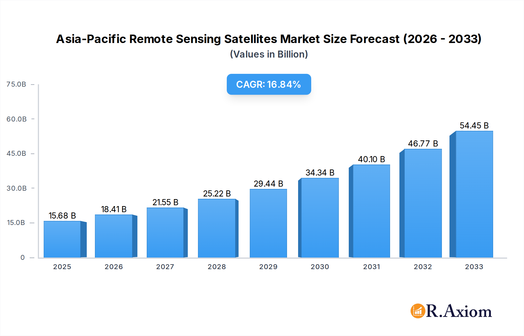
Asia-Pacific Remote Sensing Satellites Market Market Size (In Billion)
The market landscape is segmented by satellite mass, orbit class, satellite subsystem, and end-user, reflecting diverse application needs. The 10-100kg and 100-500kg satellite mass segments are expected to witness substantial adoption due to the rise of small satellite constellations. Low Earth Orbit (LEO) satellites are dominating due to their high revisit rates and suitability for various Earth observation tasks. Key subsystems like propulsion hardware and propellant, along with satellite bus and subsystems, are critical components driving innovation. While the market benefits from strong government and commercial backing, challenges such as the high initial investment costs for satellite development and launch, as well as increasing space debris concerns, present strategic considerations for market participants. The Asia Pacific region, encompassing rapidly developing economies, is a focal point for both satellite deployment and the utilization of remote sensing data, underscoring its pivotal role in the global market.

Asia-Pacific Remote Sensing Satellites Market Company Market Share
This comprehensive report delivers an in-depth analysis of the Asia-Pacific Remote Sensing Satellites Market, projecting a robust growth trajectory fueled by escalating demand for geospatial intelligence across diverse sectors. The study covers the historical period from 2019 to 2024 and provides detailed forecasts for the period 2025–2033, with the base year and estimated year set at 2025. The market is segmented by Satellite Mass (Below 10 Kg, 10-100kg, 100-500kg, 500-1000kg, above 1000kg), Orbit Class (LEO, MEO, GEO), Satellite Subsystem (Propulsion Hardware and Propellant, Satellite Bus & Subsystems, Solar Array & Power Hardware, Structures, Harness & Mechanisms), and End User (Commercial, Military & Government, Other). This report offers actionable insights for stakeholders to capitalize on the evolving opportunities within this dynamic and rapidly expanding market, estimated to reach tens of billions of dollars by 2033.
Asia-Pacific Remote Sensing Satellites Market Market Concentration & Innovation
The Asia-Pacific Remote Sensing Satellites Market exhibits a moderate to high level of market concentration, characterized by the presence of established aerospace giants and an increasing number of agile new entrants. Innovation is a key differentiator, driven by advancements in satellite technology, miniaturization of components, and sophisticated data processing algorithms. Regulatory frameworks, while evolving, are crucial for enabling market access and ensuring data security and privacy. Product substitutes, such as aerial imagery and ground-based sensors, are present but often lack the global coverage and frequent revisits offered by satellites. End-user demand for high-resolution imagery, real-time data, and specialized applications in areas like climate monitoring, urban planning, and disaster management continues to shape product development. Mergers and Acquisitions (M&A) are likely to play a significant role in market consolidation, with potential deal values reaching hundreds of millions to billions of dollars as companies seek to expand their capabilities, geographic reach, and customer base.
- Market Concentration: Dominated by a few key players, with increasing fragmentation in the small satellite segment.
- Innovation Drivers: Miniaturization, AI-powered data analytics, cloud-based platforms, on-orbit servicing.
- Regulatory Frameworks: Evolving policies for satellite data usage, spectrum allocation, and space debris mitigation.
- Product Substitutes: High-altitude drones, advanced aerial photography, ground-based sensor networks.
- End-User Trends: Demand for Big Data analytics, IoT integration, precision agriculture, smart cities.
- M&A Activities: Strategic acquisitions to enhance data processing capabilities, expand satellite constellations, and enter new market verticals. Anticipated M&A deal values are projected to be in the hundreds of millions to billions of dollars range.
Asia-Pacific Remote Sensing Satellites Market Industry Trends & Insights
The Asia-Pacific Remote Sensing Satellites Market is poised for significant expansion, with a projected Compound Annual Growth Rate (CAGR) of approximately 8-10% over the forecast period. This growth is underpinned by several key trends and insights. Increasing government investments in national security, defense, and disaster management initiatives are a primary growth driver, necessitating advanced satellite surveillance and reconnaissance capabilities. The burgeoning commercial sector, encompassing agriculture, forestry, mining, and urban development, is increasingly leveraging remote sensing data for enhanced decision-making, operational efficiency, and resource management. Technological advancements, including the development of sophisticated optical and radar sensors, along with the proliferation of constellations of small satellites, are democratizing access to Earth observation data.
The growing emphasis on climate change monitoring, environmental protection, and sustainable development is further fueling the demand for regular and accurate geospatial information. The integration of artificial intelligence (AI) and machine learning (ML) with remote sensing data is enabling more sophisticated data analysis, leading to deeper insights and predictive capabilities. Furthermore, the rise of cloud computing and data analytics platforms is making it easier for end-users to access, process, and interpret large volumes of satellite imagery. The competitive landscape is characterized by intense innovation, with companies focusing on developing specialized solutions, enhancing data resolution, and improving revisit times. Market penetration is expected to deepen across emerging economies within the Asia-Pacific region as the affordability and accessibility of remote sensing technologies improve. The market is also witnessing a shift towards integrated solutions that combine satellite data with other geospatial information and analytics, offering a more holistic approach to problem-solving. The overall market size is projected to reach tens of billions of dollars by 2033.
Dominant Markets & Segments in Asia-Pacific Remote Sensing Satellites Market
The Asia-Pacific Remote Sensing Satellites Market is characterized by significant regional variations and segment-specific growth dynamics. Geographically, China and India are emerging as dominant markets, driven by substantial government investments in space programs, national security, and economic development initiatives. These nations are actively expanding their satellite constellations and investing in advanced remote sensing technologies to support their large populations and diverse geographical terrains.
Satellite Mass: The 100-500kg and 500-1000kg satellite mass segments are expected to witness substantial growth, catering to the demand for sophisticated Earth observation missions requiring a balance of payload capacity and launch cost. However, the Below 10 Kg segment, comprising small satellites and CubeSats, is experiencing rapid expansion due to reduced launch costs and increased accessibility for research institutions and smaller commercial entities.
- Key Drivers for Dominant Markets (China & India):
- Economic Policies: Government support for space technology development and commercialization.
- Infrastructure Development: Need for detailed mapping and monitoring for urban planning, transportation, and resource management.
- National Security: Demand for advanced surveillance and reconnaissance capabilities.
- Disaster Management: Enhanced capabilities for monitoring and responding to natural calamities.
Orbit Class: The Low Earth Orbit (LEO) segment is the most dominant and rapidly growing, owing to the advantage of higher spatial resolution and shorter revisit times, crucial for a wide array of applications. The increasing deployment of satellite constellations in LEO by commercial operators further bolsters this segment.
- Key Drivers for LEO Dominance:
- High Spatial Resolution: Enables detailed mapping and object detection.
- Frequent Revisit Times: Crucial for monitoring dynamic events and applications requiring near real-time data.
- Reduced Latency: Essential for applications like precision agriculture and autonomous systems.
Satellite Subsystem: The Satellite Bus & Subsystems segment is a major contributor to the overall market value, encompassing the core structural and operational components of a satellite. However, the Propulsion Hardware and Propellant segment is expected to see significant growth due to the increasing need for orbital maneuvering, station-keeping, and de-orbiting capabilities, especially with the rise of complex satellite constellations.
- Key Drivers for Satellite Bus & Subsystems Growth:
- Demand for Reliable Satellite Platforms: Essential for hosting various payloads and ensuring mission longevity.
- Technological Advancements: Development of more efficient and modular bus designs.
End User: The Commercial and Military & Government segments are the primary revenue generators. The commercial sector's demand is driven by applications in precision agriculture, environmental monitoring, infrastructure management, and insurance. The military and government sector utilizes remote sensing for defense, intelligence, surveillance, reconnaissance, and disaster response. The "Other" segment, encompassing research and academic institutions, is also growing as access to satellite data becomes more affordable.
- Key Drivers for Commercial Segment Growth:
- Precision Agriculture: Optimizing crop yields and resource management.
- Environmental Monitoring: Tracking deforestation, pollution, and climate change impacts.
- Urban Planning & Infrastructure: Mapping urban sprawl, monitoring construction, and managing utilities.
Asia-Pacific Remote Sensing Satellites Market Product Developments
The Asia-Pacific Remote Sensing Satellites Market is witnessing a surge in innovative product developments focused on enhancing data quality, expanding application scope, and improving cost-effectiveness. Key advancements include the deployment of higher-resolution optical sensors capable of distinguishing smaller features, and more sophisticated synthetic aperture radar (SAR) systems that provide all-weather, day-and-night imaging capabilities. The miniaturization of satellites, particularly small satellites and CubeSats, is enabling more frequent data acquisition and specialized mission profiles at reduced costs. Furthermore, the integration of AI and machine learning algorithms directly onboard satellites or within ground processing systems is revolutionizing data analysis, enabling automated feature extraction and anomaly detection. These innovations are opening up new applications in areas such as detailed crop health monitoring, real-time urban traffic analysis, and rapid damage assessment following natural disasters.
Report Scope & Segmentation Analysis
This report provides a granular analysis of the Asia-Pacific Remote Sensing Satellites Market across key segments. The Satellite Mass segmentation includes Below 10 Kg, 10-100kg, 100-500kg, 500-1000kg, and above 1000kg, each offering distinct capabilities and catering to different mission requirements and budgets. The Orbit Class segmentation covers LEO, MEO, and GEO, with LEO expected to dominate due to its suitability for high-resolution imaging and frequent revisits. The Satellite Subsystem segmentation analyzes Propulsion Hardware and Propellant, Satellite Bus & Subsystems, Solar Array & Power Hardware, and Structures, Harness & Mechanisms, each critical for satellite functionality and mission success. The End User segmentation delves into Commercial, Military & Government, and Other sectors, highlighting the diverse applications and demand drivers across these categories. Growth projections and market sizes will be detailed for each segment, with competitive dynamics shaping their respective trajectories.
Key Drivers of Asia-Pacific Remote Sensing Satellites Market Growth
The Asia-Pacific Remote Sensing Satellites Market is propelled by a confluence of powerful drivers. Increasing government investments in national security and defense are a significant factor, leading to a demand for advanced surveillance and intelligence-gathering capabilities. The growing adoption of remote sensing technologies in the commercial sector, particularly in agriculture, natural resource management, urban planning, and disaster response, is another major catalyst. Technological advancements, such as the miniaturization of satellites, improved sensor technology, and enhanced data processing techniques, are making satellite data more accessible and affordable. Furthermore, a rising global awareness of climate change and environmental degradation is spurring demand for detailed Earth observation data to monitor and mitigate these issues.
Challenges in the Asia-Pacific Remote Sensing Satellites Market Sector
Despite the robust growth, the Asia-Pacific Remote Sensing Satellites Market faces several challenges. High initial investment costs for satellite development and launch can be a barrier, particularly for smaller players and developing nations. Stringent regulatory hurdles and licensing processes for satellite operations and data dissemination can slow down market entry and innovation. Data security and privacy concerns are also paramount, requiring robust protocols and compliance with evolving international standards. Global supply chain disruptions can impact the availability of critical components, leading to project delays and cost overruns. Finally, intense competition and price pressures within the market necessitate continuous innovation and cost optimization to maintain profitability.
Emerging Opportunities in Asia-Pacific Remote Sensing Satellites Market
The Asia-Pacific Remote Sensing Satellites Market is rife with emerging opportunities. The proliferation of small satellite constellations is opening doors for more frequent and targeted data acquisition, catering to niche applications. The integration of AI and machine learning with satellite data is creating opportunities for advanced analytics, predictive modeling, and automated decision-making, particularly in precision agriculture and smart city development. The growing demand for real-time geospatial intelligence for disaster management and emergency response presents significant growth potential. Furthermore, the expansion of new markets and applications in areas such as maritime surveillance, infrastructure monitoring for the Belt and Road Initiative, and climate resilience planning offers substantial untapped potential.
Leading Players in the Asia-Pacific Remote Sensing Satellites Market Market
- ImageSat International
- GomSpace ApS
- Esri
- Mitsubishi Heavy Industries
- Lockheed Martin Corporation
- Korea Aerospace Research Institute (KARI)
- Airbus SE
- Axelspace Corporation
- Japan Aerospace Exploration Agency (JAXA)
- China Aerospace Science and Technology Corporation (CASC)
- Maxar Technologies Inc
- Chang Guang Satellite Technology Co Ltd
- IHI Corp
- Thales
- Planet Labs Inc
- Northrop Grumman Corporation
- Indian Space Research Organisation (ISRO)
- Spire Global Inc
Key Developments in Asia-Pacific Remote Sensing Satellites Market Industry
- March 2023: The Japan Aerospace Exploration Agency (JAXA) had scheduled the launch of the first H3 Launch Vehicle with the Advanced Land Observing Satellite "Daichi 3" (ALOS-3) onboard from the Tanegashima Space Center, signaling advancements in Japan's Earth observation capabilities.
- February 2023: NASA and geographic information service provider Esri announced a Space Act Agreement to grant wider access to the space agency's geospatial content for research and exploration purposes, fostering collaboration and data utilization.
- January 2023: Axelspace announced an agreement with NorthStar Earth & Space Inc., where Axelspace will utilize five AxelGlobe Earth observation satellites, GRUS, to provide complementary satellite imaging data for NorthStar's space situational awareness (SSA) efforts, highlighting partnerships for specialized data provision.
Strategic Outlook for Asia-Pacific Remote Sensing Satellites Market Market
The strategic outlook for the Asia-Pacific Remote Sensing Satellites Market is exceptionally positive, driven by sustained technological innovation and expanding application horizons. Key growth catalysts include the continued development and deployment of sophisticated Earth observation payloads, the increasing reliance on satellite data for national security and economic development, and the growing adoption by commercial enterprises seeking competitive advantages. Strategic partnerships and collaborations between satellite operators, data providers, and end-users will be crucial for unlocking new market segments and developing integrated solutions. The ongoing miniaturization of satellites and the advancement of data analytics platforms will further democratize access to geospatial intelligence, fostering a more inclusive and dynamic market. Emerging opportunities in climate change monitoring, sustainable resource management, and smart infrastructure development present significant long-term growth potential for the Asia-Pacific region.
Asia-Pacific Remote Sensing Satellites Market Segmentation
-
1. Satellite Mass
- 1.1. 10-100kg
- 1.2. 100-500kg
- 1.3. 500-1000kg
- 1.4. Below 10 Kg
- 1.5. above 1000kg
-
2. Orbit Class
- 2.1. GEO
- 2.2. LEO
- 2.3. MEO
-
3. Satellite Subsystem
- 3.1. Propulsion Hardware and Propellant
- 3.2. Satellite Bus & Subsystems
- 3.3. Solar Array & Power Hardware
- 3.4. Structures, Harness & Mechanisms
-
4. End User
- 4.1. Commercial
- 4.2. Military & Government
- 4.3. Other
Asia-Pacific Remote Sensing Satellites Market Segmentation By Geography
-
1. Asia Pacific
- 1.1. China
- 1.2. Japan
- 1.3. South Korea
- 1.4. India
- 1.5. Australia
- 1.6. New Zealand
- 1.7. Indonesia
- 1.8. Malaysia
- 1.9. Singapore
- 1.10. Thailand
- 1.11. Vietnam
- 1.12. Philippines
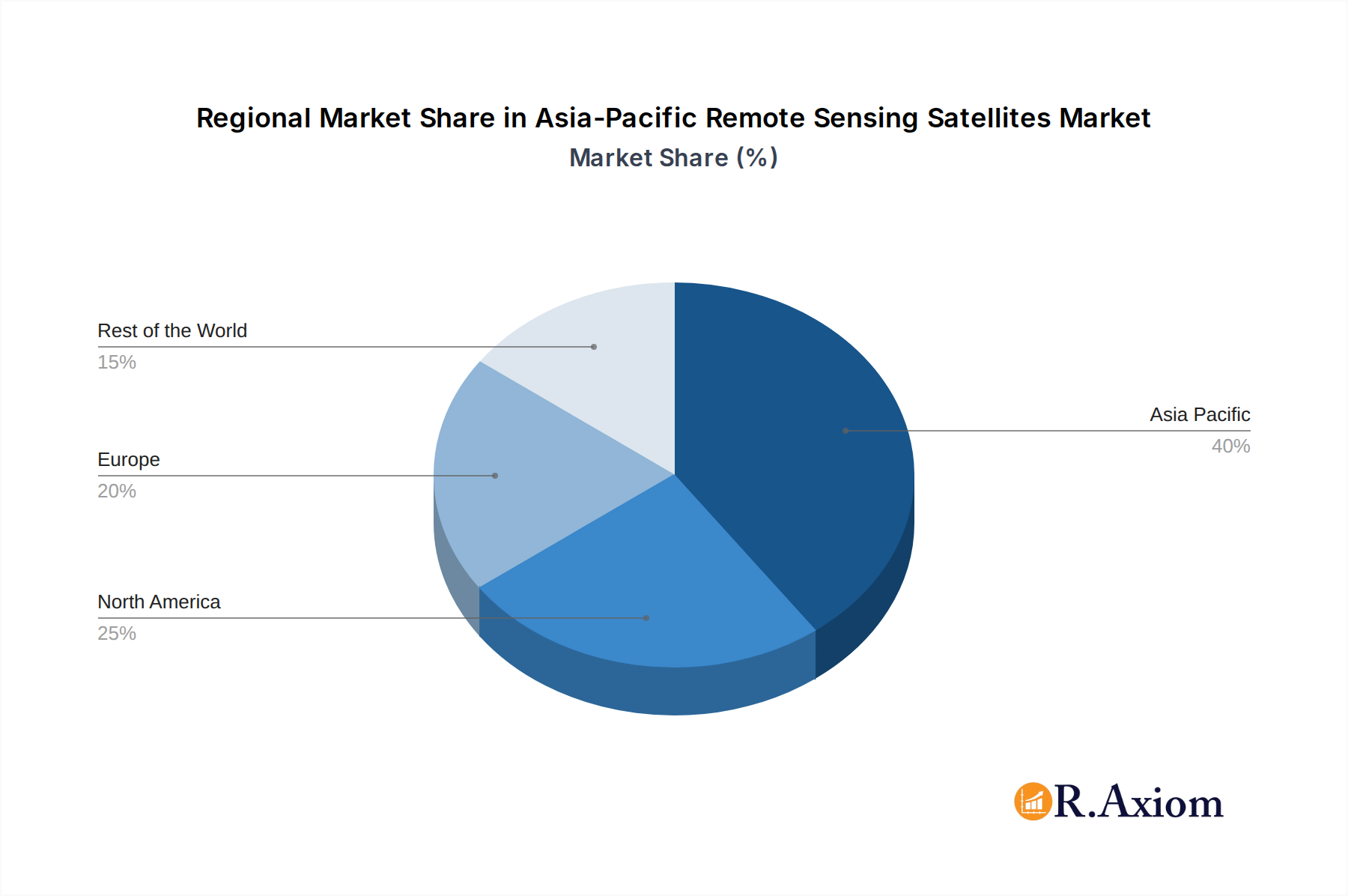
Asia-Pacific Remote Sensing Satellites Market Regional Market Share
Geographic Coverage of Asia-Pacific Remote Sensing Satellites Market
Asia-Pacific Remote Sensing Satellites Market REPORT HIGHLIGHTS
| Aspects | Details |
|---|---|
| Study Period | 2020-2034 |
| Base Year | 2025 |
| Estimated Year | 2026 |
| Forecast Period | 2026-2034 |
| Historical Period | 2020-2025 |
| Growth Rate | CAGR of 12.7% from 2020-2034 |
| Segmentation |
|
Table of Contents
- 1. Introduction
- 1.1. Research Scope
- 1.2. Market Segmentation
- 1.3. Research Objective
- 1.4. Definitions and Assumptions
- 2. Executive Summary
- 2.1. Market Snapshot
- 3. Market Dynamics
- 3.1. Market Drivers
- 3.2. Market Restrains
- 3.3. Market Trends
- 3.4. Market Opportunities
- 4. Market Factor Analysis
- 4.1. Porters Five Forces
- 4.1.1. Bargaining Power of Suppliers
- 4.1.2. Bargaining Power of Buyers
- 4.1.3. Threat of New Entrants
- 4.1.4. Threat of Substitutes
- 4.1.5. Competitive Rivalry
- 4.2. PESTEL analysis
- 4.3. BCG Analysis
- 4.3.1. Stars (High Growth, High Market Share)
- 4.3.2. Cash Cows (Low Growth, High Market Share)
- 4.3.3. Question Mark (High Growth, Low Market Share)
- 4.3.4. Dogs (Low Growth, Low Market Share)
- 4.4. Ansoff Matrix Analysis
- 4.5. Supply Chain Analysis
- 4.6. Regulatory Landscape
- 4.7. Current Market Potential and Opportunity Assessment (TAM–SAM–SOM Framework)
- 4.8. RAX Analyst Note
- 4.1. Porters Five Forces
- 5. Market Analysis, Insights and Forecast 2021-2033
- 5.1. Market Analysis, Insights and Forecast - by Satellite Mass
- 5.1.1. 10-100kg
- 5.1.2. 100-500kg
- 5.1.3. 500-1000kg
- 5.1.4. Below 10 Kg
- 5.1.5. above 1000kg
- 5.2. Market Analysis, Insights and Forecast - by Orbit Class
- 5.2.1. GEO
- 5.2.2. LEO
- 5.2.3. MEO
- 5.3. Market Analysis, Insights and Forecast - by Satellite Subsystem
- 5.3.1. Propulsion Hardware and Propellant
- 5.3.2. Satellite Bus & Subsystems
- 5.3.3. Solar Array & Power Hardware
- 5.3.4. Structures, Harness & Mechanisms
- 5.4. Market Analysis, Insights and Forecast - by End User
- 5.4.1. Commercial
- 5.4.2. Military & Government
- 5.4.3. Other
- 5.5. Market Analysis, Insights and Forecast - by Region
- 5.5.1. Asia Pacific
- 5.1. Market Analysis, Insights and Forecast - by Satellite Mass
- 6. Asia-Pacific Remote Sensing Satellites Market Analysis, Insights and Forecast, 2021-2033
- 6.1. Market Analysis, Insights and Forecast - by Satellite Mass
- 6.1.1. 10-100kg
- 6.1.2. 100-500kg
- 6.1.3. 500-1000kg
- 6.1.4. Below 10 Kg
- 6.1.5. above 1000kg
- 6.2. Market Analysis, Insights and Forecast - by Orbit Class
- 6.2.1. GEO
- 6.2.2. LEO
- 6.2.3. MEO
- 6.3. Market Analysis, Insights and Forecast - by Satellite Subsystem
- 6.3.1. Propulsion Hardware and Propellant
- 6.3.2. Satellite Bus & Subsystems
- 6.3.3. Solar Array & Power Hardware
- 6.3.4. Structures, Harness & Mechanisms
- 6.4. Market Analysis, Insights and Forecast - by End User
- 6.4.1. Commercial
- 6.4.2. Military & Government
- 6.4.3. Other
- 6.1. Market Analysis, Insights and Forecast - by Satellite Mass
- 7. Competitive Analysis
- 7.1. Company Profiles
- 7.1.1 ImageSat International
- 7.1.1.1. Company Overview
- 7.1.1.2. Products
- 7.1.1.3. Company Financials
- 7.1.1.4. SWOT Analysis
- 7.1.2 GomSpaceApS
- 7.1.2.1. Company Overview
- 7.1.2.2. Products
- 7.1.2.3. Company Financials
- 7.1.2.4. SWOT Analysis
- 7.1.3 Esri
- 7.1.3.1. Company Overview
- 7.1.3.2. Products
- 7.1.3.3. Company Financials
- 7.1.3.4. SWOT Analysis
- 7.1.4 Mitsubishi Heavy Industries
- 7.1.4.1. Company Overview
- 7.1.4.2. Products
- 7.1.4.3. Company Financials
- 7.1.4.4. SWOT Analysis
- 7.1.5 Lockheed Martin Corporation
- 7.1.5.1. Company Overview
- 7.1.5.2. Products
- 7.1.5.3. Company Financials
- 7.1.5.4. SWOT Analysis
- 7.1.6 Korea Aerospace Research Institute (KARI)
- 7.1.6.1. Company Overview
- 7.1.6.2. Products
- 7.1.6.3. Company Financials
- 7.1.6.4. SWOT Analysis
- 7.1.7 Airbus SE
- 7.1.7.1. Company Overview
- 7.1.7.2. Products
- 7.1.7.3. Company Financials
- 7.1.7.4. SWOT Analysis
- 7.1.8 Axelspace Corporation
- 7.1.8.1. Company Overview
- 7.1.8.2. Products
- 7.1.8.3. Company Financials
- 7.1.8.4. SWOT Analysis
- 7.1.9 Japan Aerospace Exploration Agency (JAXA)
- 7.1.9.1. Company Overview
- 7.1.9.2. Products
- 7.1.9.3. Company Financials
- 7.1.9.4. SWOT Analysis
- 7.1.10 China Aerospace Science and Technology Corporation (CASC)
- 7.1.10.1. Company Overview
- 7.1.10.2. Products
- 7.1.10.3. Company Financials
- 7.1.10.4. SWOT Analysis
- 7.1.11 Maxar Technologies Inc
- 7.1.11.1. Company Overview
- 7.1.11.2. Products
- 7.1.11.3. Company Financials
- 7.1.11.4. SWOT Analysis
- 7.1.12 Chang Guang Satellite Technology Co Ltd
- 7.1.12.1. Company Overview
- 7.1.12.2. Products
- 7.1.12.3. Company Financials
- 7.1.12.4. SWOT Analysis
- 7.1.13 IHI Corp
- 7.1.13.1. Company Overview
- 7.1.13.2. Products
- 7.1.13.3. Company Financials
- 7.1.13.4. SWOT Analysis
- 7.1.14 Thale
- 7.1.14.1. Company Overview
- 7.1.14.2. Products
- 7.1.14.3. Company Financials
- 7.1.14.4. SWOT Analysis
- 7.1.15 Planet Labs Inc
- 7.1.15.1. Company Overview
- 7.1.15.2. Products
- 7.1.15.3. Company Financials
- 7.1.15.4. SWOT Analysis
- 7.1.16 Northrop Grumman Corporation
- 7.1.16.1. Company Overview
- 7.1.16.2. Products
- 7.1.16.3. Company Financials
- 7.1.16.4. SWOT Analysis
- 7.1.17 Indian Space Research Organisation (ISRO)
- 7.1.17.1. Company Overview
- 7.1.17.2. Products
- 7.1.17.3. Company Financials
- 7.1.17.4. SWOT Analysis
- 7.1.18 Spire Global Inc
- 7.1.18.1. Company Overview
- 7.1.18.2. Products
- 7.1.18.3. Company Financials
- 7.1.18.4. SWOT Analysis
- 7.1.1 ImageSat International
- 7.2. Market Entropy
- 7.2.1 Company's Key Areas Served
- 7.2.2 Recent Developments
- 7.3. Company Market Share Analysis 2025
- 7.3.1 Top 5 Companies Market Share Analysis
- 7.3.2 Top 3 Companies Market Share Analysis
- 7.4. List of Potential Customers
- 8. Research Methodology
List of Figures
- Figure 1: Asia-Pacific Remote Sensing Satellites Market Revenue Breakdown (million, %) by Product 2025 & 2033
- Figure 2: Asia-Pacific Remote Sensing Satellites Market Share (%) by Company 2025
List of Tables
- Table 1: Asia-Pacific Remote Sensing Satellites Market Revenue million Forecast, by Satellite Mass 2020 & 2033
- Table 2: Asia-Pacific Remote Sensing Satellites Market Revenue million Forecast, by Orbit Class 2020 & 2033
- Table 3: Asia-Pacific Remote Sensing Satellites Market Revenue million Forecast, by Satellite Subsystem 2020 & 2033
- Table 4: Asia-Pacific Remote Sensing Satellites Market Revenue million Forecast, by End User 2020 & 2033
- Table 5: Asia-Pacific Remote Sensing Satellites Market Revenue million Forecast, by Region 2020 & 2033
- Table 6: Asia-Pacific Remote Sensing Satellites Market Revenue million Forecast, by Satellite Mass 2020 & 2033
- Table 7: Asia-Pacific Remote Sensing Satellites Market Revenue million Forecast, by Orbit Class 2020 & 2033
- Table 8: Asia-Pacific Remote Sensing Satellites Market Revenue million Forecast, by Satellite Subsystem 2020 & 2033
- Table 9: Asia-Pacific Remote Sensing Satellites Market Revenue million Forecast, by End User 2020 & 2033
- Table 10: Asia-Pacific Remote Sensing Satellites Market Revenue million Forecast, by Country 2020 & 2033
- Table 11: China Asia-Pacific Remote Sensing Satellites Market Revenue (million) Forecast, by Application 2020 & 2033
- Table 12: Japan Asia-Pacific Remote Sensing Satellites Market Revenue (million) Forecast, by Application 2020 & 2033
- Table 13: South Korea Asia-Pacific Remote Sensing Satellites Market Revenue (million) Forecast, by Application 2020 & 2033
- Table 14: India Asia-Pacific Remote Sensing Satellites Market Revenue (million) Forecast, by Application 2020 & 2033
- Table 15: Australia Asia-Pacific Remote Sensing Satellites Market Revenue (million) Forecast, by Application 2020 & 2033
- Table 16: New Zealand Asia-Pacific Remote Sensing Satellites Market Revenue (million) Forecast, by Application 2020 & 2033
- Table 17: Indonesia Asia-Pacific Remote Sensing Satellites Market Revenue (million) Forecast, by Application 2020 & 2033
- Table 18: Malaysia Asia-Pacific Remote Sensing Satellites Market Revenue (million) Forecast, by Application 2020 & 2033
- Table 19: Singapore Asia-Pacific Remote Sensing Satellites Market Revenue (million) Forecast, by Application 2020 & 2033
- Table 20: Thailand Asia-Pacific Remote Sensing Satellites Market Revenue (million) Forecast, by Application 2020 & 2033
- Table 21: Vietnam Asia-Pacific Remote Sensing Satellites Market Revenue (million) Forecast, by Application 2020 & 2033
- Table 22: Philippines Asia-Pacific Remote Sensing Satellites Market Revenue (million) Forecast, by Application 2020 & 2033
Frequently Asked Questions
1. What is the projected Compound Annual Growth Rate (CAGR) of the Asia-Pacific Remote Sensing Satellites Market?
The projected CAGR is approximately 12.7%.
2. Which companies are prominent players in the Asia-Pacific Remote Sensing Satellites Market?
Key companies in the market include ImageSat International, GomSpaceApS, Esri, Mitsubishi Heavy Industries, Lockheed Martin Corporation, Korea Aerospace Research Institute (KARI), Airbus SE, Axelspace Corporation, Japan Aerospace Exploration Agency (JAXA), China Aerospace Science and Technology Corporation (CASC), Maxar Technologies Inc, Chang Guang Satellite Technology Co Ltd, IHI Corp, Thale, Planet Labs Inc, Northrop Grumman Corporation, Indian Space Research Organisation (ISRO), Spire Global Inc.
3. What are the main segments of the Asia-Pacific Remote Sensing Satellites Market?
The market segments include Satellite Mass, Orbit Class, Satellite Subsystem, End User.
4. Can you provide details about the market size?
The market size is estimated to be USD 6654.7 million as of 2022.
5. What are some drivers contributing to market growth?
N/A
6. What are the notable trends driving market growth?
OTHER KEY INDUSTRY TRENDS COVERED IN THE REPORT.
7. Are there any restraints impacting market growth?
N/A
8. Can you provide examples of recent developments in the market?
March 2023: The Japan Aerospace Exploration Agency (JAXA) had scheduled the launch of the first H3 Launch Vehicle with the Advanced Land Observing Satellite "Daichi 3" (ALOS-3) onboard from the Tanegashima Space Center.February 2023: NASA and geographic information service provider Esri will grant wider access to the space agency's geospatial content for research and exploration purposes through the Space Act Agreement.January 2023: Axelspace announced an agreement with NorthStar Earth & Space Inc. Through this partnership, Axelspace will utilize five AxelGlobe Earth observation satellites, GRUS, to provide complementary satellite imaging data for NorthStar's space situational awareness (SSA) efforts.
9. What pricing options are available for accessing the report?
Pricing options include single-user, multi-user, and enterprise licenses priced at USD 3800, USD 4500, and USD 5800 respectively.
10. Is the market size provided in terms of value or volume?
The market size is provided in terms of value, measured in million.
11. Are there any specific market keywords associated with the report?
Yes, the market keyword associated with the report is "Asia-Pacific Remote Sensing Satellites Market," which aids in identifying and referencing the specific market segment covered.
12. How do I determine which pricing option suits my needs best?
The pricing options vary based on user requirements and access needs. Individual users may opt for single-user licenses, while businesses requiring broader access may choose multi-user or enterprise licenses for cost-effective access to the report.
13. Are there any additional resources or data provided in the Asia-Pacific Remote Sensing Satellites Market report?
While the report offers comprehensive insights, it's advisable to review the specific contents or supplementary materials provided to ascertain if additional resources or data are available.
14. How can I stay updated on further developments or reports in the Asia-Pacific Remote Sensing Satellites Market?
To stay informed about further developments, trends, and reports in the Asia-Pacific Remote Sensing Satellites Market, consider subscribing to industry newsletters, following relevant companies and organizations, or regularly checking reputable industry news sources and publications.
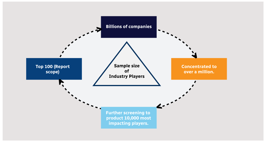
Methodology
Step 1 - Identification of Relevant Samples Size from Population Database
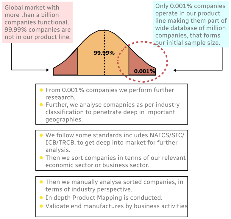
Step 2 - Approaches for Defining Global Market Size (Value, Volume* & Price*)
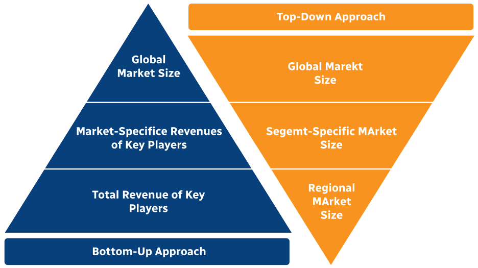
Note*: In applicable scenarios
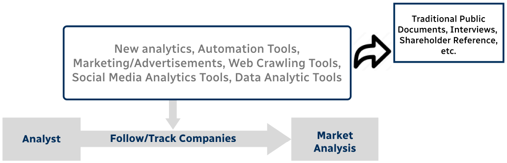
Step 3 - Data Sources
Primary Research
- Web Analytics
- Survey Reports
- Research Institute
- Latest Research Reports
- Opinion Leaders
Secondary Research
- Annual Reports
- White Paper
- Latest Press Release
- Industry Association
- Paid Database
- Investor Presentations
Step 4 - Data Triangulation
Involves using different sources of information in order to increase the validity of a study
These sources are likely to be stakeholders in a program - participants, other researchers, program staff, other community members, and so on.
Then we put all data in single framework & apply various statistical tools to find out the dynamic on the market.
During the analysis stage, feedback from the stakeholder groups would be compared to determine areas of agreement as well as areas of divergence