

Key Insights
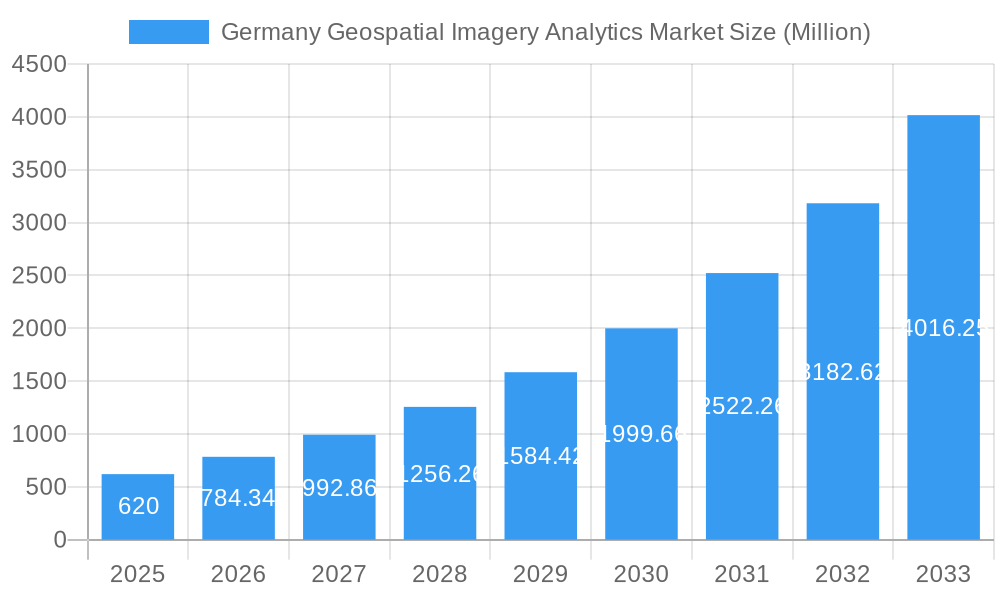
The German Geospatial Imagery Analytics market is experiencing robust growth, projected to reach €0.62 billion in 2025 and exhibiting a Compound Annual Growth Rate (CAGR) of 26.77% from 2025 to 2033. This expansion is fueled by several key drivers. The increasing adoption of precision agriculture techniques necessitates detailed land analysis, driving demand for geospatial imagery. Furthermore, urban planning and infrastructure development projects in Germany rely heavily on accurate geospatial data for efficient resource allocation and risk mitigation. The rising prevalence of smart city initiatives further fuels market growth, as these initiatives depend on real-time data analysis derived from geospatial imagery for optimized resource management and citizen services. Government investments in infrastructure modernization and digitalization are also contributing factors. While data privacy concerns and the high cost of advanced analytics solutions might pose some restraints, the overall market outlook remains exceptionally positive, driven by the ongoing digital transformation and the increasing reliance on data-driven decision-making across various sectors.
Germany Geospatial Imagery Analytics Market Market Size (In Million)
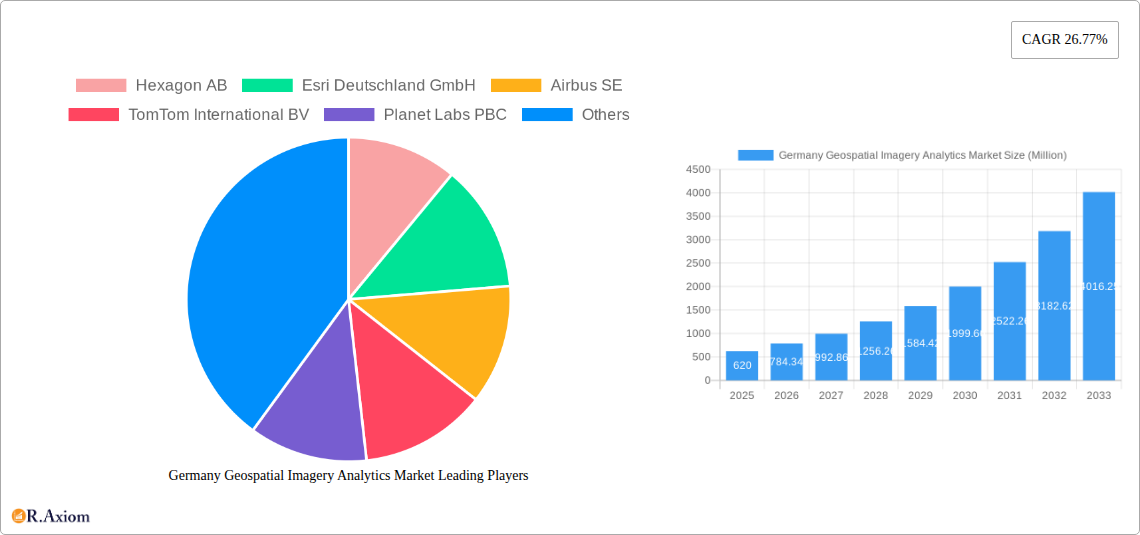
The competitive landscape is marked by a mix of established international players and specialized German firms. Companies like Hexagon AB, Esri Deutschland GmbH, Airbus SE, and TomTom International BV are leveraging their technological expertise to capture significant market share. The presence of local companies alongside multinational corporations ensures a dynamic market environment with diverse solutions and service offerings. Future growth will likely be driven by innovations in areas such as AI-powered image analysis, the integration of IoT devices for real-time data acquisition, and the development of cloud-based geospatial analytics platforms. The market is expected to see an increased adoption of advanced analytics techniques, such as deep learning and machine learning, leading to more sophisticated and accurate insights from geospatial imagery. This will, in turn, result in improved decision-making across various sectors, further accelerating market growth.
Germany Geospatial Imagery Analytics Market Company Market Share
This detailed report provides a comprehensive analysis of the Germany Geospatial Imagery Analytics Market, offering invaluable insights for stakeholders, investors, and industry professionals. The study period covers 2019-2033, with 2025 as the base and estimated year, and a forecast period of 2025-2033. The historical period analyzed is 2019-2024. The market is experiencing significant growth driven by technological advancements, increasing demand across diverse sectors, and supportive government initiatives. This report offers actionable intelligence on market size, segmentation, key players, and future trends.
Germany Geospatial Imagery Analytics Market Market Concentration & Innovation
The German geospatial imagery analytics market is characterized by a moderately concentrated competitive landscape, where a few dominant companies hold substantial market shares. Key players like Hexagon AB, Esri Deutschland GmbH, and Airbus SE are expected to collectively command an estimated [XX]% of the market by 2025. This dominance is balanced by the presence of numerous specialized firms and agile emerging players, fostering a dynamic and competitive environment. Innovation is a pivotal growth engine, propelled by rapid advancements in artificial intelligence (AI), machine learning (ML), cloud computing, and sophisticated sensor technologies. These technological leaps are leading to significant improvements in data processing efficiency, the generation of deeper analytical insights, and the creation of novel applications across a diverse range of industries. Regulatory frameworks, particularly stringent data privacy regulations like the GDPR, play a crucial role in shaping market practices and influencing innovation strategies. The market also experiences consistent merger and acquisition (M&A) activity, with deal values estimated to be in the range of [XX] Million annually, reflecting strategic consolidations and acquisitions aimed at expanding capabilities and market reach. End-user preferences are increasingly gravitating towards solutions that offer enhanced automation, seamless integration, and intuitive user experiences.
- Market Share (2025 Estimate):
- Hexagon AB: [XX]%
- Esri Deutschland GmbH: [XX]%
- Airbus SE: [XX]%
- Others: [XX]%
- M&A Activity (2019-2024): An estimated [XX] deals with a total value of [XX] Million.
- Key Innovation Drivers: Advanced AI and Machine Learning algorithms, scalable Cloud Computing platforms, High-Resolution Satellite and Aerial Imagery, and cutting-edge Sensor Technology.
Germany Geospatial Imagery Analytics Market Industry Trends & Insights
The German geospatial imagery analytics market is on a trajectory for substantial growth, with a projected Compound Annual Growth Rate (CAGR) of [XX]% anticipated between 2025 and 2033. This impressive expansion is underpinned by a confluence of driving forces. Significant government investments in large-scale infrastructure projects are creating demand for sophisticated planning and monitoring tools. The increasing adoption of precision agriculture techniques is revolutionizing farming practices, requiring detailed geospatial data. Furthermore, the growing need for efficient urban planning solutions and the critical importance of environmental monitoring and effective disaster management are also contributing factors. Technological advancements, such as the widespread deployment of Unmanned Aerial Vehicles (UAVs) and the expanding availability of high-resolution satellite imagery, are acting as significant catalysts for market growth. User preferences are actively shifting towards cloud-based solutions and flexible, scalable platforms that offer improved accessibility and cost-effectiveness. The competitive landscape is dynamic, characterized by a blend of strategic collaborations and intense competition, with leading companies making substantial investments in research and development (R&D) and forging strategic partnerships to solidify their market positions. Market penetration is most pronounced in densely populated urban areas and in sectors with high data requirements, with a penetration rate of [XX]% in 2025, projected to rise to [XX]% by 2033.
Dominant Markets & Segments in Germany Geospatial Imagery Analytics Market
The dominant market segment within the German geospatial imagery analytics market is the urban planning and infrastructure sector. This segment accounts for the largest share of market revenue due to the high demand for accurate and timely geospatial data for city planning, transportation management, and utility infrastructure optimization. Key drivers for this dominance include:
- Robust Urban Infrastructure: Germany has well-developed urban infrastructure which requires constant monitoring and management.
- Government Investments: Significant government investments in urban development and smart city initiatives fuel demand for advanced analytics.
- Stringent Regulations: Environmental regulations drive the adoption of geospatial analytics for sustainable urban planning.
- Technological Advancements: The availability of high-resolution imagery and advanced analytic tools makes the technology more accessible and efficient.
Further analysis demonstrates the consistent growth across sectors, with agriculture, environmental monitoring, and defense following closely. The South and West regions of Germany show higher market penetration than the East due to higher economic activity and adoption of innovative technologies.
Germany Geospatial Imagery Analytics Market Product Developments
Recent product innovations focus on integrating AI and machine learning to automate data analysis, improve accuracy, and offer more comprehensive insights. New applications are emerging in areas such as precision agriculture, disaster response, and environmental monitoring. Competitive advantages are gained through superior data processing speeds, higher accuracy, user-friendly interfaces, and the ability to integrate with other enterprise systems. The market is witnessing a shift towards cloud-based solutions offering scalability and cost-effectiveness.
Report Scope & Segmentation Analysis
This comprehensive report segments the Germany Geospatial Imagery Analytics Market based on a granular analysis of key differentiating factors:
By Component: This segmentation categorizes the market into Software solutions and various Services, including expert consulting, seamless implementation, and dedicated technical support.
By Deployment Mode: The market is analyzed based on deployment preferences, encompassing flexible Cloud-based solutions and traditional On-premise installations.
By End-User: This segmentation identifies the primary sectors driving demand, including Government agencies, the Defense sector, Agriculture, Urban Planning departments, and the Utilities industry.
For each meticulously defined segment, the report provides detailed market size estimations and future growth projections. It also offers insights into how competitive dynamics vary across these segments, highlighting specific players that have established expertise and leadership in particular niche areas.
Key Drivers of Germany Geospatial Imagery Analytics Market Growth
The growth of the German geospatial imagery analytics market is propelled by several key factors:
- Technological Advancements: AI, machine learning, and high-resolution imagery improve analysis speed and accuracy.
- Government Initiatives: Investments in infrastructure projects and smart city initiatives increase demand for geospatial data.
- Increasing Data Availability: Improved satellite imagery and sensor technology provide more data for analysis.
- Rising Environmental Concerns: The need for environmental monitoring and sustainability initiatives fuels market growth.
Challenges in the Germany Geospatial Imagery Analytics Market Sector
Despite the promising growth outlook, the Germany Geospatial Imagery Analytics Market faces several notable challenges that could impede its expansion:
- Data Privacy Regulations: Strict adherence to GDPR compliance presents significant hurdles in the collection, processing, and utilization of sensitive geospatial data, requiring robust data governance strategies.
- High Initial Investment Costs: The implementation of advanced geospatial imagery analytics systems often necessitates substantial upfront capital investment, which can be a barrier for smaller organizations or those with limited budgets.
- Data Security Concerns: Protecting vast amounts of sensitive geospatial information from unauthorized access, cyber threats, and data breaches is a paramount concern that requires continuous vigilance and sophisticated security measures.
- Skill Shortages: A persistent shortage of highly skilled professionals with expertise in operating, analyzing, and maintaining advanced geospatial systems directly impacts market growth by delaying project implementations and limiting the adoption of cutting-edge technologies.
Emerging Opportunities in Germany Geospatial Imagery Analytics Market
Emerging opportunities exist in several areas:
- 3D City Modeling: Increasing adoption of 3D city models for urban planning and infrastructure management.
- IoT Integration: Combining geospatial data with IoT data for real-time monitoring and insights.
- Autonomous Vehicles: Development of geospatial solutions for autonomous vehicle navigation and management.
- Precision Agriculture: Use of geospatial analytics for optimizing crop yields and resource management.
Leading Players in the Germany Geospatial Imagery Analytics Market Market
Key Developments in Germany Geospatial Imagery Analytics Market Industry
- September 2023: European Space Imaging (EUSI) partnered with Umbra to increase SAR data availability in Germany.
- January 2024: LiveEO launched its EUDR Expert AI compliance advisor solution.
Strategic Outlook for Germany Geospatial Imagery Analytics Market Market
The German geospatial imagery analytics market is well-positioned for sustained and robust growth, fueled by relentless technological innovation, an ever-increasing volume of readily available geospatial data, and burgeoning demand across a wide spectrum of industries. Future growth opportunities are concentrated in the seamless integration of emerging technologies such as advanced AI, the Internet of Things (IoT), and sophisticated cloud computing architectures to develop more intelligent, predictive, and user-friendly analytical solutions. The market is likely to witness further consolidation through strategic mergers and acquisitions, leading to a more concentrated, yet highly innovative, industry landscape. Companies that can adeptly leverage these transformative technologies and proactively adapt to evolving regulatory environments will undoubtedly be the frontrunners, poised for significant success within this dynamic and rapidly expanding market.
Germany Geospatial Imagery Analytics Market Segmentation
-
1. Type
- 1.1. Imagery Analytics
- 1.2. Video Analytics
-
2. Deployment Mode
- 2.1. On-premise
- 2.2. Cloud
-
3. Organization Size
- 3.1. SMEs
- 3.2. Large Enterprises
-
4. Verticals
- 4.1. Insurance
- 4.2. Agriculture
- 4.3. Defense and Security
- 4.4. Environmental Monitoring
- 4.5. Engineering and Construction
- 4.6. Government
- 4.7. Other Verticals
Germany Geospatial Imagery Analytics Market Segmentation By Geography
- 1. Germany
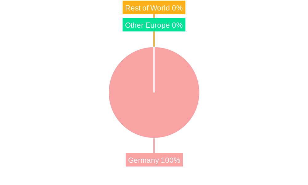
Germany Geospatial Imagery Analytics Market Regional Market Share
Geographic Coverage of Germany Geospatial Imagery Analytics Market
Germany Geospatial Imagery Analytics Market REPORT HIGHLIGHTS
| Aspects | Details |
|---|---|
| Study Period | 2020-2034 |
| Base Year | 2025 |
| Estimated Year | 2026 |
| Forecast Period | 2026-2034 |
| Historical Period | 2020-2025 |
| Growth Rate | CAGR of 26.77% from 2020-2034 |
| Segmentation |
|
Table of Contents
- 1. Introduction
- 1.1. Research Scope
- 1.2. Market Segmentation
- 1.3. Research Objective
- 1.4. Definitions and Assumptions
- 2. Executive Summary
- 2.1. Market Snapshot
- 3. Market Dynamics
- 3.1. Market Drivers
- 3.2. Market Restrains
- 3.3. Market Trends
- 3.4. Market Opportunities
- 4. Market Factor Analysis
- 4.1. Porters Five Forces
- 4.1.1. Bargaining Power of Suppliers
- 4.1.2. Bargaining Power of Buyers
- 4.1.3. Threat of New Entrants
- 4.1.4. Threat of Substitutes
- 4.1.5. Competitive Rivalry
- 4.2. PESTEL analysis
- 4.3. BCG Analysis
- 4.3.1. Stars (High Growth, High Market Share)
- 4.3.2. Cash Cows (Low Growth, High Market Share)
- 4.3.3. Question Mark (High Growth, Low Market Share)
- 4.3.4. Dogs (Low Growth, Low Market Share)
- 4.4. Ansoff Matrix Analysis
- 4.5. Supply Chain Analysis
- 4.6. Regulatory Landscape
- 4.7. Current Market Potential and Opportunity Assessment (TAM–SAM–SOM Framework)
- 4.8. RAX Analyst Note
- 4.1. Porters Five Forces
- 5. Market Analysis, Insights and Forecast 2021-2033
- 5.1. Market Analysis, Insights and Forecast - by Type
- 5.1.1. Imagery Analytics
- 5.1.2. Video Analytics
- 5.2. Market Analysis, Insights and Forecast - by Deployment Mode
- 5.2.1. On-premise
- 5.2.2. Cloud
- 5.3. Market Analysis, Insights and Forecast - by Organization Size
- 5.3.1. SMEs
- 5.3.2. Large Enterprises
- 5.4. Market Analysis, Insights and Forecast - by Verticals
- 5.4.1. Insurance
- 5.4.2. Agriculture
- 5.4.3. Defense and Security
- 5.4.4. Environmental Monitoring
- 5.4.5. Engineering and Construction
- 5.4.6. Government
- 5.4.7. Other Verticals
- 5.5. Market Analysis, Insights and Forecast - by Region
- 5.5.1. Germany
- 5.1. Market Analysis, Insights and Forecast - by Type
- 6. Germany Geospatial Imagery Analytics Market Analysis, Insights and Forecast, 2021-2033
- 6.1. Market Analysis, Insights and Forecast - by Type
- 6.1.1. Imagery Analytics
- 6.1.2. Video Analytics
- 6.2. Market Analysis, Insights and Forecast - by Deployment Mode
- 6.2.1. On-premise
- 6.2.2. Cloud
- 6.3. Market Analysis, Insights and Forecast - by Organization Size
- 6.3.1. SMEs
- 6.3.2. Large Enterprises
- 6.4. Market Analysis, Insights and Forecast - by Verticals
- 6.4.1. Insurance
- 6.4.2. Agriculture
- 6.4.3. Defense and Security
- 6.4.4. Environmental Monitoring
- 6.4.5. Engineering and Construction
- 6.4.6. Government
- 6.4.7. Other Verticals
- 6.1. Market Analysis, Insights and Forecast - by Type
- 7. Competitive Analysis
- 7.1. Company Profiles
- 7.1.1 Hexagon AB
- 7.1.1.1. Company Overview
- 7.1.1.2. Products
- 7.1.1.3. Company Financials
- 7.1.1.4. SWOT Analysis
- 7.1.2 Esri Deutschland GmbH
- 7.1.2.1. Company Overview
- 7.1.2.2. Products
- 7.1.2.3. Company Financials
- 7.1.2.4. SWOT Analysis
- 7.1.3 Airbus SE
- 7.1.3.1. Company Overview
- 7.1.3.2. Products
- 7.1.3.3. Company Financials
- 7.1.3.4. SWOT Analysis
- 7.1.4 TomTom International BV
- 7.1.4.1. Company Overview
- 7.1.4.2. Products
- 7.1.4.3. Company Financials
- 7.1.4.4. SWOT Analysis
- 7.1.5 Planet Labs PBC
- 7.1.5.1. Company Overview
- 7.1.5.2. Products
- 7.1.5.3. Company Financials
- 7.1.5.4. SWOT Analysis
- 7.1.6 Oracle Corporation
- 7.1.6.1. Company Overview
- 7.1.6.2. Products
- 7.1.6.3. Company Financials
- 7.1.6.4. SWOT Analysis
- 7.1.7 BAE Systems
- 7.1.7.1. Company Overview
- 7.1.7.2. Products
- 7.1.7.3. Company Financials
- 7.1.7.4. SWOT Analysis
- 7.1.8 Maxar Technologies
- 7.1.8.1. Company Overview
- 7.1.8.2. Products
- 7.1.8.3. Company Financials
- 7.1.8.4. SWOT Analysis
- 7.1.9 Microsoft Corporation
- 7.1.9.1. Company Overview
- 7.1.9.2. Products
- 7.1.9.3. Company Financials
- 7.1.9.4. SWOT Analysis
- 7.1.10 Google LLC*List Not Exhaustive
- 7.1.10.1. Company Overview
- 7.1.10.2. Products
- 7.1.10.3. Company Financials
- 7.1.10.4. SWOT Analysis
- 7.1.1 Hexagon AB
- 7.2. Market Entropy
- 7.2.1 Company's Key Areas Served
- 7.2.2 Recent Developments
- 7.3. Company Market Share Analysis 2025
- 7.3.1 Top 5 Companies Market Share Analysis
- 7.3.2 Top 3 Companies Market Share Analysis
- 7.4. List of Potential Customers
- 8. Research Methodology
List of Figures
- Figure 1: Germany Geospatial Imagery Analytics Market Revenue Breakdown (Million, %) by Product 2025 & 2033
- Figure 2: Germany Geospatial Imagery Analytics Market Share (%) by Company 2025
List of Tables
- Table 1: Germany Geospatial Imagery Analytics Market Revenue Million Forecast, by Type 2020 & 2033
- Table 2: Germany Geospatial Imagery Analytics Market Volume Billion Forecast, by Type 2020 & 2033
- Table 3: Germany Geospatial Imagery Analytics Market Revenue Million Forecast, by Deployment Mode 2020 & 2033
- Table 4: Germany Geospatial Imagery Analytics Market Volume Billion Forecast, by Deployment Mode 2020 & 2033
- Table 5: Germany Geospatial Imagery Analytics Market Revenue Million Forecast, by Organization Size 2020 & 2033
- Table 6: Germany Geospatial Imagery Analytics Market Volume Billion Forecast, by Organization Size 2020 & 2033
- Table 7: Germany Geospatial Imagery Analytics Market Revenue Million Forecast, by Verticals 2020 & 2033
- Table 8: Germany Geospatial Imagery Analytics Market Volume Billion Forecast, by Verticals 2020 & 2033
- Table 9: Germany Geospatial Imagery Analytics Market Revenue Million Forecast, by Region 2020 & 2033
- Table 10: Germany Geospatial Imagery Analytics Market Volume Billion Forecast, by Region 2020 & 2033
- Table 11: Germany Geospatial Imagery Analytics Market Revenue Million Forecast, by Type 2020 & 2033
- Table 12: Germany Geospatial Imagery Analytics Market Volume Billion Forecast, by Type 2020 & 2033
- Table 13: Germany Geospatial Imagery Analytics Market Revenue Million Forecast, by Deployment Mode 2020 & 2033
- Table 14: Germany Geospatial Imagery Analytics Market Volume Billion Forecast, by Deployment Mode 2020 & 2033
- Table 15: Germany Geospatial Imagery Analytics Market Revenue Million Forecast, by Organization Size 2020 & 2033
- Table 16: Germany Geospatial Imagery Analytics Market Volume Billion Forecast, by Organization Size 2020 & 2033
- Table 17: Germany Geospatial Imagery Analytics Market Revenue Million Forecast, by Verticals 2020 & 2033
- Table 18: Germany Geospatial Imagery Analytics Market Volume Billion Forecast, by Verticals 2020 & 2033
- Table 19: Germany Geospatial Imagery Analytics Market Revenue Million Forecast, by Country 2020 & 2033
- Table 20: Germany Geospatial Imagery Analytics Market Volume Billion Forecast, by Country 2020 & 2033
Frequently Asked Questions
1. What is the projected Compound Annual Growth Rate (CAGR) of the Germany Geospatial Imagery Analytics Market?
The projected CAGR is approximately 26.77%.
2. Which companies are prominent players in the Germany Geospatial Imagery Analytics Market?
Key companies in the market include Hexagon AB, Esri Deutschland GmbH, Airbus SE, TomTom International BV, Planet Labs PBC, Oracle Corporation, BAE Systems, Maxar Technologies, Microsoft Corporation, Google LLC*List Not Exhaustive.
3. What are the main segments of the Germany Geospatial Imagery Analytics Market?
The market segments include Type, Deployment Mode, Organization Size, Verticals.
4. Can you provide details about the market size?
The market size is estimated to be USD 0.62 Million as of 2022.
5. What are some drivers contributing to market growth?
The Growth of Infrastructure Development and Urban Planning in the Country; The Growing Demand for High-resolution Satellite Data for Crisis Response. Environmental Monitoring. and Nature Conservation Efforts.
6. What are the notable trends driving market growth?
Imagery Analytics Contributes Significantly to the Market Share.
7. Are there any restraints impacting market growth?
The Growth of Infrastructure Development and Urban Planning in the Country; The Growing Demand for High-resolution Satellite Data for Crisis Response. Environmental Monitoring. and Nature Conservation Efforts.
8. Can you provide examples of recent developments in the market?
January 2024 - LiveEO, a Berlin-based Earth observation scaleup company that specializes in using AI to analyze Earth observation data in support of critical transport and energy infrastructure, launched its EUDR Expert. It is an AI compliance advisor solution that helps understand the complexities and challenges that clients face with the EU Deforestation Regulation (EUDR).
9. What pricing options are available for accessing the report?
Pricing options include single-user, multi-user, and enterprise licenses priced at USD 3800, USD 4500, and USD 5800 respectively.
10. Is the market size provided in terms of value or volume?
The market size is provided in terms of value, measured in Million and volume, measured in Billion.
11. Are there any specific market keywords associated with the report?
Yes, the market keyword associated with the report is "Germany Geospatial Imagery Analytics Market," which aids in identifying and referencing the specific market segment covered.
12. How do I determine which pricing option suits my needs best?
The pricing options vary based on user requirements and access needs. Individual users may opt for single-user licenses, while businesses requiring broader access may choose multi-user or enterprise licenses for cost-effective access to the report.
13. Are there any additional resources or data provided in the Germany Geospatial Imagery Analytics Market report?
While the report offers comprehensive insights, it's advisable to review the specific contents or supplementary materials provided to ascertain if additional resources or data are available.
14. How can I stay updated on further developments or reports in the Germany Geospatial Imagery Analytics Market?
To stay informed about further developments, trends, and reports in the Germany Geospatial Imagery Analytics Market, consider subscribing to industry newsletters, following relevant companies and organizations, or regularly checking reputable industry news sources and publications.
Methodology
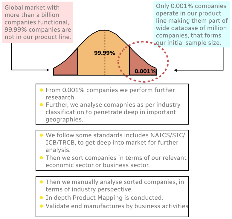
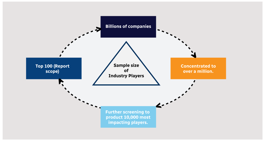
Step 1 - Identification of Relevant Samples Size from Population Database
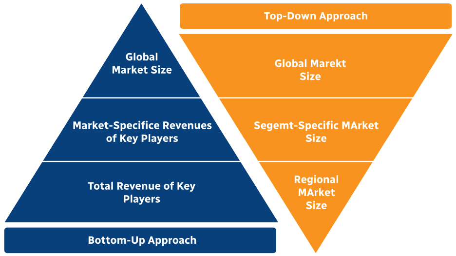
Step 2 - Approaches for Defining Global Market Size (Value, Volume* & Price*)
Note*: In applicable scenarios
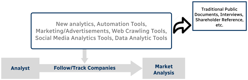
Step 3 - Data Sources
Primary Research
- Web Analytics
- Survey Reports
- Research Institute
- Latest Research Reports
- Opinion Leaders
Secondary Research
- Annual Reports
- White Paper
- Latest Press Release
- Industry Association
- Paid Database
- Investor Presentations
Step 4 - Data Triangulation
Involves using different sources of information in order to increase the validity of a study
These sources are likely to be stakeholders in a program - participants, other researchers, program staff, other community members, and so on.
Then we put all data in single framework & apply various statistical tools to find out the dynamic on the market.
During the analysis stage, feedback from the stakeholder groups would be compared to determine areas of agreement as well as areas of divergence