

Key Insights
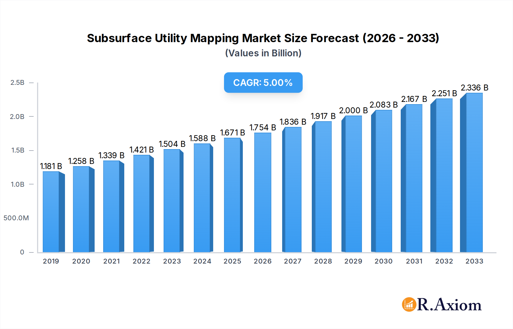
The global Subsurface Utility Mapping market is poised for significant expansion, projected to reach $1.52 billion by 2025. This growth trajectory is underpinned by a robust Compound Annual Growth Rate (CAGR) of 6.88% from 2019 to 2033, indicating sustained demand for advanced utility location and management solutions. The escalating need for accurate subsurface utility data is driven by increasing infrastructure development and modernization projects across various sectors. Factors such as the expansion of smart city initiatives, the necessity for efficient management of aging utility networks, and the growing emphasis on public safety and environmental protection are key catalysts for market expansion. The market is segmented into distinct applications including water pipelines, gas pipelines, electric cables, telecommunication, and transportation, each contributing to the overall demand. Furthermore, the evolution of technology, from traditional detection methods to advanced GPR, electromagnetic, and acoustic technologies, coupled with the integration of GIS and AI-driven analytics, is shaping the market landscape.

Subsurface Utility Mapping Market Size (In Billion)
The market's growth is further propelled by the increasing adoption of sophisticated hardware and software solutions, alongside specialized services offered by leading companies such as RETTEW, SurvTech Solutions, Inc., and Esri. These companies are at the forefront of innovation, providing comprehensive solutions for utility detection, mapping, and data management. While the market presents substantial opportunities, it also faces certain restraints, primarily stemming from the high initial investment costs for advanced mapping equipment and the need for skilled professionals to operate and interpret the data accurately. However, the growing awareness of the long-term cost savings and risk mitigation benefits associated with precise subsurface utility mapping is expected to offset these challenges. Geographically, North America, Europe, and Asia Pacific are anticipated to be key regions, driven by extensive infrastructure projects and stringent regulatory frameworks. The ongoing digital transformation in infrastructure management globally will continue to fuel demand for these critical services.
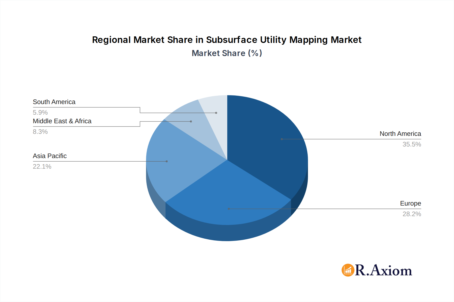
Subsurface Utility Mapping Company Market Share
Subsurface Utility Mapping Market: Comprehensive Growth Analysis and Future Projections (2019-2033)
This comprehensive report delves into the Subsurface Utility Mapping market, offering an in-depth analysis of its current landscape, historical performance, and future trajectory. Covering the study period from 2019 to 2033, with a base and estimated year of 2025, this report provides critical insights for stakeholders seeking to understand market concentration, industry trends, dominant segments, product developments, growth drivers, challenges, and emerging opportunities. Utilizing a vast dataset and advanced analytical methodologies, this report projects a robust growth trajectory for the subsurface utility mapping sector, driven by increasing infrastructure development, stringent safety regulations, and technological advancements.
Subsurface Utility Mapping Market Concentration & Innovation
The global subsurface utility mapping market exhibits a moderate level of concentration, with key players like RETTEW, SurvTech Solutions, Inc., Sensors & Software Inc., DGT Associates, Utility Mapping Services Inc., Patterson & Dewar Engineers, Inc., KCI Technologies, Esri, Accurate Infrastructure Data, Inc., GeoScan, T2 Utility Engineers, GEL Group, Inc., Underground Services, Inc., Juniper Systems Inc., Leica, Hexagon, GSSI, US Radar, Plowman Craven, Cardno, and others actively shaping its dynamics. Innovation is a primary driver, fueled by continuous advancements in Ground Penetrating Radar (GPR), electromagnetic locators, magnetic locators, and other non-destructive testing (NDT) technologies. These innovations are crucial for improving accuracy, efficiency, and safety in locating buried utilities. Regulatory frameworks, such as the "Dig Safe" laws and various governmental mandates for utility identification prior to excavation, significantly influence market adoption and demand. While direct product substitutes are limited, older, less precise methods of utility locating pose an indirect competitive challenge. End-user trends are increasingly leaning towards integrated digital solutions and Geographic Information Systems (GIS) for comprehensive data management and visualization. Mergers and acquisitions (M&A) are a notable feature, with a projected total deal value exceeding billion, indicating a consolidation trend as larger entities acquire specialized service providers or technology developers to expand their service portfolios and market reach. Companies like KCI Technologies and Cardno have been active in strategic acquisitions to bolster their capabilities.
Subsurface Utility Utility Mapping Industry Trends & Insights
The subsurface utility mapping industry is experiencing significant growth, driven by a confluence of factors that are reshaping infrastructure management and construction practices worldwide. The projected Compound Annual Growth Rate (CAGR) for the forecast period (2025–2033) is anticipated to be robust, exceeding 8.5%, translating into a market value poised to reach several billion dollars by 2033. This expansion is primarily propelled by the escalating global investments in new infrastructure projects and the imperative to maintain and upgrade existing underground utility networks, including water pipelines, gas pipelines, electric cables, and telecommunication lines. A critical trend is the increasing emphasis on safety and risk mitigation. Accidental damage to underground utilities during construction and excavation activities can lead to severe accidents, environmental damage, and substantial financial losses, often running into billions of dollars annually. This has led to stricter regulations and a greater demand for accurate subsurface utility mapping services. Technological disruptions are at the forefront of industry evolution. The integration of advanced sensor technologies, such as improved GPR systems, electromagnetic induction devices, and advanced GPS receivers, is enhancing the precision and efficiency of utility detection. Furthermore, the adoption of data analytics, artificial intelligence (AI), and cloud-based platforms is revolutionizing how utility data is collected, processed, analyzed, and managed, enabling better decision-making and predictive maintenance. Consumer preferences are shifting towards comprehensive, data-driven solutions that provide a holistic view of the underground environment. Clients are demanding integrated services that go beyond mere detection, encompassing detailed mapping, asset management, and visualization tools. Companies like Esri are playing a crucial role in providing GIS platforms that facilitate the seamless integration of utility data. Competitive dynamics are intensifying, with established players expanding their offerings and new entrants bringing innovative technologies to the market. The market penetration of advanced subsurface utility mapping techniques is steadily increasing across various sectors, from traditional infrastructure to emerging fields like renewable energy projects and smart city initiatives. The industry is also witnessing a growing demand for specialized services, such as leak detection in water pipelines and integrity assessments of gas pipelines, further diversifying the market landscape. The overall outlook is one of sustained growth and innovation, driven by the fundamental need for safe, efficient, and well-managed underground infrastructure.
Dominant Markets & Segments in Subsurface Utility Mapping
The subsurface utility mapping market is characterized by distinct regional dominance and segment penetration. North America currently leads the market, driven by extensive infrastructure development, a mature regulatory environment, and high adoption rates of advanced technologies. Within North America, the United States accounts for a significant portion of the market share, estimated to be over 40 billion, due to its vast network of aging utilities and substantial ongoing investment in infrastructure upgrades and new projects. Key drivers for this dominance include substantial government spending on transportation infrastructure, energy grid modernization, and telecommunication network expansion. Furthermore, stringent regulations regarding excavation safety and utility protection have mandated the use of professional subsurface utility mapping services, significantly boosting market penetration.
Key Drivers in North America:
- Economic Policies: Government initiatives like infrastructure bills and stimulus packages directly fund utility projects.
- Infrastructure: An aging yet extensive network of underground utilities requires constant monitoring, maintenance, and upgrades.
- Regulatory Frameworks: Mandates for utility locating before excavation (e.g., 811 "Call Before You Dig" programs) are universally enforced.
- Technological Adoption: High receptivity to advanced mapping technologies like GPR, LiDAR, and GIS integration.
The Application segment of Electric Cables is a dominant force, representing an estimated market share of over 35 billion. The increasing demand for electricity, coupled with the expansion of smart grids and renewable energy infrastructure, necessitates precise mapping of buried electric lines to prevent damage during construction and ensure grid reliability. Similarly, Gas Pipelines constitute another major segment, valued at over 30 billion, owing to the extensive natural gas distribution networks and the critical safety concerns associated with their integrity.
In terms of Types, the Service segment holds the largest market share, projected to exceed 70 billion. This is attributed to the complex nature of subsurface utility mapping, which requires specialized expertise, equipment, and software. Clients often opt for outsourcing these services to specialized firms like RETTEW, SurvTech Solutions, Inc., and T2 Utility Engineers to ensure accuracy and compliance. The Hardware segment, including GPR systems from GSSI and US Radar, and locating equipment from Sensors & Software Inc. and Leica, is also significant, valued at over 25 billion, as it forms the backbone of the mapping process. The Software segment, driven by companies like Esri and their GIS solutions, is experiencing rapid growth, valued at over 15 billion, as it enables the integration, analysis, and management of utility data.
Subsurface Utility Mapping Product Developments
Recent product developments in subsurface utility mapping are focused on enhancing accuracy, efficiency, and data integration. Innovations include multi-frequency GPR systems offering deeper penetration and clearer imaging of diverse utility types, advanced electromagnetic locators with improved signal-to-noise ratios for complex underground environments, and integrated hardware-software solutions that streamline data acquisition and processing. Companies like GSSI and US Radar are pushing the boundaries of GPR technology, while Hexagon and Leica are developing sophisticated surveying and mapping instruments. These advancements provide competitive advantages by reducing survey time, minimizing excavation risks, and enabling comprehensive digital twin creation for underground infrastructure.
Report Scope & Segmentation Analysis
This report provides an exhaustive analysis of the subsurface utility mapping market, segmented across key applications and types. The Application segments include Water Pipelines, Gas Pipelines, Electric Cables, Telecommunication, Transportation, and Others. Each segment's market size and projected growth rates have been meticulously analyzed, with Electric Cables and Gas Pipelines expected to exhibit the highest growth due to infrastructure upgrades and safety mandates, reaching projected market sizes of over 40 billion and 35 billion respectively by 2033.
The Types segmentation covers Service, Hardware, and Software. The Service segment, comprising utility locating, surveying, and data management, is the largest, predicted to surpass 75 billion by 2033, reflecting the demand for expert solutions. The Hardware segment, encompassing GPR, electromagnetic locators, and other detection equipment, is projected to reach over 30 billion, driven by technological advancements. The Software segment, including GIS platforms and data analytics tools, is rapidly expanding, expected to exceed 20 billion, as integrated digital solutions become indispensable.
Key Drivers of Subsurface Utility Mapping Growth
The subsurface utility mapping sector is propelled by a trifecta of technological advancements, economic imperatives, and regulatory enforcement. The relentless evolution of GPR, electromagnetic, and magnetic locating technologies, offering greater accuracy and efficiency, is a primary catalyst. Economically, substantial global investments in infrastructure development and the critical need to maintain aging underground utility networks, estimated to require trillions of dollars in upgrades, create sustained demand. Regulatory frameworks, such as mandatory utility locating before excavation to prevent damages and ensure public safety, are increasingly stringent worldwide, directly driving market adoption and the need for professional services.
Challenges in the Subsurface Utility Mapping Sector
Despite its robust growth, the subsurface utility mapping sector faces several challenges. The complexity of varied soil conditions and the presence of multiple overlapping utilities can hinder accurate detection, impacting precision and increasing project timelines. Fluctuations in the cost of advanced hardware and specialized software can present a barrier to entry for smaller firms, while the availability of skilled technicians and data analysts remains a concern. Furthermore, the need for continuous compliance with evolving regulatory standards and the pressure to maintain competitive pricing in a growing but fragmented market present ongoing strategic challenges for businesses in this sector.
Emerging Opportunities in Subsurface Utility Mapping
Emerging opportunities in the subsurface utility mapping market are abundant and diverse. The expansion of smart city initiatives worldwide creates a significant demand for comprehensive underground infrastructure mapping and management. The increasing focus on renewable energy infrastructure, including buried transmission lines for solar and wind farms, presents new avenues for service providers. Furthermore, advancements in AI and machine learning are paving the way for predictive maintenance solutions based on utility data, offering higher value services. The growing awareness of environmental protection also drives demand for mapping and leak detection in water and gas pipelines, preventing contamination and resource loss.
Leading Players in the Subsurface Utility Mapping Market
- RETTEW
- SurvTech Solutions, Inc.
- Sensors & Software Inc.
- DGT Associates
- Utility Mapping Services Inc.
- Patterson & Dewar Engineers, Inc.
- KCI Technologies
- Esri
- Accurate Infrastructure Data, Inc.
- GeoScan
- T2 Utility Engineers
- GEL Group, Inc.
- Underground Services, Inc.
- Juniper Systems Inc.
- Leica
- Hexagon
- GSSI
- US Radar
- Plowman Craven
- Cardno
Key Developments in Subsurface Utility Mapping Industry
- 2023: Launch of next-generation multi-frequency GPR systems with enhanced resolution and depth penetration by GSSI and US Radar.
- 2023: Esri enhances its ArcGIS platform with advanced tools for 3D subsurface utility visualization and analysis.
- 2024: KCI Technologies acquires a specialized utility engineering firm to expand its service offerings in the Southeast region.
- 2024: Sensors & Software Inc. introduces a new portable electromagnetic locator designed for improved user-friendliness and accuracy.
- 2024: Growing adoption of drone-based utility mapping solutions, integrating aerial imagery with subsurface data.
- 2025: Increased integration of IoT sensors for real-time monitoring of underground utility conditions.
- 2025: Development of AI-powered algorithms for automated utility data interpretation and anomaly detection.
- 2025: Consolidation trend continues with several billion-dollar M&A deals anticipated as major players seek market expansion.
Strategic Outlook for Subsurface Utility Mapping Market
The strategic outlook for the subsurface utility mapping market is exceptionally positive, driven by an unwavering global commitment to safer and more efficient infrastructure management. The increasing integration of digital technologies, including AI, IoT, and advanced GIS, will unlock new service models and revenue streams, moving beyond traditional mapping to predictive analytics and comprehensive asset management. Investment in research and development to create more sophisticated and user-friendly technologies will remain paramount. Furthermore, strategic partnerships and collaborations between technology providers, service companies, and government bodies will be crucial for addressing complex infrastructure challenges and capitalizing on the multi-billion dollar opportunities emerging in this vital sector.
Subsurface Utility Mapping Segmentation
-
1. Application
- 1.1. Water Pipelines
- 1.2. Gas Pipelines
- 1.3. Electric Cables
- 1.4. Telecommunication
- 1.5. Transportation
- 1.6. Others
-
2. Types
- 2.1. Service
- 2.2. Hardware
- 2.3. Software
Subsurface Utility Mapping Segmentation By Geography
-
1. North America
- 1.1. United States
- 1.2. Canada
- 1.3. Mexico
-
2. South America
- 2.1. Brazil
- 2.2. Argentina
- 2.3. Rest of South America
-
3. Europe
- 3.1. United Kingdom
- 3.2. Germany
- 3.3. France
- 3.4. Italy
- 3.5. Spain
- 3.6. Russia
- 3.7. Benelux
- 3.8. Nordics
- 3.9. Rest of Europe
-
4. Middle East & Africa
- 4.1. Turkey
- 4.2. Israel
- 4.3. GCC
- 4.4. North Africa
- 4.5. South Africa
- 4.6. Rest of Middle East & Africa
-
5. Asia Pacific
- 5.1. China
- 5.2. India
- 5.3. Japan
- 5.4. South Korea
- 5.5. ASEAN
- 5.6. Oceania
- 5.7. Rest of Asia Pacific
Subsurface Utility Mapping Regional Market Share
Geographic Coverage of Subsurface Utility Mapping
Subsurface Utility Mapping REPORT HIGHLIGHTS
| Aspects | Details |
|---|---|
| Study Period | 2020-2034 |
| Base Year | 2025 |
| Estimated Year | 2026 |
| Forecast Period | 2026-2034 |
| Historical Period | 2020-2025 |
| Growth Rate | CAGR of 6.88% from 2020-2034 |
| Segmentation |
|
Table of Contents
- 1. Introduction
- 1.1. Research Scope
- 1.2. Market Segmentation
- 1.3. Research Objective
- 1.4. Definitions and Assumptions
- 2. Executive Summary
- 2.1. Market Snapshot
- 3. Market Dynamics
- 3.1. Market Drivers
- 3.2. Market Restrains
- 3.3. Market Trends
- 3.4. Market Opportunities
- 4. Market Factor Analysis
- 4.1. Porters Five Forces
- 4.1.1. Bargaining Power of Suppliers
- 4.1.2. Bargaining Power of Buyers
- 4.1.3. Threat of New Entrants
- 4.1.4. Threat of Substitutes
- 4.1.5. Competitive Rivalry
- 4.2. PESTEL analysis
- 4.3. BCG Analysis
- 4.3.1. Stars (High Growth, High Market Share)
- 4.3.2. Cash Cows (Low Growth, High Market Share)
- 4.3.3. Question Mark (High Growth, Low Market Share)
- 4.3.4. Dogs (Low Growth, Low Market Share)
- 4.4. Ansoff Matrix Analysis
- 4.5. Supply Chain Analysis
- 4.6. Regulatory Landscape
- 4.7. Current Market Potential and Opportunity Assessment (TAM–SAM–SOM Framework)
- 4.8. RAX Analyst Note
- 4.1. Porters Five Forces
- 5. Market Analysis, Insights and Forecast 2021-2033
- 5.1. Market Analysis, Insights and Forecast - by Application
- 5.1.1. Water Pipelines
- 5.1.2. Gas Pipelines
- 5.1.3. Electric Cables
- 5.1.4. Telecommunication
- 5.1.5. Transportation
- 5.1.6. Others
- 5.2. Market Analysis, Insights and Forecast - by Types
- 5.2.1. Service
- 5.2.2. Hardware
- 5.2.3. Software
- 5.3. Market Analysis, Insights and Forecast - by Region
- 5.3.1. North America
- 5.3.2. South America
- 5.3.3. Europe
- 5.3.4. Middle East & Africa
- 5.3.5. Asia Pacific
- 5.1. Market Analysis, Insights and Forecast - by Application
- 6. Global Subsurface Utility Mapping Analysis, Insights and Forecast, 2021-2033
- 6.1. Market Analysis, Insights and Forecast - by Application
- 6.1.1. Water Pipelines
- 6.1.2. Gas Pipelines
- 6.1.3. Electric Cables
- 6.1.4. Telecommunication
- 6.1.5. Transportation
- 6.1.6. Others
- 6.2. Market Analysis, Insights and Forecast - by Types
- 6.2.1. Service
- 6.2.2. Hardware
- 6.2.3. Software
- 6.1. Market Analysis, Insights and Forecast - by Application
- 7. North America Subsurface Utility Mapping Analysis, Insights and Forecast, 2020-2032
- 7.1. Market Analysis, Insights and Forecast - by Application
- 7.1.1. Water Pipelines
- 7.1.2. Gas Pipelines
- 7.1.3. Electric Cables
- 7.1.4. Telecommunication
- 7.1.5. Transportation
- 7.1.6. Others
- 7.2. Market Analysis, Insights and Forecast - by Types
- 7.2.1. Service
- 7.2.2. Hardware
- 7.2.3. Software
- 7.1. Market Analysis, Insights and Forecast - by Application
- 8. South America Subsurface Utility Mapping Analysis, Insights and Forecast, 2020-2032
- 8.1. Market Analysis, Insights and Forecast - by Application
- 8.1.1. Water Pipelines
- 8.1.2. Gas Pipelines
- 8.1.3. Electric Cables
- 8.1.4. Telecommunication
- 8.1.5. Transportation
- 8.1.6. Others
- 8.2. Market Analysis, Insights and Forecast - by Types
- 8.2.1. Service
- 8.2.2. Hardware
- 8.2.3. Software
- 8.1. Market Analysis, Insights and Forecast - by Application
- 9. Europe Subsurface Utility Mapping Analysis, Insights and Forecast, 2020-2032
- 9.1. Market Analysis, Insights and Forecast - by Application
- 9.1.1. Water Pipelines
- 9.1.2. Gas Pipelines
- 9.1.3. Electric Cables
- 9.1.4. Telecommunication
- 9.1.5. Transportation
- 9.1.6. Others
- 9.2. Market Analysis, Insights and Forecast - by Types
- 9.2.1. Service
- 9.2.2. Hardware
- 9.2.3. Software
- 9.1. Market Analysis, Insights and Forecast - by Application
- 10. Middle East & Africa Subsurface Utility Mapping Analysis, Insights and Forecast, 2020-2032
- 10.1. Market Analysis, Insights and Forecast - by Application
- 10.1.1. Water Pipelines
- 10.1.2. Gas Pipelines
- 10.1.3. Electric Cables
- 10.1.4. Telecommunication
- 10.1.5. Transportation
- 10.1.6. Others
- 10.2. Market Analysis, Insights and Forecast - by Types
- 10.2.1. Service
- 10.2.2. Hardware
- 10.2.3. Software
- 10.1. Market Analysis, Insights and Forecast - by Application
- 11. Asia Pacific Subsurface Utility Mapping Analysis, Insights and Forecast, 2020-2032
- 11.1. Market Analysis, Insights and Forecast - by Application
- 11.1.1. Water Pipelines
- 11.1.2. Gas Pipelines
- 11.1.3. Electric Cables
- 11.1.4. Telecommunication
- 11.1.5. Transportation
- 11.1.6. Others
- 11.2. Market Analysis, Insights and Forecast - by Types
- 11.2.1. Service
- 11.2.2. Hardware
- 11.2.3. Software
- 11.1. Market Analysis, Insights and Forecast - by Application
- 12. Competitive Analysis
- 12.1. Company Profiles
- 12.1.1 RETTEW
- 12.1.1.1. Company Overview
- 12.1.1.2. Products
- 12.1.1.3. Company Financials
- 12.1.1.4. SWOT Analysis
- 12.1.2 SurvTech Solutions
- 12.1.2.1. Company Overview
- 12.1.2.2. Products
- 12.1.2.3. Company Financials
- 12.1.2.4. SWOT Analysis
- 12.1.3 Inc
- 12.1.3.1. Company Overview
- 12.1.3.2. Products
- 12.1.3.3. Company Financials
- 12.1.3.4. SWOT Analysis
- 12.1.4 Sensors & Software Inc
- 12.1.4.1. Company Overview
- 12.1.4.2. Products
- 12.1.4.3. Company Financials
- 12.1.4.4. SWOT Analysis
- 12.1.5 DGT Associates
- 12.1.5.1. Company Overview
- 12.1.5.2. Products
- 12.1.5.3. Company Financials
- 12.1.5.4. SWOT Analysis
- 12.1.6 Utility Mapping Services Inc
- 12.1.6.1. Company Overview
- 12.1.6.2. Products
- 12.1.6.3. Company Financials
- 12.1.6.4. SWOT Analysis
- 12.1.7 Patterson & Dewar Engineers
- 12.1.7.1. Company Overview
- 12.1.7.2. Products
- 12.1.7.3. Company Financials
- 12.1.7.4. SWOT Analysis
- 12.1.8 Inc
- 12.1.8.1. Company Overview
- 12.1.8.2. Products
- 12.1.8.3. Company Financials
- 12.1.8.4. SWOT Analysis
- 12.1.9 KCI Technologies
- 12.1.9.1. Company Overview
- 12.1.9.2. Products
- 12.1.9.3. Company Financials
- 12.1.9.4. SWOT Analysis
- 12.1.10 Esri
- 12.1.10.1. Company Overview
- 12.1.10.2. Products
- 12.1.10.3. Company Financials
- 12.1.10.4. SWOT Analysis
- 12.1.11 Accurate Infrastructure Data
- 12.1.11.1. Company Overview
- 12.1.11.2. Products
- 12.1.11.3. Company Financials
- 12.1.11.4. SWOT Analysis
- 12.1.12 Inc
- 12.1.12.1. Company Overview
- 12.1.12.2. Products
- 12.1.12.3. Company Financials
- 12.1.12.4. SWOT Analysis
- 12.1.13 GeoScan
- 12.1.13.1. Company Overview
- 12.1.13.2. Products
- 12.1.13.3. Company Financials
- 12.1.13.4. SWOT Analysis
- 12.1.14 T2 Utility Engineers
- 12.1.14.1. Company Overview
- 12.1.14.2. Products
- 12.1.14.3. Company Financials
- 12.1.14.4. SWOT Analysis
- 12.1.15 GEL Group
- 12.1.15.1. Company Overview
- 12.1.15.2. Products
- 12.1.15.3. Company Financials
- 12.1.15.4. SWOT Analysis
- 12.1.16 Inc
- 12.1.16.1. Company Overview
- 12.1.16.2. Products
- 12.1.16.3. Company Financials
- 12.1.16.4. SWOT Analysis
- 12.1.17 Underground Services
- 12.1.17.1. Company Overview
- 12.1.17.2. Products
- 12.1.17.3. Company Financials
- 12.1.17.4. SWOT Analysis
- 12.1.18 Inc
- 12.1.18.1. Company Overview
- 12.1.18.2. Products
- 12.1.18.3. Company Financials
- 12.1.18.4. SWOT Analysis
- 12.1.19 Juniper Systems Inc
- 12.1.19.1. Company Overview
- 12.1.19.2. Products
- 12.1.19.3. Company Financials
- 12.1.19.4. SWOT Analysis
- 12.1.20 Leica
- 12.1.20.1. Company Overview
- 12.1.20.2. Products
- 12.1.20.3. Company Financials
- 12.1.20.4. SWOT Analysis
- 12.1.21 Hexagon
- 12.1.21.1. Company Overview
- 12.1.21.2. Products
- 12.1.21.3. Company Financials
- 12.1.21.4. SWOT Analysis
- 12.1.22 GSSI
- 12.1.22.1. Company Overview
- 12.1.22.2. Products
- 12.1.22.3. Company Financials
- 12.1.22.4. SWOT Analysis
- 12.1.23 US Radar
- 12.1.23.1. Company Overview
- 12.1.23.2. Products
- 12.1.23.3. Company Financials
- 12.1.23.4. SWOT Analysis
- 12.1.24 Plowman Craven
- 12.1.24.1. Company Overview
- 12.1.24.2. Products
- 12.1.24.3. Company Financials
- 12.1.24.4. SWOT Analysis
- 12.1.25 Cardno
- 12.1.25.1. Company Overview
- 12.1.25.2. Products
- 12.1.25.3. Company Financials
- 12.1.25.4. SWOT Analysis
- 12.1.1 RETTEW
- 12.2. Market Entropy
- 12.2.1 Company's Key Areas Served
- 12.2.2 Recent Developments
- 12.3. Company Market Share Analysis 2025
- 12.3.1 Top 5 Companies Market Share Analysis
- 12.3.2 Top 3 Companies Market Share Analysis
- 12.4. List of Potential Customers
- 13. Research Methodology
List of Figures
- Figure 1: Global Subsurface Utility Mapping Revenue Breakdown (billion, %) by Region 2025 & 2033
- Figure 2: North America Subsurface Utility Mapping Revenue (billion), by Application 2025 & 2033
- Figure 3: North America Subsurface Utility Mapping Revenue Share (%), by Application 2025 & 2033
- Figure 4: North America Subsurface Utility Mapping Revenue (billion), by Types 2025 & 2033
- Figure 5: North America Subsurface Utility Mapping Revenue Share (%), by Types 2025 & 2033
- Figure 6: North America Subsurface Utility Mapping Revenue (billion), by Country 2025 & 2033
- Figure 7: North America Subsurface Utility Mapping Revenue Share (%), by Country 2025 & 2033
- Figure 8: South America Subsurface Utility Mapping Revenue (billion), by Application 2025 & 2033
- Figure 9: South America Subsurface Utility Mapping Revenue Share (%), by Application 2025 & 2033
- Figure 10: South America Subsurface Utility Mapping Revenue (billion), by Types 2025 & 2033
- Figure 11: South America Subsurface Utility Mapping Revenue Share (%), by Types 2025 & 2033
- Figure 12: South America Subsurface Utility Mapping Revenue (billion), by Country 2025 & 2033
- Figure 13: South America Subsurface Utility Mapping Revenue Share (%), by Country 2025 & 2033
- Figure 14: Europe Subsurface Utility Mapping Revenue (billion), by Application 2025 & 2033
- Figure 15: Europe Subsurface Utility Mapping Revenue Share (%), by Application 2025 & 2033
- Figure 16: Europe Subsurface Utility Mapping Revenue (billion), by Types 2025 & 2033
- Figure 17: Europe Subsurface Utility Mapping Revenue Share (%), by Types 2025 & 2033
- Figure 18: Europe Subsurface Utility Mapping Revenue (billion), by Country 2025 & 2033
- Figure 19: Europe Subsurface Utility Mapping Revenue Share (%), by Country 2025 & 2033
- Figure 20: Middle East & Africa Subsurface Utility Mapping Revenue (billion), by Application 2025 & 2033
- Figure 21: Middle East & Africa Subsurface Utility Mapping Revenue Share (%), by Application 2025 & 2033
- Figure 22: Middle East & Africa Subsurface Utility Mapping Revenue (billion), by Types 2025 & 2033
- Figure 23: Middle East & Africa Subsurface Utility Mapping Revenue Share (%), by Types 2025 & 2033
- Figure 24: Middle East & Africa Subsurface Utility Mapping Revenue (billion), by Country 2025 & 2033
- Figure 25: Middle East & Africa Subsurface Utility Mapping Revenue Share (%), by Country 2025 & 2033
- Figure 26: Asia Pacific Subsurface Utility Mapping Revenue (billion), by Application 2025 & 2033
- Figure 27: Asia Pacific Subsurface Utility Mapping Revenue Share (%), by Application 2025 & 2033
- Figure 28: Asia Pacific Subsurface Utility Mapping Revenue (billion), by Types 2025 & 2033
- Figure 29: Asia Pacific Subsurface Utility Mapping Revenue Share (%), by Types 2025 & 2033
- Figure 30: Asia Pacific Subsurface Utility Mapping Revenue (billion), by Country 2025 & 2033
- Figure 31: Asia Pacific Subsurface Utility Mapping Revenue Share (%), by Country 2025 & 2033
List of Tables
- Table 1: Global Subsurface Utility Mapping Revenue billion Forecast, by Application 2020 & 2033
- Table 2: Global Subsurface Utility Mapping Revenue billion Forecast, by Types 2020 & 2033
- Table 3: Global Subsurface Utility Mapping Revenue billion Forecast, by Region 2020 & 2033
- Table 4: Global Subsurface Utility Mapping Revenue billion Forecast, by Application 2020 & 2033
- Table 5: Global Subsurface Utility Mapping Revenue billion Forecast, by Types 2020 & 2033
- Table 6: Global Subsurface Utility Mapping Revenue billion Forecast, by Country 2020 & 2033
- Table 7: United States Subsurface Utility Mapping Revenue (billion) Forecast, by Application 2020 & 2033
- Table 8: Canada Subsurface Utility Mapping Revenue (billion) Forecast, by Application 2020 & 2033
- Table 9: Mexico Subsurface Utility Mapping Revenue (billion) Forecast, by Application 2020 & 2033
- Table 10: Global Subsurface Utility Mapping Revenue billion Forecast, by Application 2020 & 2033
- Table 11: Global Subsurface Utility Mapping Revenue billion Forecast, by Types 2020 & 2033
- Table 12: Global Subsurface Utility Mapping Revenue billion Forecast, by Country 2020 & 2033
- Table 13: Brazil Subsurface Utility Mapping Revenue (billion) Forecast, by Application 2020 & 2033
- Table 14: Argentina Subsurface Utility Mapping Revenue (billion) Forecast, by Application 2020 & 2033
- Table 15: Rest of South America Subsurface Utility Mapping Revenue (billion) Forecast, by Application 2020 & 2033
- Table 16: Global Subsurface Utility Mapping Revenue billion Forecast, by Application 2020 & 2033
- Table 17: Global Subsurface Utility Mapping Revenue billion Forecast, by Types 2020 & 2033
- Table 18: Global Subsurface Utility Mapping Revenue billion Forecast, by Country 2020 & 2033
- Table 19: United Kingdom Subsurface Utility Mapping Revenue (billion) Forecast, by Application 2020 & 2033
- Table 20: Germany Subsurface Utility Mapping Revenue (billion) Forecast, by Application 2020 & 2033
- Table 21: France Subsurface Utility Mapping Revenue (billion) Forecast, by Application 2020 & 2033
- Table 22: Italy Subsurface Utility Mapping Revenue (billion) Forecast, by Application 2020 & 2033
- Table 23: Spain Subsurface Utility Mapping Revenue (billion) Forecast, by Application 2020 & 2033
- Table 24: Russia Subsurface Utility Mapping Revenue (billion) Forecast, by Application 2020 & 2033
- Table 25: Benelux Subsurface Utility Mapping Revenue (billion) Forecast, by Application 2020 & 2033
- Table 26: Nordics Subsurface Utility Mapping Revenue (billion) Forecast, by Application 2020 & 2033
- Table 27: Rest of Europe Subsurface Utility Mapping Revenue (billion) Forecast, by Application 2020 & 2033
- Table 28: Global Subsurface Utility Mapping Revenue billion Forecast, by Application 2020 & 2033
- Table 29: Global Subsurface Utility Mapping Revenue billion Forecast, by Types 2020 & 2033
- Table 30: Global Subsurface Utility Mapping Revenue billion Forecast, by Country 2020 & 2033
- Table 31: Turkey Subsurface Utility Mapping Revenue (billion) Forecast, by Application 2020 & 2033
- Table 32: Israel Subsurface Utility Mapping Revenue (billion) Forecast, by Application 2020 & 2033
- Table 33: GCC Subsurface Utility Mapping Revenue (billion) Forecast, by Application 2020 & 2033
- Table 34: North Africa Subsurface Utility Mapping Revenue (billion) Forecast, by Application 2020 & 2033
- Table 35: South Africa Subsurface Utility Mapping Revenue (billion) Forecast, by Application 2020 & 2033
- Table 36: Rest of Middle East & Africa Subsurface Utility Mapping Revenue (billion) Forecast, by Application 2020 & 2033
- Table 37: Global Subsurface Utility Mapping Revenue billion Forecast, by Application 2020 & 2033
- Table 38: Global Subsurface Utility Mapping Revenue billion Forecast, by Types 2020 & 2033
- Table 39: Global Subsurface Utility Mapping Revenue billion Forecast, by Country 2020 & 2033
- Table 40: China Subsurface Utility Mapping Revenue (billion) Forecast, by Application 2020 & 2033
- Table 41: India Subsurface Utility Mapping Revenue (billion) Forecast, by Application 2020 & 2033
- Table 42: Japan Subsurface Utility Mapping Revenue (billion) Forecast, by Application 2020 & 2033
- Table 43: South Korea Subsurface Utility Mapping Revenue (billion) Forecast, by Application 2020 & 2033
- Table 44: ASEAN Subsurface Utility Mapping Revenue (billion) Forecast, by Application 2020 & 2033
- Table 45: Oceania Subsurface Utility Mapping Revenue (billion) Forecast, by Application 2020 & 2033
- Table 46: Rest of Asia Pacific Subsurface Utility Mapping Revenue (billion) Forecast, by Application 2020 & 2033
Frequently Asked Questions
1. What is the projected Compound Annual Growth Rate (CAGR) of the Subsurface Utility Mapping?
The projected CAGR is approximately 6.88%.
2. Which companies are prominent players in the Subsurface Utility Mapping?
Key companies in the market include RETTEW, SurvTech Solutions, Inc, Sensors & Software Inc, DGT Associates, Utility Mapping Services Inc, Patterson & Dewar Engineers, Inc, KCI Technologies, Esri, Accurate Infrastructure Data, Inc, GeoScan, T2 Utility Engineers, GEL Group, Inc, Underground Services, Inc, Juniper Systems Inc, Leica, Hexagon, GSSI, US Radar, Plowman Craven, Cardno.
3. What are the main segments of the Subsurface Utility Mapping?
The market segments include Application, Types.
4. Can you provide details about the market size?
The market size is estimated to be USD 1.52 billion as of 2022.
5. What are some drivers contributing to market growth?
N/A
6. What are the notable trends driving market growth?
N/A
7. Are there any restraints impacting market growth?
N/A
8. Can you provide examples of recent developments in the market?
N/A
9. What pricing options are available for accessing the report?
Pricing options include single-user, multi-user, and enterprise licenses priced at USD 4900.00, USD 7350.00, and USD 9800.00 respectively.
10. Is the market size provided in terms of value or volume?
The market size is provided in terms of value, measured in billion.
11. Are there any specific market keywords associated with the report?
Yes, the market keyword associated with the report is "Subsurface Utility Mapping," which aids in identifying and referencing the specific market segment covered.
12. How do I determine which pricing option suits my needs best?
The pricing options vary based on user requirements and access needs. Individual users may opt for single-user licenses, while businesses requiring broader access may choose multi-user or enterprise licenses for cost-effective access to the report.
13. Are there any additional resources or data provided in the Subsurface Utility Mapping report?
While the report offers comprehensive insights, it's advisable to review the specific contents or supplementary materials provided to ascertain if additional resources or data are available.
14. How can I stay updated on further developments or reports in the Subsurface Utility Mapping?
To stay informed about further developments, trends, and reports in the Subsurface Utility Mapping, consider subscribing to industry newsletters, following relevant companies and organizations, or regularly checking reputable industry news sources and publications.
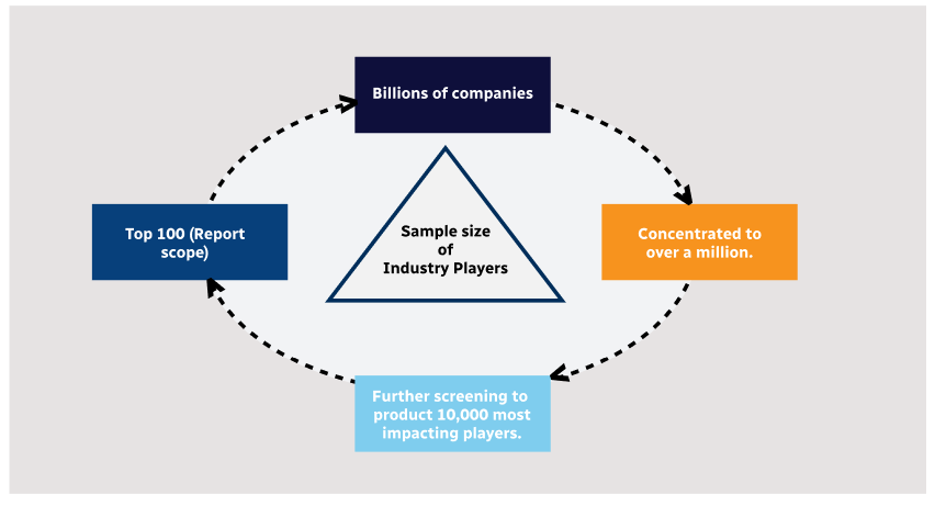
Methodology
Step 1 - Identification of Relevant Samples Size from Population Database
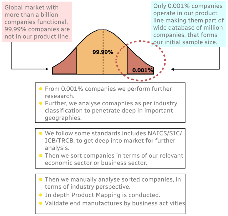
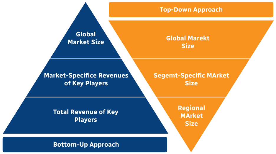
Step 2 - Approaches for Defining Global Market Size (Value, Volume* & Price*)
Note*: In applicable scenarios
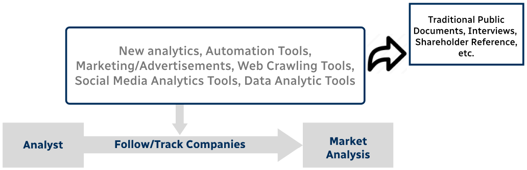
Step 3 - Data Sources
Primary Research
- Web Analytics
- Survey Reports
- Research Institute
- Latest Research Reports
- Opinion Leaders
Secondary Research
- Annual Reports
- White Paper
- Latest Press Release
- Industry Association
- Paid Database
- Investor Presentations
Step 4 - Data Triangulation
Involves using different sources of information in order to increase the validity of a study
These sources are likely to be stakeholders in a program - participants, other researchers, program staff, other community members, and so on.
Then we put all data in single framework & apply various statistical tools to find out the dynamic on the market.
During the analysis stage, feedback from the stakeholder groups would be compared to determine areas of agreement as well as areas of divergence