


Key Insights
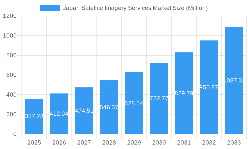
The Japan Satellite Imagery Services Market is poised for significant expansion, projected to reach an estimated 357.28 Million by 2025. This growth is fueled by a robust Compound Annual Growth Rate (CAGR) of 15.25% during the forecast period of 2025-2033. Key drivers propelling this market forward include the increasing demand for high-resolution geospatial data acquisition and mapping, essential for infrastructure development and urban planning. Furthermore, the imperative for effective natural resource management, driven by environmental concerns and sustainable practices, is a major contributor. The growing adoption of satellite imagery for surveillance and security applications by both government agencies and private enterprises, coupled with its critical role in conservation and research initiatives, further solidifies the market's upward trajectory. The need for enhanced disaster management capabilities, particularly in a seismically active region like Japan, and the strategic importance of intelligence gathering for military and defense operations are also significant growth catalysts.

Japan Satellite Imagery Services Market Market Size (In Million)

The market is segmented across various crucial applications, including Geospatial Data Acquisition and Mapping, Natural Resource Management, Surveillance and Security, Conservation and Research, Disaster Management, and Intelligence. These applications are served by a diverse range of end-users, with the Government sector leading the adoption, followed by Construction, Transportation and Logistics, Military and Defense, and Forestry and Agriculture. Emerging trends like the integration of artificial intelligence and machine learning with satellite imagery for advanced analytics and the increasing use of commercial satellite constellations for broader coverage and faster data delivery are expected to shape market dynamics. While the market benefits from strong governmental support and technological advancements, potential restraints might include high initial investment costs for some advanced applications and the need for robust data processing and interpretation infrastructure. Leading companies such as L3Harris Technologies Inc, Airbus SE, Maxar Technologies, and NTT Data Corporation are actively participating in this evolving market, driving innovation and expanding service offerings.
Japan Satellite Imagery Services Market Company Market Share
This comprehensive report provides an in-depth analysis of the Japan Satellite Imagery Services Market, a rapidly evolving sector driven by technological advancements, increasing demand for geospatial data, and government initiatives. The study covers the historical period from 2019 to 2024, the base and estimated year of 2025, and a detailed forecast period from 2025 to 2033. With an estimated market size of XX Million USD in 2025, the report delves into market concentration, innovation, key trends, dominant segments, product developments, and crucial growth drivers and challenges. It is an essential resource for industry stakeholders seeking to understand the competitive landscape, emerging opportunities, and strategic outlook for satellite imagery services in Japan.
Japan Satellite Imagery Services Market Market Concentration & Innovation
The Japan Satellite Imagery Services Market exhibits a XX% market concentration, characterized by a blend of established global players and specialized domestic providers. Innovation in this market is primarily driven by advancements in satellite sensor technology, leading to higher resolution imagery, increased spectral capabilities, and more frequent revisit times. Artificial intelligence (AI) and machine learning (ML) are also pivotal in developing sophisticated data processing and analysis tools, enhancing the value proposition for end-users. Regulatory frameworks, while supportive of space exploration and data utilization, are continuously adapting to address data privacy, security, and international cooperation. Product substitutes, such as aerial imagery and ground-based sensors, are present but often lack the broad coverage and scalability of satellite imagery. End-user trends show a growing demand for real-time data and actionable insights across diverse applications. Mergers and acquisitions (M&A) activities are moderate, with XX Million USD in M&A deal values recorded historically, indicating consolidation and strategic partnerships to expand service offerings and market reach.
Japan Satellite Imagery Services Market Industry Trends & Insights
The Japan Satellite Imagery Services Market is poised for significant growth, projected to expand at a Compound Annual Growth Rate (CAGR) of XX% from 2025 to 2033. This robust growth is fueled by an escalating demand for high-resolution geospatial data across various sectors, including natural resource management, disaster response, infrastructure development, and national security. Technological disruptions, such as the proliferation of small satellites (smallsats) and advancements in synthetic aperture radar (SAR) and optical imaging, are democratizing access to satellite data and enabling novel applications. Consumer preferences are shifting towards integrated solutions that combine data acquisition, processing, and analysis, offering end-to-end services. The competitive dynamics are intensifying, with both global players and innovative Japanese companies vying for market share. Key market penetration is observed in government and defense sectors, with increasing adoption in commercial applications. The market is experiencing a transition towards value-added services and data analytics, moving beyond mere imagery provision.
Dominant Markets & Segments in Japan Satellite Imagery Services Market
The Geospatial Data Acquisition and Mapping segment stands out as the dominant force within the Japan Satellite Imagery Services Market, driven by its foundational role in numerous downstream applications. Its dominance is underpinned by robust economic policies that support infrastructure development and urban planning, requiring precise and up-to-date mapping data. The Government end-user segment is the largest consumer, heavily relying on satellite imagery for national security, defense, disaster management, and resource monitoring. The Surveillance and Security application, closely linked to government and military end-users, also exhibits significant market penetration due to Japan's strategic geopolitical position and ongoing defense modernization efforts.
- Application: Geospatial Data Acquisition and Mapping:
- Key Drivers: Urban planning, infrastructure development, cadastral mapping, cartography, environmental monitoring.
- Dominance Analysis: This segment's prominence stems from the fundamental need for accurate spatial information across all sectors. Government mandates for national mapping projects and commercial real estate development contribute to its sustained demand.
- End-User: Government:
- Key Drivers: National security, defense modernization, disaster preparedness and response, land use management, public infrastructure oversight.
- Dominance Analysis: Government agencies are the largest purchasers of satellite imagery services, utilizing the data for critical national functions. Investments in advanced surveillance and intelligence gathering further bolster this segment's market share.
- Application: Surveillance and Security:
- Key Drivers: Border monitoring, critical infrastructure protection, anti-terrorism efforts, maritime surveillance, public safety.
- Dominance Analysis: The inherent value of satellite imagery for broad-area surveillance and real-time monitoring makes this a critical application, especially given regional security concerns.
- End-User: Military and Defense:
- Key Drivers: Intelligence, reconnaissance, target acquisition, strategic planning, situational awareness.
- Dominance Analysis: National defense spending and the continuous need for superior intelligence capabilities make the military and defense sector a prime market for high-resolution and multi-spectral satellite imagery.
- Application: Disaster Management:
- Key Drivers: Earthquake preparedness, tsunami monitoring, flood forecasting, volcanic eruption monitoring, damage assessment.
- Dominance Analysis: Japan's vulnerability to natural disasters drives significant investment in satellite-based disaster management solutions for early warning systems and rapid response.
Japan Satellite Imagery Services Market Product Developments
Product development in the Japan Satellite Imagery Services Market is characterized by a focus on enhancing image resolution, spectral capabilities, and temporal revisit rates. Innovations in optical sensors are yielding sharper imagery, while advancements in SAR technology enable all-weather, day-and-night imaging. The integration of AI and ML algorithms is transforming raw satellite data into actionable intelligence and predictive insights. Competitive advantages are being built around specialized data fusion techniques, end-to-end service platforms, and the development of tailored solutions for specific industry needs. The trend towards smaller, more agile satellites also allows for more frequent data collection, catering to the growing demand for near real-time monitoring.
Report Scope & Segmentation Analysis
This report segments the Japan Satellite Imagery Services Market by Application and End-User. The Application segments include Geospatial Data Acquisition and Mapping, Natural Resource Management, Surveillance and Security, Conservation and Research, Disaster Management, and Intelligence. The End-User segments comprise Government, Construction, Transportation and Logistics, Military and Defense, Forestry and Agriculture, and Other End-Users. Each segment is analyzed for its market size, projected growth, and competitive dynamics, providing a granular view of the market's structure and opportunities within these distinct areas.
- Geospatial Data Acquisition and Mapping: Projected to grow at a CAGR of XX% from 2025-2033, with an estimated market size of XX Million USD in 2025.
- Natural Resource Management: Anticipated to expand at a CAGR of XX%, driven by environmental regulations and sustainable practices.
- Surveillance and Security: Expected to see a CAGR of XX%, fueled by national security imperatives.
- Conservation and Research: Forecasted to grow at XX% CAGR, supporting scientific studies and ecological preservation.
- Disaster Management: A crucial segment with an anticipated CAGR of XX%, driven by Japan's seismic activity.
- Intelligence: Projected to grow at XX% CAGR, integral to national defense and strategic planning.
- Government: Dominant end-user with XX% market share in 2025, projected to grow at XX% CAGR.
- Construction: Expected to grow at XX% CAGR, supporting infrastructure projects.
- Transportation and Logistics: Anticipated to expand at XX% CAGR, aiding supply chain optimization.
- Military and Defense: A significant segment with XX% market share in 2025, growing at XX% CAGR.
- Forestry and Agriculture: Forecasted to grow at XX% CAGR, supporting precision farming and forest management.
- Other End-Users: Encompassing diverse industries, expected to grow at XX% CAGR.
Key Drivers of Japan Satellite Imagery Services Market Growth
The Japan Satellite Imagery Services Market is propelled by several key drivers. Firstly, the increasing demand for high-resolution and accurate geospatial data for urban planning, infrastructure development, and resource management is a primary catalyst. Secondly, the government's commitment to disaster preparedness and response, particularly in earthquake-prone regions, significantly boosts the adoption of satellite imagery services. Thirdly, advancements in satellite technology, including the miniaturization of satellites and improved sensor capabilities, are making these services more accessible and cost-effective. Finally, the growing emphasis on environmental monitoring and climate change research further fuels the demand for satellite-based data solutions.
Challenges in the Japan Satellite Imagery Services Market Sector
Despite its growth trajectory, the Japan Satellite Imagery Services Market faces several challenges. High initial investment costs for launching and maintaining satellite constellations can be a barrier for new entrants. Data processing and analysis complexities require specialized expertise and sophisticated infrastructure, which can be a bottleneck for some end-users. Regulatory hurdles and data privacy concerns need to be carefully navigated to ensure responsible data utilization. Furthermore, the market is subject to geopolitical influences and competition from global providers, requiring domestic companies to continuously innovate and differentiate their offerings. Supply chain disruptions in the manufacturing of satellite components can also impact service delivery timelines and costs.
Emerging Opportunities in Japan Satellite Imagery Services Market
Emerging opportunities in the Japan Satellite Imagery Services Market are diverse and promising. The increasing adoption of Internet of Things (IoT) devices and edge computing presents an opportunity for integrating satellite data with real-time sensor networks for enhanced monitoring and control. The growing demand for AI-powered analytics and predictive modeling using satellite imagery opens new avenues for value-added services. Furthermore, the development of small satellite constellations offering high revisit rates and specialized imaging capabilities (e.g., thermal imaging) is creating niche markets. The expansion of satellite imagery applications in precision agriculture, smart cities, and renewable energy management also represents significant growth potential.
Leading Players in the Japan Satellite Imagery Services Market Market
- L3Harris Technologies Inc
- Airbus SE
- Japan Aerospace Exploration Agency (JAXA)
- Maxar Technologies
- New Japan Radio Co Ltd
- NTT Data Corporation
- Remote Sensing Technology Center of Japan (RESTEC)
- Kokusai Kogyo Co Ltd
- PASCO Corporation
- Mitsubishi Electric
Key Developments in Japan Satellite Imagery Services Market Industry
- January 2023: Axelspace announced an agreement with New Space Intelligence, a Japanese satellite imagery analysis service provider. This partnership aims to expand satellite data utilization by developing new applications using satellite imagery.
- November 2022: Japan Space Imaging Corporation signed an agreement with Satellite Vu to launch a unique constellation of satellites delivering high-resolution thermal data from space. This collaboration will grant preferred access to Satellite Vu's imagery, products, and services for the company's customers and partners.
Strategic Outlook for Japan Satellite Imagery Services Market Market
The strategic outlook for the Japan Satellite Imagery Services Market is highly positive, driven by ongoing technological advancements and a deepening understanding of the value derived from geospatial data. The market's growth will be further propelled by increased investment in national infrastructure, defense modernization, and climate change mitigation efforts. The development of more accessible and affordable satellite data solutions, coupled with advanced AI-driven analytics, will unlock new applications and expand the customer base. Strategic partnerships and collaborations, both domestically and internationally, will be crucial for players to enhance their service portfolios and maintain a competitive edge in this dynamic sector. The focus will likely shift towards providing integrated, end-to-end solutions that offer actionable insights rather than just raw imagery.
Japan Satellite Imagery Services Market Segmentation
-
1. Application
- 1.1. Geospatial Data Acquisition and Mapping
- 1.2. Natural Resource Management
- 1.3. Surveillance and Security
- 1.4. Conservation and Research
- 1.5. Disaster Management
- 1.6. Intelligence
-
2. End-User
- 2.1. Government
- 2.2. Construction
- 2.3. Transportation and Logistics
- 2.4. Military and Defense
- 2.5. Forestry and Agriculture
- 2.6. Other End-Users
Japan Satellite Imagery Services Market Segmentation By Geography
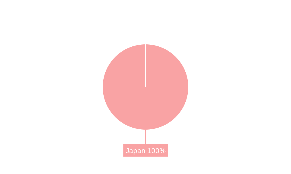
- 1. Japan
Japan Satellite Imagery Services Market Regional Market Share
Geographic Coverage of Japan Satellite Imagery Services Market
Japan Satellite Imagery Services Market REPORT HIGHLIGHTS
| Aspects | Details |
|---|---|
| Study Period | 2020-2034 |
| Base Year | 2025 |
| Estimated Year | 2026 |
| Forecast Period | 2026-2034 |
| Historical Period | 2020-2025 |
| Growth Rate | CAGR of 15.25% from 2020-2034 |
| Segmentation |
|
Table of Contents
- 1. Introduction
- 1.1. Research Scope
- 1.2. Market Segmentation
- 1.3. Research Methodology
- 1.4. Definitions and Assumptions
- 2. Executive Summary
- 2.1. Introduction
- 3. Market Dynamics
- 3.1. Introduction
- 3.2. Market Drivers
- 3.2.1. Infrastructural Development in Japan; Increasing Requirement for Mapping and Navigation System
- 3.3. Market Restrains
- 3.3.1. Regulatory and Legal Challenges
- 3.4. Market Trends
- 3.4.1. Infrastructural Development in Japan
- 4. Market Factor Analysis
- 4.1. Porters Five Forces
- 4.2. Supply/Value Chain
- 4.3. PESTEL analysis
- 4.4. Market Entropy
- 4.5. Patent/Trademark Analysis
- 5. Japan Satellite Imagery Services Market Analysis, Insights and Forecast, 2020-2032
- 5.1. Market Analysis, Insights and Forecast - by Application
- 5.1.1. Geospatial Data Acquisition and Mapping
- 5.1.2. Natural Resource Management
- 5.1.3. Surveillance and Security
- 5.1.4. Conservation and Research
- 5.1.5. Disaster Management
- 5.1.6. Intelligence
- 5.2. Market Analysis, Insights and Forecast - by End-User
- 5.2.1. Government
- 5.2.2. Construction
- 5.2.3. Transportation and Logistics
- 5.2.4. Military and Defense
- 5.2.5. Forestry and Agriculture
- 5.2.6. Other End-Users
- 5.3. Market Analysis, Insights and Forecast - by Region
- 5.3.1. Japan
- 5.1. Market Analysis, Insights and Forecast - by Application
- 6. Competitive Analysis
- 6.1. Market Share Analysis 2025
- 6.2. Company Profiles
- 6.2.1 L3Harris Technologies Inc
- 6.2.1.1. Overview
- 6.2.1.2. Products
- 6.2.1.3. SWOT Analysis
- 6.2.1.4. Recent Developments
- 6.2.1.5. Financials (Based on Availability)
- 6.2.2 Airbus SE
- 6.2.2.1. Overview
- 6.2.2.2. Products
- 6.2.2.3. SWOT Analysis
- 6.2.2.4. Recent Developments
- 6.2.2.5. Financials (Based on Availability)
- 6.2.3 Japan Aerospace Exploration Agency (JAXA)
- 6.2.3.1. Overview
- 6.2.3.2. Products
- 6.2.3.3. SWOT Analysis
- 6.2.3.4. Recent Developments
- 6.2.3.5. Financials (Based on Availability)
- 6.2.4 Maxar Technologies
- 6.2.4.1. Overview
- 6.2.4.2. Products
- 6.2.4.3. SWOT Analysis
- 6.2.4.4. Recent Developments
- 6.2.4.5. Financials (Based on Availability)
- 6.2.5 New Japan Radio Co Ltd
- 6.2.5.1. Overview
- 6.2.5.2. Products
- 6.2.5.3. SWOT Analysis
- 6.2.5.4. Recent Developments
- 6.2.5.5. Financials (Based on Availability)
- 6.2.6 NTT Data Corporation
- 6.2.6.1. Overview
- 6.2.6.2. Products
- 6.2.6.3. SWOT Analysis
- 6.2.6.4. Recent Developments
- 6.2.6.5. Financials (Based on Availability)
- 6.2.7 Remote Sensing Technology Center of Japan (RESTEC)
- 6.2.7.1. Overview
- 6.2.7.2. Products
- 6.2.7.3. SWOT Analysis
- 6.2.7.4. Recent Developments
- 6.2.7.5. Financials (Based on Availability)
- 6.2.8 Kokusai Kogyo Co Ltd
- 6.2.8.1. Overview
- 6.2.8.2. Products
- 6.2.8.3. SWOT Analysis
- 6.2.8.4. Recent Developments
- 6.2.8.5. Financials (Based on Availability)
- 6.2.9 PASCO Corporation
- 6.2.9.1. Overview
- 6.2.9.2. Products
- 6.2.9.3. SWOT Analysis
- 6.2.9.4. Recent Developments
- 6.2.9.5. Financials (Based on Availability)
- 6.2.10 Mitsubishi Electric
- 6.2.10.1. Overview
- 6.2.10.2. Products
- 6.2.10.3. SWOT Analysis
- 6.2.10.4. Recent Developments
- 6.2.10.5. Financials (Based on Availability)
- 6.2.1 L3Harris Technologies Inc
List of Figures
- Figure 1: Japan Satellite Imagery Services Market Revenue Breakdown (Million, %) by Product 2025 & 2033
- Figure 2: Japan Satellite Imagery Services Market Share (%) by Company 2025
List of Tables
- Table 1: Japan Satellite Imagery Services Market Revenue Million Forecast, by Application 2020 & 2033
- Table 2: Japan Satellite Imagery Services Market Volume K Unit Forecast, by Application 2020 & 2033
- Table 3: Japan Satellite Imagery Services Market Revenue Million Forecast, by End-User 2020 & 2033
- Table 4: Japan Satellite Imagery Services Market Volume K Unit Forecast, by End-User 2020 & 2033
- Table 5: Japan Satellite Imagery Services Market Revenue Million Forecast, by Region 2020 & 2033
- Table 6: Japan Satellite Imagery Services Market Volume K Unit Forecast, by Region 2020 & 2033
- Table 7: Japan Satellite Imagery Services Market Revenue Million Forecast, by Application 2020 & 2033
- Table 8: Japan Satellite Imagery Services Market Volume K Unit Forecast, by Application 2020 & 2033
- Table 9: Japan Satellite Imagery Services Market Revenue Million Forecast, by End-User 2020 & 2033
- Table 10: Japan Satellite Imagery Services Market Volume K Unit Forecast, by End-User 2020 & 2033
- Table 11: Japan Satellite Imagery Services Market Revenue Million Forecast, by Country 2020 & 2033
- Table 12: Japan Satellite Imagery Services Market Volume K Unit Forecast, by Country 2020 & 2033
Frequently Asked Questions
1. What is the projected Compound Annual Growth Rate (CAGR) of the Japan Satellite Imagery Services Market?
The projected CAGR is approximately 15.25%.
2. Which companies are prominent players in the Japan Satellite Imagery Services Market?
Key companies in the market include L3Harris Technologies Inc, Airbus SE, Japan Aerospace Exploration Agency (JAXA), Maxar Technologies, New Japan Radio Co Ltd, NTT Data Corporation, Remote Sensing Technology Center of Japan (RESTEC), Kokusai Kogyo Co Ltd, PASCO Corporation, Mitsubishi Electric.
3. What are the main segments of the Japan Satellite Imagery Services Market?
The market segments include Application, End-User.
4. Can you provide details about the market size?
The market size is estimated to be USD 357.28 Million as of 2022.
5. What are some drivers contributing to market growth?
Infrastructural Development in Japan; Increasing Requirement for Mapping and Navigation System.
6. What are the notable trends driving market growth?
Infrastructural Development in Japan.
7. Are there any restraints impacting market growth?
Regulatory and Legal Challenges.
8. Can you provide examples of recent developments in the market?
January 2023: Axelspace announced that the company signed an agreement with New Space Intelligence which is a Japanese satellite imagery analysis service provider company. With this partnership, both companies will work together to promote the expansion of satellite data utilization by developing new applications using satellite imagery.
9. What pricing options are available for accessing the report?
Pricing options include single-user, multi-user, and enterprise licenses priced at USD 3800, USD 4500, and USD 5800 respectively.
10. Is the market size provided in terms of value or volume?
The market size is provided in terms of value, measured in Million and volume, measured in K Unit.
11. Are there any specific market keywords associated with the report?
Yes, the market keyword associated with the report is "Japan Satellite Imagery Services Market," which aids in identifying and referencing the specific market segment covered.
12. How do I determine which pricing option suits my needs best?
The pricing options vary based on user requirements and access needs. Individual users may opt for single-user licenses, while businesses requiring broader access may choose multi-user or enterprise licenses for cost-effective access to the report.
13. Are there any additional resources or data provided in the Japan Satellite Imagery Services Market report?
While the report offers comprehensive insights, it's advisable to review the specific contents or supplementary materials provided to ascertain if additional resources or data are available.
14. How can I stay updated on further developments or reports in the Japan Satellite Imagery Services Market?
To stay informed about further developments, trends, and reports in the Japan Satellite Imagery Services Market, consider subscribing to industry newsletters, following relevant companies and organizations, or regularly checking reputable industry news sources and publications.
Methodology
Step 1 - Identification of Relevant Samples Size from Population Database


Step 2 - Approaches for Defining Global Market Size (Value, Volume* & Price*)

Note*: In applicable scenarios
Step 3 - Data Sources
Primary Research
- Web Analytics
- Survey Reports
- Research Institute
- Latest Research Reports
- Opinion Leaders
Secondary Research
- Annual Reports
- White Paper
- Latest Press Release
- Industry Association
- Paid Database
- Investor Presentations

Step 4 - Data Triangulation
Involves using different sources of information in order to increase the validity of a study
These sources are likely to be stakeholders in a program - participants, other researchers, program staff, other community members, and so on.
Then we put all data in single framework & apply various statistical tools to find out the dynamic on the market.
During the analysis stage, feedback from the stakeholder groups would be compared to determine areas of agreement as well as areas of divergence