
Key Insights
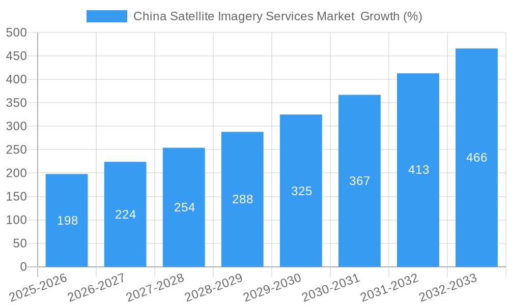
The China satellite imagery services market is experiencing robust growth, driven by increasing government investment in infrastructure development, advancements in satellite technology, and rising demand across diverse sectors. The market's Compound Annual Growth Rate (CAGR) of 13.20% from 2019 to 2024 indicates a significant upward trajectory. This expansion is fueled by several key factors. Firstly, the government's focus on modernization and urbanization initiatives necessitates detailed and up-to-date geospatial data, making satellite imagery a crucial tool for urban planning, infrastructure monitoring, and resource management. Secondly, the increasing sophistication of satellite technology, including higher resolution imagery and faster data processing capabilities, is enhancing the value proposition of satellite imagery services. Finally, the adoption of satellite imagery is spreading across various sectors, including construction, transportation, agriculture, and defense, each contributing to the market's overall growth. The government sector remains a major end-user, followed by construction, transportation, and defense. Competitive landscape analysis reveals a mix of both domestic and international players, with Chinese companies gaining significant traction in the market.
Looking forward, the forecast period of 2025-2033 promises continued expansion. Assuming a consistent CAGR of 13.20% from the 2024 market size, we can project substantial growth. While challenges such as data security concerns and the need for skilled professionals remain, the overall outlook for the China satellite imagery services market is positive. Continued technological innovation, along with supportive government policies, will likely propel the market toward even greater heights in the coming years. Specific applications like precision agriculture, environmental monitoring, and disaster response are expected to see significant growth within this market. The expansion of 5G and improved internet infrastructure will further enhance the accessibility and utilization of satellite imagery data.
China Satellite Imagery Services Market: A Comprehensive Report (2019-2033)
This comprehensive report provides an in-depth analysis of the China Satellite Imagery Services Market, offering invaluable insights for industry stakeholders, investors, and strategic decision-makers. The report covers the period from 2019 to 2033, with 2025 as the base year and a forecast period spanning 2025-2033. The market's size is projected to reach xx Million by 2033, exhibiting a CAGR of xx% during the forecast period.
China Satellite Imagery Services Market Concentration & Innovation
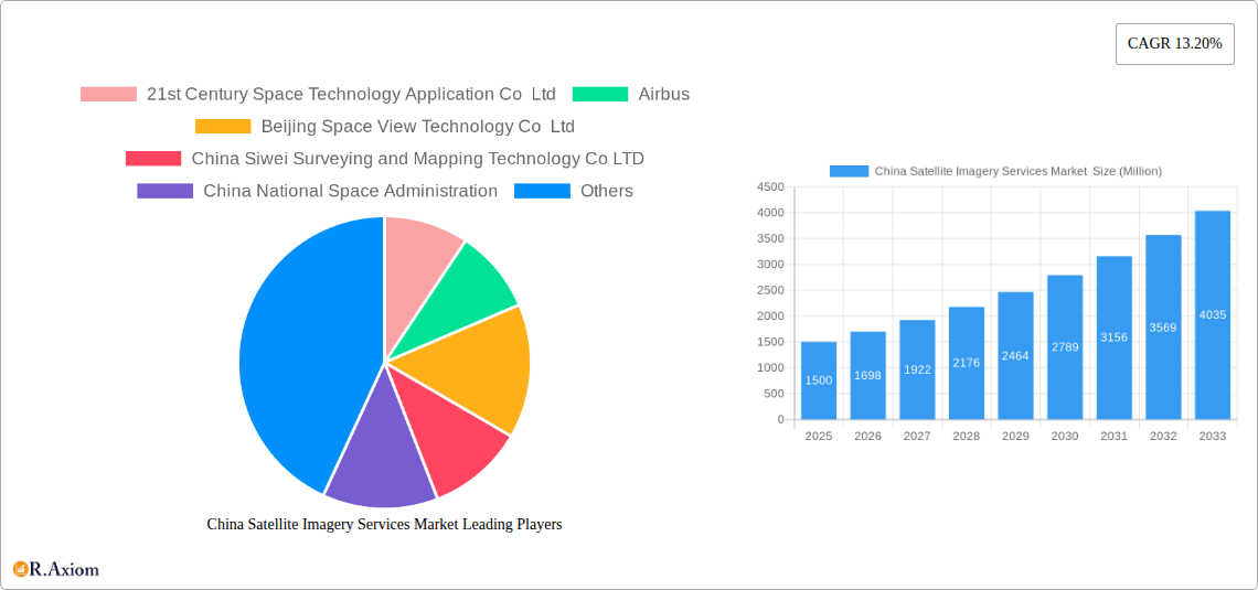
The China satellite imagery services market exhibits a moderately concentrated landscape, with a few major players and a larger number of smaller, specialized firms. Key players such as Airbus and Mapbox compete alongside domestic giants like 21st Century Space Technology Application Co Ltd and Beijing Space View Technology Co Ltd. Market share data for 2024 indicates that the top five players hold approximately xx% of the market, while the remaining share is distributed among numerous smaller companies. This dynamic is driven by ongoing innovation in satellite technology, data processing capabilities, and application development.
- Innovation Drivers: Advancements in sensor technology (e.g., hyperspectral imaging), improved data analytics (AI/ML integration), and the development of cloud-based platforms are significant drivers.
- Regulatory Framework: The Chinese government's support for space exploration and related technologies significantly impacts market growth. However, regulations surrounding data security and access present certain challenges.
- Product Substitutes: Aerial photography and LiDAR technology serve as partial substitutes, but satellite imagery offers unique advantages in terms of coverage area and revisit time.
- End-User Trends: Increasing demand for high-resolution imagery from government agencies (military and civilian) and commercial sectors is shaping market growth.
- M&A Activities: While specific deal values are not publicly available for all transactions, the market has seen several mergers and acquisitions in recent years, primarily focused on consolidating data processing capabilities and expanding geographic reach. For example, the merger between xx and xx in [year] resulted in a combined market share of xx%.
China Satellite Imagery Services Market Industry Trends & Insights
The China satellite imagery services market is experiencing robust growth, propelled by several key factors. Government initiatives promoting the development of the space industry and the increasing adoption of satellite imagery across various sectors contribute to this expansion. The market's growth is further amplified by technological advancements leading to higher resolution imagery, faster processing speeds, and the development of innovative applications. The increasing affordability of satellite data also broadens market accessibility. Specific segments, such as surveillance and security and disaster management, exhibit particularly high growth rates. The market penetration rate for satellite imagery in various sectors is steadily increasing, reflecting growing awareness of its value and diverse applications. The overall market is expected to maintain a healthy CAGR of xx% during the forecast period (2025-2033). Competitive dynamics are characterized by both domestic and international players vying for market share, often through strategic partnerships, technological innovation, and expansion into new applications. Consumer preferences are shifting towards cloud-based solutions and value-added services that integrate satellite data with other data sources for more comprehensive analysis.
Dominant Markets & Segments in China Satellite Imagery Services Market
The government sector dominates the end-user segment, driven by significant investments in national security, infrastructure development, and environmental monitoring. The Geospatial Data Acquisition and Mapping application segment is the largest, followed by Surveillance and Security, which is rapidly expanding due to the increasing emphasis on national security.
- Key Drivers in Government Segment: National security priorities, large-scale infrastructure projects, and environmental monitoring programs.
- Key Drivers in Geospatial Data Acquisition and Mapping: Urban planning, infrastructure development, and precision agriculture.
- Key Drivers in Surveillance and Security: Border security, crime prevention, and disaster response.
The dominance of these segments is further reinforced by supportive government policies, significant funding allocations, and the strategic importance of geospatial information. Other significant end-user segments include construction, transportation and logistics, and military and defense. Regional dominance is largely concentrated in urban and economically developed areas of China, where access to technology and infrastructure is better.
China Satellite Imagery Services Market Product Developments
Recent product innovations include the development of higher-resolution sensors, advanced analytics platforms leveraging AI and machine learning, and cloud-based services for easier access and distribution of satellite imagery. These developments have enhanced the speed, accuracy, and usability of satellite imagery data, expanding applications across various industries and attracting a wider range of users. The competitive advantage lies in offering comprehensive solutions that integrate data acquisition, processing, and analysis tools, along with tailored applications for specific industry needs. This trend is reinforced by the increasing demand for value-added services, such as ready-to-use analytical reports and customized data visualizations.
Report Scope & Segmentation Analysis
This report segments the China Satellite Imagery Services Market by Application (Geospatial Data Acquisition and Mapping, Natural Resource Management, Surveillance and Security, Conservation and Research, Disaster Management, Intelligence) and by End-User (Government, Construction, Transportation and Logistics, Military and Defense, Forestry and Agriculture, Other End-Users). Each segment is analyzed in detail, offering growth projections, market size estimates, and competitive dynamics. For instance, the Geospatial Data Acquisition and Mapping segment is expected to maintain a strong growth trajectory, driven by increasing urbanization and infrastructure development, while the Surveillance and Security segment is projected to experience rapid expansion due to increasing national security concerns.
Key Drivers of China Satellite Imagery Services Market Growth
Several factors propel the growth of the China satellite imagery services market. Technological advancements, such as higher-resolution sensors and improved processing capabilities, are key drivers. Government support for the space industry and substantial investments in infrastructure projects create significant demand. Furthermore, increasing awareness of the value of satellite imagery across various sectors and supportive regulatory frameworks foster market expansion. The increasing availability of affordable satellite data further broadens market accessibility and fuels growth.
Challenges in the China Satellite Imagery Services Market Sector
The market faces several challenges, including data security and privacy concerns, which necessitate robust regulatory frameworks and security measures. Supply chain disruptions can affect the availability of components and expertise, impacting production and service delivery. Intense competition from both domestic and international players necessitates continuous innovation and differentiation to maintain a competitive edge. Moreover, the high cost of satellite imagery and data processing can restrict market access for smaller players and specific applications.
Emerging Opportunities in China Satellite Imagery Services Market
Emerging opportunities include the growing adoption of AI and machine learning for advanced data analytics, allowing for more efficient extraction of valuable information. The development of new applications in sectors such as precision agriculture and environmental monitoring offers significant growth potential. Furthermore, the expansion into new markets with increasing demand for geospatial data, along with the integration of satellite imagery with other data sources, opens up new possibilities. The development of miniaturized satellites and constellations is reducing data acquisition costs and improving the frequency of data updates.
Leading Players in the China Satellite Imagery Services Market Market
- 21st Century Space Technology Application Co Ltd
- Airbus (Airbus)
- Beijing Space View Technology Co Ltd
- China Siwei Surveying and Mapping Technology Co LTD
- China National Space Administration
- Mapbox (Mapbox)
- Beijing Zero Map Information Technology Co Ltd
- CHANG GUANG SATELLITE TECHNOLOGY CO LTD
- National Satellite Meteorological Center
- HEAD Aerospace Group
Key Developments in China Satellite Imagery Services Market Industry
- June 2023: China shared 400 scenes (1.5 TB) of satellite imagery data with BRICS nations, boosting market growth and creating opportunities for domestic vendors.
- January 2023: Spacety provided synthetic aperture radar satellite images to a Russian firm, highlighting the role of Chinese companies in military applications and fueling market expansion.
Strategic Outlook for China Satellite Imagery Services Market Market
The China satellite imagery services market is poised for continued growth, driven by sustained government investment, technological advancements, and increasing demand across diverse sectors. The integration of AI/ML, the expansion into new applications, and the development of affordable data solutions will shape future market dynamics. Strategic partnerships, innovation in data processing, and expansion into new geographical markets will be crucial for success in this rapidly evolving landscape. The market's long-term potential is significant, promising significant returns for investors and stakeholders.
China Satellite Imagery Services Market Segmentation
-
1. Application
- 1.1. Geospatial Data Acquisition and Mapping
- 1.2. Natural Resource Management
- 1.3. Surveillance and Security
- 1.4. Conservation and Research
- 1.5. Disaster Management
- 1.6. Intelligence
-
2. End-User
- 2.1. Government
- 2.2. Construction
- 2.3. Transportation and Logistics
- 2.4. Military and Defense
- 2.5. Forestry and Agriculture
- 2.6. Other End-Users
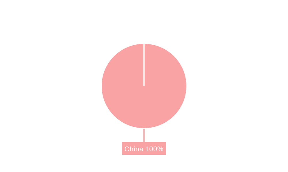
China Satellite Imagery Services Market Segmentation By Geography
- 1. China
China Satellite Imagery Services Market REPORT HIGHLIGHTS
| Aspects | Details |
|---|---|
| Study Period | 2019-2033 |
| Base Year | 2024 |
| Estimated Year | 2025 |
| Forecast Period | 2025-2033 |
| Historical Period | 2019-2024 |
| Growth Rate | CAGR of 13.20% from 2019-2033 |
| Segmentation |
|
Table of Contents
- 1. Introduction
- 1.1. Research Scope
- 1.2. Market Segmentation
- 1.3. Research Methodology
- 1.4. Definitions and Assumptions
- 2. Executive Summary
- 2.1. Introduction
- 3. Market Dynamics
- 3.1. Introduction
- 3.2. Market Drivers
- 3.2.1. The country's Investments in Space Technology and Defence; Adoption of Big Data and Imagery Analytics
- 3.3. Market Restrains
- 3.3.1. High Cost of Satellite Imaging Data Acquisition and Processing; High-resolution Images Offered by Other Imaging Technologies
- 3.4. Market Trends
- 3.4.1. The country's Investments in Space Technology and Defense Drives Market Growth.
- 4. Market Factor Analysis
- 4.1. Porters Five Forces
- 4.2. Supply/Value Chain
- 4.3. PESTEL analysis
- 4.4. Market Entropy
- 4.5. Patent/Trademark Analysis
- 5. China Satellite Imagery Services Market Analysis, Insights and Forecast, 2019-2031
- 5.1. Market Analysis, Insights and Forecast - by Application
- 5.1.1. Geospatial Data Acquisition and Mapping
- 5.1.2. Natural Resource Management
- 5.1.3. Surveillance and Security
- 5.1.4. Conservation and Research
- 5.1.5. Disaster Management
- 5.1.6. Intelligence
- 5.2. Market Analysis, Insights and Forecast - by End-User
- 5.2.1. Government
- 5.2.2. Construction
- 5.2.3. Transportation and Logistics
- 5.2.4. Military and Defense
- 5.2.5. Forestry and Agriculture
- 5.2.6. Other End-Users
- 5.3. Market Analysis, Insights and Forecast - by Region
- 5.3.1. China
- 5.1. Market Analysis, Insights and Forecast - by Application
- 6. Competitive Analysis
- 6.1. Market Share Analysis 2024
- 6.2. Company Profiles
- 6.2.1 21st Century Space Technology Application Co Ltd
- 6.2.1.1. Overview
- 6.2.1.2. Products
- 6.2.1.3. SWOT Analysis
- 6.2.1.4. Recent Developments
- 6.2.1.5. Financials (Based on Availability)
- 6.2.2 Airbus
- 6.2.2.1. Overview
- 6.2.2.2. Products
- 6.2.2.3. SWOT Analysis
- 6.2.2.4. Recent Developments
- 6.2.2.5. Financials (Based on Availability)
- 6.2.3 Beijing Space View Technology Co Ltd
- 6.2.3.1. Overview
- 6.2.3.2. Products
- 6.2.3.3. SWOT Analysis
- 6.2.3.4. Recent Developments
- 6.2.3.5. Financials (Based on Availability)
- 6.2.4 China Siwei Surveying and Mapping Technology Co LTD
- 6.2.4.1. Overview
- 6.2.4.2. Products
- 6.2.4.3. SWOT Analysis
- 6.2.4.4. Recent Developments
- 6.2.4.5. Financials (Based on Availability)
- 6.2.5 China National Space Administration
- 6.2.5.1. Overview
- 6.2.5.2. Products
- 6.2.5.3. SWOT Analysis
- 6.2.5.4. Recent Developments
- 6.2.5.5. Financials (Based on Availability)
- 6.2.6 Mapbox
- 6.2.6.1. Overview
- 6.2.6.2. Products
- 6.2.6.3. SWOT Analysis
- 6.2.6.4. Recent Developments
- 6.2.6.5. Financials (Based on Availability)
- 6.2.7 Beijing Zero Map Information Technology Co Ltd
- 6.2.7.1. Overview
- 6.2.7.2. Products
- 6.2.7.3. SWOT Analysis
- 6.2.7.4. Recent Developments
- 6.2.7.5. Financials (Based on Availability)
- 6.2.8 CHANG GUANG SATELLITE TECHNOLOGY CO LTD
- 6.2.8.1. Overview
- 6.2.8.2. Products
- 6.2.8.3. SWOT Analysis
- 6.2.8.4. Recent Developments
- 6.2.8.5. Financials (Based on Availability)
- 6.2.9 National Satellite Meteorological Center
- 6.2.9.1. Overview
- 6.2.9.2. Products
- 6.2.9.3. SWOT Analysis
- 6.2.9.4. Recent Developments
- 6.2.9.5. Financials (Based on Availability)
- 6.2.10 HEAD Aerospace Group
- 6.2.10.1. Overview
- 6.2.10.2. Products
- 6.2.10.3. SWOT Analysis
- 6.2.10.4. Recent Developments
- 6.2.10.5. Financials (Based on Availability)
- 6.2.1 21st Century Space Technology Application Co Ltd
List of Figures
- Figure 1: China Satellite Imagery Services Market Revenue Breakdown (Million, %) by Product 2024 & 2032
- Figure 2: China Satellite Imagery Services Market Share (%) by Company 2024
List of Tables
- Table 1: China Satellite Imagery Services Market Revenue Million Forecast, by Region 2019 & 2032
- Table 2: China Satellite Imagery Services Market Revenue Million Forecast, by Application 2019 & 2032
- Table 3: China Satellite Imagery Services Market Revenue Million Forecast, by End-User 2019 & 2032
- Table 4: China Satellite Imagery Services Market Revenue Million Forecast, by Region 2019 & 2032
- Table 5: China Satellite Imagery Services Market Revenue Million Forecast, by Country 2019 & 2032
- Table 6: China Satellite Imagery Services Market Revenue Million Forecast, by Application 2019 & 2032
- Table 7: China Satellite Imagery Services Market Revenue Million Forecast, by End-User 2019 & 2032
- Table 8: China Satellite Imagery Services Market Revenue Million Forecast, by Country 2019 & 2032
Frequently Asked Questions
1. What is the projected Compound Annual Growth Rate (CAGR) of the China Satellite Imagery Services Market ?
The projected CAGR is approximately 13.20%.
2. Which companies are prominent players in the China Satellite Imagery Services Market ?
Key companies in the market include 21st Century Space Technology Application Co Ltd, Airbus, Beijing Space View Technology Co Ltd, China Siwei Surveying and Mapping Technology Co LTD, China National Space Administration, Mapbox, Beijing Zero Map Information Technology Co Ltd, CHANG GUANG SATELLITE TECHNOLOGY CO LTD, National Satellite Meteorological Center, HEAD Aerospace Group.
3. What are the main segments of the China Satellite Imagery Services Market ?
The market segments include Application, End-User.
4. Can you provide details about the market size?
The market size is estimated to be USD XX Million as of 2022.
5. What are some drivers contributing to market growth?
The country's Investments in Space Technology and Defence; Adoption of Big Data and Imagery Analytics.
6. What are the notable trends driving market growth?
The country's Investments in Space Technology and Defense Drives Market Growth..
7. Are there any restraints impacting market growth?
High Cost of Satellite Imaging Data Acquisition and Processing; High-resolution Images Offered by Other Imaging Technologies.
8. Can you provide examples of recent developments in the market?
June 2023: The country awarded a contract to share satellite Imagery data with BRICS countries after the signing of an agreement on Cooperation on the BRICS Remote Sensing Satellite Constellation and shared 400 scenes of satellite imagery data with the BRICS countries, with the total volume amounting to 1.5 TB, which supports the growth of satellite imagery services market in China by creating a business opportunity for the Chinese vendors.
9. What pricing options are available for accessing the report?
Pricing options include single-user, multi-user, and enterprise licenses priced at USD 3800, USD 4500, and USD 5800 respectively.
10. Is the market size provided in terms of value or volume?
The market size is provided in terms of value, measured in Million.
11. Are there any specific market keywords associated with the report?
Yes, the market keyword associated with the report is "China Satellite Imagery Services Market ," which aids in identifying and referencing the specific market segment covered.
12. How do I determine which pricing option suits my needs best?
The pricing options vary based on user requirements and access needs. Individual users may opt for single-user licenses, while businesses requiring broader access may choose multi-user or enterprise licenses for cost-effective access to the report.
13. Are there any additional resources or data provided in the China Satellite Imagery Services Market report?
While the report offers comprehensive insights, it's advisable to review the specific contents or supplementary materials provided to ascertain if additional resources or data are available.
14. How can I stay updated on further developments or reports in the China Satellite Imagery Services Market ?
To stay informed about further developments, trends, and reports in the China Satellite Imagery Services Market , consider subscribing to industry newsletters, following relevant companies and organizations, or regularly checking reputable industry news sources and publications.
Methodology
Step 1 - Identification of Relevant Samples Size from Population Database


Step 2 - Approaches for Defining Global Market Size (Value, Volume* & Price*)

Note*: In applicable scenarios
Step 3 - Data Sources
Primary Research
- Web Analytics
- Survey Reports
- Research Institute
- Latest Research Reports
- Opinion Leaders
Secondary Research
- Annual Reports
- White Paper
- Latest Press Release
- Industry Association
- Paid Database
- Investor Presentations

Step 4 - Data Triangulation
Involves using different sources of information in order to increase the validity of a study
These sources are likely to be stakeholders in a program - participants, other researchers, program staff, other community members, and so on.
Then we put all data in single framework & apply various statistical tools to find out the dynamic on the market.
During the analysis stage, feedback from the stakeholder groups would be compared to determine areas of agreement as well as areas of divergence


