
Key Insights
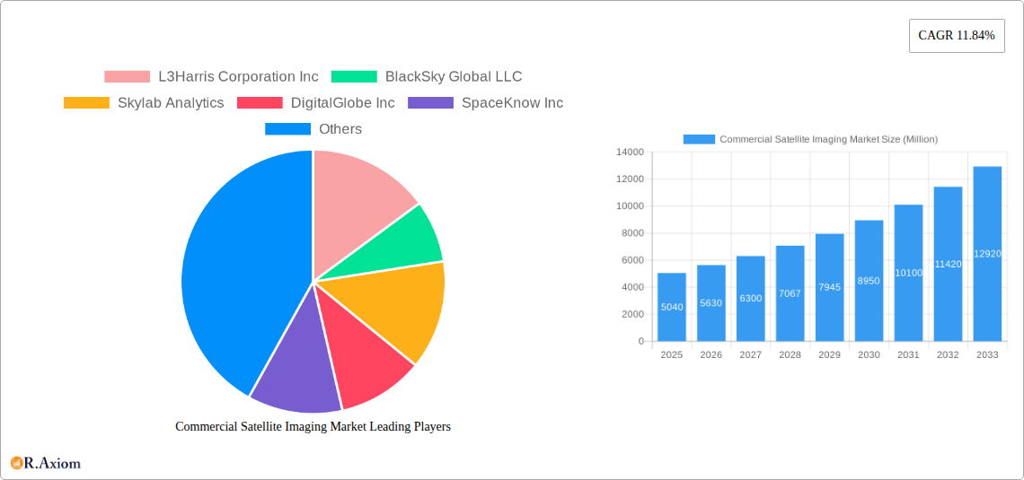
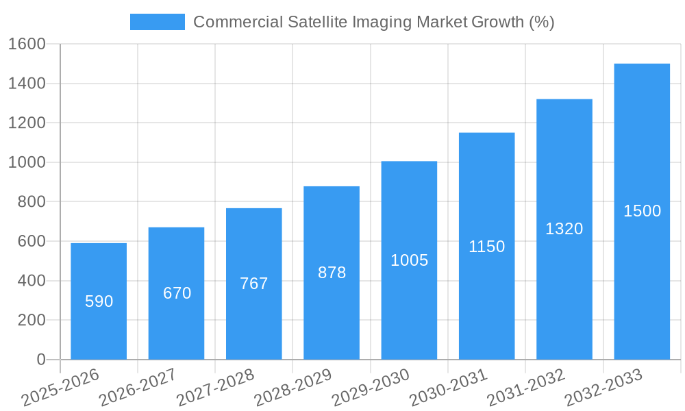
The commercial satellite imaging market is experiencing robust growth, projected to reach \$5.04 billion in 2025 and maintain a Compound Annual Growth Rate (CAGR) of 11.84% from 2025 to 2033. This expansion is driven by several key factors. Increasing demand for high-resolution imagery across diverse sectors, including geospatial data acquisition and mapping, natural resource management, and surveillance & security, is a significant catalyst. Advances in sensor technology, leading to improved image quality and data processing capabilities, further fuel market growth. Furthermore, the rising adoption of cloud-based solutions for data storage and analysis simplifies access to and utilization of satellite imagery, fostering wider adoption across industries. Governments are significant consumers, utilizing satellite imagery for infrastructure planning, disaster response, and national security. The private sector, especially in construction, transportation & logistics, and energy, leverages this technology for efficient project planning, asset monitoring, and risk mitigation.
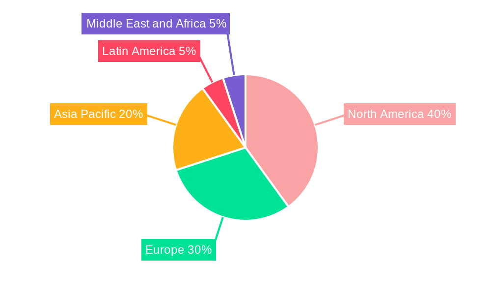
The market is segmented by application (geospatial data acquisition & mapping, natural resource management, surveillance & security, conservation & research, construction & development, disaster management, defense & intelligence) and end-user vertical (government, construction, transportation & logistics, military & defense, energy, forestry & agriculture, other). While North America currently holds a substantial market share, the Asia-Pacific region is poised for significant growth due to increasing infrastructure development and investment in advanced technologies. Competitive dynamics are shaped by a mix of established players like L3Harris, Planet Labs, and DigitalGlobe, alongside emerging companies offering innovative solutions and data analytics. While data security and privacy concerns, along with regulatory hurdles in some regions, present challenges, the overall market outlook remains strongly positive, fueled by technological advancements and the increasing reliance on geospatial intelligence across various sectors.
Commercial Satellite Imaging Market: A Comprehensive Report (2019-2033)
This in-depth report provides a comprehensive analysis of the Commercial Satellite Imaging market, offering actionable insights for industry stakeholders. The study covers the period 2019-2033, with 2025 as the base and estimated year, and a forecast period of 2025-2033. The report is meticulously structured to deliver a clear understanding of market dynamics, growth drivers, challenges, and future opportunities. The market is segmented by application and end-user vertical, offering granular insights into various market segments. The report values are expressed in Millions.
Commercial Satellite Imaging Market Concentration & Innovation
The commercial satellite imaging market exhibits a moderately concentrated landscape, with a few major players holding significant market share. However, the market is also characterized by a high degree of innovation, driven by advancements in sensor technology, data analytics, and satellite constellation development. The market share of the top 5 players is estimated to be xx%, reflecting both consolidation and the emergence of new entrants. Regulatory frameworks, particularly regarding data privacy and national security, significantly influence market operations. Product substitutes, such as aerial photography and LiDAR, exist, but satellite imagery's unique advantages in coverage and frequency often make it the preferred solution. End-user trends increasingly favor higher resolution imagery, advanced analytics, and value-added services. M&A activity has been significant in recent years, with deal values exceeding xx Million in the last five years. Several large corporations have invested heavily in this field, and smaller companies are regularly acquired for their specialized technology or geographical reach.
- Market Leaders: L3Harris Corporation Inc, Planet Labs Inc, and DigitalGlobe Inc hold substantial market share.
- Innovation Drivers: Advancements in sensor technology (e.g., hyperspectral imaging), AI-powered analytics, and miniaturization of satellites.
- M&A Activity: Significant consolidation is occurring, with larger players acquiring smaller companies to expand their capabilities and geographic reach. The average deal size is estimated to be xx Million.
- Regulatory Landscape: Stringent regulations concerning data privacy and national security are impacting market access and operations.
Commercial Satellite Imaging Market Industry Trends & Insights
The commercial satellite imaging market is experiencing robust growth, driven by increasing demand across diverse sectors. The Compound Annual Growth Rate (CAGR) is projected to be xx% during the forecast period (2025-2033). This growth is fueled by several key factors: the rising adoption of geospatial data in various applications, advancements in satellite technology resulting in higher resolution and more frequent data acquisition, increasing government investment in satellite imagery for national security and infrastructure development, and the growing affordability of satellite data. Technological disruptions, particularly in the realm of artificial intelligence and machine learning, are enhancing the analytical capabilities of satellite imagery, leading to broader applications. Consumer preferences are shifting towards higher-resolution images, faster processing speeds, and more readily accessible data. The competitive landscape is dynamic, with both established players and new entrants vying for market share through innovation, strategic partnerships, and acquisitions. Market penetration is increasing steadily across various sectors, with the government and defense sectors leading the way.
Dominant Markets & Segments in Commercial Satellite Imaging Market
The North American region dominates the commercial satellite imaging market, driven by robust government spending, advanced technology capabilities, and a strong private sector presence. Within the application segments, geospatial data acquisition and mapping holds the largest market share, followed by surveillance and security. In terms of end-user verticals, the government sector is the key driver, accounting for a significant portion of market revenue.
Key Drivers by Segment:
- Geospatial Data Acquisition and Mapping: Growing urbanization, infrastructure development, and precision agriculture initiatives.
- Natural Resource Management: Monitoring deforestation, identifying mineral deposits, and optimizing agricultural practices.
- Surveillance and Security: Increasing concerns over national security and border control.
- Government: Significant government spending on national security and infrastructure projects.
- Construction: Need for precise land surveying, site monitoring, and progress tracking.
- Transportation and Logistics: Optimizing route planning, managing infrastructure assets, and tracking shipments.
Dominance Analysis:
The dominance of North America is attributed to strong government support, a robust private sector, and advanced technological capabilities. The geospatial data acquisition and mapping segment’s dominance reflects the fundamental role of satellite imagery in various applications. The government sector's lead is due to its substantial investment in national security and infrastructure development.
Commercial Satellite Imaging Market Product Developments
Recent product innovations focus on higher-resolution imagery, improved spectral capabilities (hyperspectral and multispectral), and advanced data analytics powered by AI and machine learning. These advancements enable more accurate and detailed analysis, opening up new applications in various fields. The competitive advantage lies in the combination of high-quality data, sophisticated processing capabilities, and timely delivery of actionable insights. The market is seeing a shift towards cloud-based platforms and SaaS models to improve accessibility and affordability.
Report Scope & Segmentation Analysis
By Application:
- Geospatial Data Acquisition and Mapping: This segment is expected to witness substantial growth, driven by increasing urbanization and infrastructure development. Market size is projected at xx Million by 2033.
- Natural Resource Management: The demand for efficient resource management is driving growth in this segment. Market size is projected at xx Million by 2033.
- Surveillance and Security: Growing security concerns are fueling the demand for high-resolution imagery in this sector. Market size is projected at xx Million by 2033.
- Conservation and Research: The segment is expected to grow steadily as environmental monitoring needs increase. Market size is projected at xx Million by 2033.
- Construction and Development: This sector utilizes satellite imagery for planning, monitoring, and risk assessment. Market size is projected at xx Million by 2033.
- Disaster Management: Satellite imagery plays a crucial role in disaster response and recovery efforts. Market size is projected at xx Million by 2033.
- Defense and Intelligence: This segment benefits from high-resolution and timely data for strategic decision-making. Market size is projected at xx Million by 2033.
By End-user Vertical: The report segments the market based on end-users, providing detailed analysis of each sector's growth trajectory. Similar projections for market size by 2033 are provided for each sector as above.
Key Drivers of Commercial Satellite Imaging Market Growth
Several factors fuel the market's growth: increasing demand for high-resolution imagery across multiple sectors, advancements in satellite technology resulting in better image quality and data acquisition, and government investment in geospatial intelligence. The rising adoption of cloud-based platforms and AI-powered analytics is also contributing significantly to market expansion. Furthermore, the decreasing cost of satellite data makes it more accessible to a wider range of users.
Challenges in the Commercial Satellite Imaging Market Sector
Challenges include regulatory hurdles related to data privacy and national security, supply chain disruptions impacting satellite manufacturing and launch schedules, and intense competition among market players. These factors can impact market growth and profitability. Furthermore, the reliance on space infrastructure creates vulnerability to technical failures and geopolitical events. These challenges translate into higher costs and potential delays in project execution.
Emerging Opportunities in Commercial Satellite Imaging Market
Emerging trends include the increasing use of AI/ML for image analysis, the growth of small satellite constellations for enhanced coverage and frequency, and the development of new applications in areas such as precision agriculture and environmental monitoring. These trends create significant opportunities for market expansion and innovation. The integration of satellite imagery with other data sources, such as IoT sensors, also presents considerable opportunities.
Leading Players in the Commercial Satellite Imaging Market Market
- L3Harris Corporation Inc
- BlackSky Global LLC
- Skylab Analytics
- DigitalGlobe Inc (Acquired by Maxar)
- SpaceKnow Inc
- ImageSat International NV
- Galileo Group Inc
- European Space Imaging (EUSI) GmbH
- Planet Labs Inc
- UrtheCast Corp
Key Developments in Commercial Satellite Imaging Market Industry
- February 2024: The National Geospatial-Intelligence Agency (NGA) launched the “Luno” program, a significant procurement initiative to leverage commercial satellite imagery and analytics for enhanced global monitoring capabilities. This highlights the growing reliance on commercial sources for high-quality geospatial intelligence.
Strategic Outlook for Commercial Satellite Imaging Market Market
The commercial satellite imaging market is poised for continued growth, driven by technological advancements, increased demand across diverse sectors, and supportive government policies. The strategic focus will be on developing innovative solutions, leveraging AI and machine learning capabilities, and expanding into new applications. The market's future potential is vast, with opportunities for market expansion into emerging economies and new technological breakthroughs to drive further growth.
Commercial Satellite Imaging Market Segmentation
-
1. Application
- 1.1. Geospatial Data Acquisition and Mapping
- 1.2. Natural Resource Management
- 1.3. Surveillance and Security
- 1.4. Conservation and Research
- 1.5. Construction and Development
- 1.6. Disaster Management
- 1.7. Defense and Intelligence
-
2. End-user Vertical
- 2.1. Government
- 2.2. Construction
- 2.3. Transportation and Logistics
- 2.4. Military and Defense
- 2.5. Energy
- 2.6. Forestry and Agriculture
- 2.7. Other End-user Verticals
Commercial Satellite Imaging Market Segmentation By Geography
- 1. North America
- 2. Europe
- 3. Asia Pacific
- 4. Latin America
- 5. Middle East and Africa
Commercial Satellite Imaging Market REPORT HIGHLIGHTS
| Aspects | Details |
|---|---|
| Study Period | 2019-2033 |
| Base Year | 2024 |
| Estimated Year | 2025 |
| Forecast Period | 2025-2033 |
| Historical Period | 2019-2024 |
| Growth Rate | CAGR of 11.84% from 2019-2033 |
| Segmentation |
|
Table of Contents
- 1. Introduction
- 1.1. Research Scope
- 1.2. Market Segmentation
- 1.3. Research Methodology
- 1.4. Definitions and Assumptions
- 2. Executive Summary
- 2.1. Introduction
- 3. Market Dynamics
- 3.1. Introduction
- 3.2. Market Drivers
- 3.2.1. Increasing Requirement for Efficient Monitoring of Vast Land Areas; Rising Smart City Initiatives; Big Data and Imagery Analytics
- 3.3. Market Restrains
- 3.3.1. High-resolution Images Offered by Other Imaging Technologies
- 3.4. Market Trends
- 3.4.1. Military and Defense is Expected to Hold Significant Market Share
- 4. Market Factor Analysis
- 4.1. Porters Five Forces
- 4.2. Supply/Value Chain
- 4.3. PESTEL analysis
- 4.4. Market Entropy
- 4.5. Patent/Trademark Analysis
- 5. Global Commercial Satellite Imaging Market Analysis, Insights and Forecast, 2019-2031
- 5.1. Market Analysis, Insights and Forecast - by Application
- 5.1.1. Geospatial Data Acquisition and Mapping
- 5.1.2. Natural Resource Management
- 5.1.3. Surveillance and Security
- 5.1.4. Conservation and Research
- 5.1.5. Construction and Development
- 5.1.6. Disaster Management
- 5.1.7. Defense and Intelligence
- 5.2. Market Analysis, Insights and Forecast - by End-user Vertical
- 5.2.1. Government
- 5.2.2. Construction
- 5.2.3. Transportation and Logistics
- 5.2.4. Military and Defense
- 5.2.5. Energy
- 5.2.6. Forestry and Agriculture
- 5.2.7. Other End-user Verticals
- 5.3. Market Analysis, Insights and Forecast - by Region
- 5.3.1. North America
- 5.3.2. Europe
- 5.3.3. Asia Pacific
- 5.3.4. Latin America
- 5.3.5. Middle East and Africa
- 5.1. Market Analysis, Insights and Forecast - by Application
- 6. North America Commercial Satellite Imaging Market Analysis, Insights and Forecast, 2019-2031
- 6.1. Market Analysis, Insights and Forecast - by Application
- 6.1.1. Geospatial Data Acquisition and Mapping
- 6.1.2. Natural Resource Management
- 6.1.3. Surveillance and Security
- 6.1.4. Conservation and Research
- 6.1.5. Construction and Development
- 6.1.6. Disaster Management
- 6.1.7. Defense and Intelligence
- 6.2. Market Analysis, Insights and Forecast - by End-user Vertical
- 6.2.1. Government
- 6.2.2. Construction
- 6.2.3. Transportation and Logistics
- 6.2.4. Military and Defense
- 6.2.5. Energy
- 6.2.6. Forestry and Agriculture
- 6.2.7. Other End-user Verticals
- 6.1. Market Analysis, Insights and Forecast - by Application
- 7. Europe Commercial Satellite Imaging Market Analysis, Insights and Forecast, 2019-2031
- 7.1. Market Analysis, Insights and Forecast - by Application
- 7.1.1. Geospatial Data Acquisition and Mapping
- 7.1.2. Natural Resource Management
- 7.1.3. Surveillance and Security
- 7.1.4. Conservation and Research
- 7.1.5. Construction and Development
- 7.1.6. Disaster Management
- 7.1.7. Defense and Intelligence
- 7.2. Market Analysis, Insights and Forecast - by End-user Vertical
- 7.2.1. Government
- 7.2.2. Construction
- 7.2.3. Transportation and Logistics
- 7.2.4. Military and Defense
- 7.2.5. Energy
- 7.2.6. Forestry and Agriculture
- 7.2.7. Other End-user Verticals
- 7.1. Market Analysis, Insights and Forecast - by Application
- 8. Asia Pacific Commercial Satellite Imaging Market Analysis, Insights and Forecast, 2019-2031
- 8.1. Market Analysis, Insights and Forecast - by Application
- 8.1.1. Geospatial Data Acquisition and Mapping
- 8.1.2. Natural Resource Management
- 8.1.3. Surveillance and Security
- 8.1.4. Conservation and Research
- 8.1.5. Construction and Development
- 8.1.6. Disaster Management
- 8.1.7. Defense and Intelligence
- 8.2. Market Analysis, Insights and Forecast - by End-user Vertical
- 8.2.1. Government
- 8.2.2. Construction
- 8.2.3. Transportation and Logistics
- 8.2.4. Military and Defense
- 8.2.5. Energy
- 8.2.6. Forestry and Agriculture
- 8.2.7. Other End-user Verticals
- 8.1. Market Analysis, Insights and Forecast - by Application
- 9. Latin America Commercial Satellite Imaging Market Analysis, Insights and Forecast, 2019-2031
- 9.1. Market Analysis, Insights and Forecast - by Application
- 9.1.1. Geospatial Data Acquisition and Mapping
- 9.1.2. Natural Resource Management
- 9.1.3. Surveillance and Security
- 9.1.4. Conservation and Research
- 9.1.5. Construction and Development
- 9.1.6. Disaster Management
- 9.1.7. Defense and Intelligence
- 9.2. Market Analysis, Insights and Forecast - by End-user Vertical
- 9.2.1. Government
- 9.2.2. Construction
- 9.2.3. Transportation and Logistics
- 9.2.4. Military and Defense
- 9.2.5. Energy
- 9.2.6. Forestry and Agriculture
- 9.2.7. Other End-user Verticals
- 9.1. Market Analysis, Insights and Forecast - by Application
- 10. Middle East and Africa Commercial Satellite Imaging Market Analysis, Insights and Forecast, 2019-2031
- 10.1. Market Analysis, Insights and Forecast - by Application
- 10.1.1. Geospatial Data Acquisition and Mapping
- 10.1.2. Natural Resource Management
- 10.1.3. Surveillance and Security
- 10.1.4. Conservation and Research
- 10.1.5. Construction and Development
- 10.1.6. Disaster Management
- 10.1.7. Defense and Intelligence
- 10.2. Market Analysis, Insights and Forecast - by End-user Vertical
- 10.2.1. Government
- 10.2.2. Construction
- 10.2.3. Transportation and Logistics
- 10.2.4. Military and Defense
- 10.2.5. Energy
- 10.2.6. Forestry and Agriculture
- 10.2.7. Other End-user Verticals
- 10.1. Market Analysis, Insights and Forecast - by Application
- 11. North America Commercial Satellite Imaging Market Analysis, Insights and Forecast, 2019-2031
- 11.1. Market Analysis, Insights and Forecast - By Country/Sub-region
- 11.1.1.
- 12. Europe Commercial Satellite Imaging Market Analysis, Insights and Forecast, 2019-2031
- 12.1. Market Analysis, Insights and Forecast - By Country/Sub-region
- 12.1.1.
- 13. Asia Pacific Commercial Satellite Imaging Market Analysis, Insights and Forecast, 2019-2031
- 13.1. Market Analysis, Insights and Forecast - By Country/Sub-region
- 13.1.1.
- 14. Latin America Commercial Satellite Imaging Market Analysis, Insights and Forecast, 2019-2031
- 14.1. Market Analysis, Insights and Forecast - By Country/Sub-region
- 14.1.1.
- 15. Middle East and Africa Commercial Satellite Imaging Market Analysis, Insights and Forecast, 2019-2031
- 15.1. Market Analysis, Insights and Forecast - By Country/Sub-region
- 15.1.1.
- 16. Competitive Analysis
- 16.1. Global Market Share Analysis 2024
- 16.2. Company Profiles
- 16.2.1 L3Harris Corporation Inc
- 16.2.1.1. Overview
- 16.2.1.2. Products
- 16.2.1.3. SWOT Analysis
- 16.2.1.4. Recent Developments
- 16.2.1.5. Financials (Based on Availability)
- 16.2.2 BlackSky Global LLC
- 16.2.2.1. Overview
- 16.2.2.2. Products
- 16.2.2.3. SWOT Analysis
- 16.2.2.4. Recent Developments
- 16.2.2.5. Financials (Based on Availability)
- 16.2.3 Skylab Analytics
- 16.2.3.1. Overview
- 16.2.3.2. Products
- 16.2.3.3. SWOT Analysis
- 16.2.3.4. Recent Developments
- 16.2.3.5. Financials (Based on Availability)
- 16.2.4 DigitalGlobe Inc
- 16.2.4.1. Overview
- 16.2.4.2. Products
- 16.2.4.3. SWOT Analysis
- 16.2.4.4. Recent Developments
- 16.2.4.5. Financials (Based on Availability)
- 16.2.5 SpaceKnow Inc
- 16.2.5.1. Overview
- 16.2.5.2. Products
- 16.2.5.3. SWOT Analysis
- 16.2.5.4. Recent Developments
- 16.2.5.5. Financials (Based on Availability)
- 16.2.6 ImageSat International NV
- 16.2.6.1. Overview
- 16.2.6.2. Products
- 16.2.6.3. SWOT Analysis
- 16.2.6.4. Recent Developments
- 16.2.6.5. Financials (Based on Availability)
- 16.2.7 Galileo Group Inc
- 16.2.7.1. Overview
- 16.2.7.2. Products
- 16.2.7.3. SWOT Analysis
- 16.2.7.4. Recent Developments
- 16.2.7.5. Financials (Based on Availability)
- 16.2.8 European Space Imaging (EUSI) GmbH
- 16.2.8.1. Overview
- 16.2.8.2. Products
- 16.2.8.3. SWOT Analysis
- 16.2.8.4. Recent Developments
- 16.2.8.5. Financials (Based on Availability)
- 16.2.9 Planet Labs Inc
- 16.2.9.1. Overview
- 16.2.9.2. Products
- 16.2.9.3. SWOT Analysis
- 16.2.9.4. Recent Developments
- 16.2.9.5. Financials (Based on Availability)
- 16.2.10 UrtheCast Corp
- 16.2.10.1. Overview
- 16.2.10.2. Products
- 16.2.10.3. SWOT Analysis
- 16.2.10.4. Recent Developments
- 16.2.10.5. Financials (Based on Availability)
- 16.2.1 L3Harris Corporation Inc
List of Figures
- Figure 1: Global Commercial Satellite Imaging Market Revenue Breakdown (Million, %) by Region 2024 & 2032
- Figure 2: North America Commercial Satellite Imaging Market Revenue (Million), by Country 2024 & 2032
- Figure 3: North America Commercial Satellite Imaging Market Revenue Share (%), by Country 2024 & 2032
- Figure 4: Europe Commercial Satellite Imaging Market Revenue (Million), by Country 2024 & 2032
- Figure 5: Europe Commercial Satellite Imaging Market Revenue Share (%), by Country 2024 & 2032
- Figure 6: Asia Pacific Commercial Satellite Imaging Market Revenue (Million), by Country 2024 & 2032
- Figure 7: Asia Pacific Commercial Satellite Imaging Market Revenue Share (%), by Country 2024 & 2032
- Figure 8: Latin America Commercial Satellite Imaging Market Revenue (Million), by Country 2024 & 2032
- Figure 9: Latin America Commercial Satellite Imaging Market Revenue Share (%), by Country 2024 & 2032
- Figure 10: Middle East and Africa Commercial Satellite Imaging Market Revenue (Million), by Country 2024 & 2032
- Figure 11: Middle East and Africa Commercial Satellite Imaging Market Revenue Share (%), by Country 2024 & 2032
- Figure 12: North America Commercial Satellite Imaging Market Revenue (Million), by Application 2024 & 2032
- Figure 13: North America Commercial Satellite Imaging Market Revenue Share (%), by Application 2024 & 2032
- Figure 14: North America Commercial Satellite Imaging Market Revenue (Million), by End-user Vertical 2024 & 2032
- Figure 15: North America Commercial Satellite Imaging Market Revenue Share (%), by End-user Vertical 2024 & 2032
- Figure 16: North America Commercial Satellite Imaging Market Revenue (Million), by Country 2024 & 2032
- Figure 17: North America Commercial Satellite Imaging Market Revenue Share (%), by Country 2024 & 2032
- Figure 18: Europe Commercial Satellite Imaging Market Revenue (Million), by Application 2024 & 2032
- Figure 19: Europe Commercial Satellite Imaging Market Revenue Share (%), by Application 2024 & 2032
- Figure 20: Europe Commercial Satellite Imaging Market Revenue (Million), by End-user Vertical 2024 & 2032
- Figure 21: Europe Commercial Satellite Imaging Market Revenue Share (%), by End-user Vertical 2024 & 2032
- Figure 22: Europe Commercial Satellite Imaging Market Revenue (Million), by Country 2024 & 2032
- Figure 23: Europe Commercial Satellite Imaging Market Revenue Share (%), by Country 2024 & 2032
- Figure 24: Asia Pacific Commercial Satellite Imaging Market Revenue (Million), by Application 2024 & 2032
- Figure 25: Asia Pacific Commercial Satellite Imaging Market Revenue Share (%), by Application 2024 & 2032
- Figure 26: Asia Pacific Commercial Satellite Imaging Market Revenue (Million), by End-user Vertical 2024 & 2032
- Figure 27: Asia Pacific Commercial Satellite Imaging Market Revenue Share (%), by End-user Vertical 2024 & 2032
- Figure 28: Asia Pacific Commercial Satellite Imaging Market Revenue (Million), by Country 2024 & 2032
- Figure 29: Asia Pacific Commercial Satellite Imaging Market Revenue Share (%), by Country 2024 & 2032
- Figure 30: Latin America Commercial Satellite Imaging Market Revenue (Million), by Application 2024 & 2032
- Figure 31: Latin America Commercial Satellite Imaging Market Revenue Share (%), by Application 2024 & 2032
- Figure 32: Latin America Commercial Satellite Imaging Market Revenue (Million), by End-user Vertical 2024 & 2032
- Figure 33: Latin America Commercial Satellite Imaging Market Revenue Share (%), by End-user Vertical 2024 & 2032
- Figure 34: Latin America Commercial Satellite Imaging Market Revenue (Million), by Country 2024 & 2032
- Figure 35: Latin America Commercial Satellite Imaging Market Revenue Share (%), by Country 2024 & 2032
- Figure 36: Middle East and Africa Commercial Satellite Imaging Market Revenue (Million), by Application 2024 & 2032
- Figure 37: Middle East and Africa Commercial Satellite Imaging Market Revenue Share (%), by Application 2024 & 2032
- Figure 38: Middle East and Africa Commercial Satellite Imaging Market Revenue (Million), by End-user Vertical 2024 & 2032
- Figure 39: Middle East and Africa Commercial Satellite Imaging Market Revenue Share (%), by End-user Vertical 2024 & 2032
- Figure 40: Middle East and Africa Commercial Satellite Imaging Market Revenue (Million), by Country 2024 & 2032
- Figure 41: Middle East and Africa Commercial Satellite Imaging Market Revenue Share (%), by Country 2024 & 2032
List of Tables
- Table 1: Global Commercial Satellite Imaging Market Revenue Million Forecast, by Region 2019 & 2032
- Table 2: Global Commercial Satellite Imaging Market Revenue Million Forecast, by Application 2019 & 2032
- Table 3: Global Commercial Satellite Imaging Market Revenue Million Forecast, by End-user Vertical 2019 & 2032
- Table 4: Global Commercial Satellite Imaging Market Revenue Million Forecast, by Region 2019 & 2032
- Table 5: Global Commercial Satellite Imaging Market Revenue Million Forecast, by Country 2019 & 2032
- Table 6: Commercial Satellite Imaging Market Revenue (Million) Forecast, by Application 2019 & 2032
- Table 7: Global Commercial Satellite Imaging Market Revenue Million Forecast, by Country 2019 & 2032
- Table 8: Commercial Satellite Imaging Market Revenue (Million) Forecast, by Application 2019 & 2032
- Table 9: Global Commercial Satellite Imaging Market Revenue Million Forecast, by Country 2019 & 2032
- Table 10: Commercial Satellite Imaging Market Revenue (Million) Forecast, by Application 2019 & 2032
- Table 11: Global Commercial Satellite Imaging Market Revenue Million Forecast, by Country 2019 & 2032
- Table 12: Commercial Satellite Imaging Market Revenue (Million) Forecast, by Application 2019 & 2032
- Table 13: Global Commercial Satellite Imaging Market Revenue Million Forecast, by Country 2019 & 2032
- Table 14: Commercial Satellite Imaging Market Revenue (Million) Forecast, by Application 2019 & 2032
- Table 15: Global Commercial Satellite Imaging Market Revenue Million Forecast, by Application 2019 & 2032
- Table 16: Global Commercial Satellite Imaging Market Revenue Million Forecast, by End-user Vertical 2019 & 2032
- Table 17: Global Commercial Satellite Imaging Market Revenue Million Forecast, by Country 2019 & 2032
- Table 18: Global Commercial Satellite Imaging Market Revenue Million Forecast, by Application 2019 & 2032
- Table 19: Global Commercial Satellite Imaging Market Revenue Million Forecast, by End-user Vertical 2019 & 2032
- Table 20: Global Commercial Satellite Imaging Market Revenue Million Forecast, by Country 2019 & 2032
- Table 21: Global Commercial Satellite Imaging Market Revenue Million Forecast, by Application 2019 & 2032
- Table 22: Global Commercial Satellite Imaging Market Revenue Million Forecast, by End-user Vertical 2019 & 2032
- Table 23: Global Commercial Satellite Imaging Market Revenue Million Forecast, by Country 2019 & 2032
- Table 24: Global Commercial Satellite Imaging Market Revenue Million Forecast, by Application 2019 & 2032
- Table 25: Global Commercial Satellite Imaging Market Revenue Million Forecast, by End-user Vertical 2019 & 2032
- Table 26: Global Commercial Satellite Imaging Market Revenue Million Forecast, by Country 2019 & 2032
- Table 27: Global Commercial Satellite Imaging Market Revenue Million Forecast, by Application 2019 & 2032
- Table 28: Global Commercial Satellite Imaging Market Revenue Million Forecast, by End-user Vertical 2019 & 2032
- Table 29: Global Commercial Satellite Imaging Market Revenue Million Forecast, by Country 2019 & 2032
Frequently Asked Questions
1. What is the projected Compound Annual Growth Rate (CAGR) of the Commercial Satellite Imaging Market?
The projected CAGR is approximately 11.84%.
2. Which companies are prominent players in the Commercial Satellite Imaging Market?
Key companies in the market include L3Harris Corporation Inc, BlackSky Global LLC, Skylab Analytics, DigitalGlobe Inc, SpaceKnow Inc, ImageSat International NV, Galileo Group Inc, European Space Imaging (EUSI) GmbH, Planet Labs Inc, UrtheCast Corp.
3. What are the main segments of the Commercial Satellite Imaging Market?
The market segments include Application, End-user Vertical.
4. Can you provide details about the market size?
The market size is estimated to be USD 5.04 Million as of 2022.
5. What are some drivers contributing to market growth?
Increasing Requirement for Efficient Monitoring of Vast Land Areas; Rising Smart City Initiatives; Big Data and Imagery Analytics.
6. What are the notable trends driving market growth?
Military and Defense is Expected to Hold Significant Market Share.
7. Are there any restraints impacting market growth?
High-resolution Images Offered by Other Imaging Technologies.
8. Can you provide examples of recent developments in the market?
February 2024 - The National Geospatial-Intelligence Agency is supercharging its use of commercial satellite imagery and analytics with a procurement program, “Luno.” The Luno program seeks to leverage commercial satellite imagery and data analytics to enhance NGA’s global monitoring capabilities.
9. What pricing options are available for accessing the report?
Pricing options include single-user, multi-user, and enterprise licenses priced at USD 4750, USD 5250, and USD 8750 respectively.
10. Is the market size provided in terms of value or volume?
The market size is provided in terms of value, measured in Million.
11. Are there any specific market keywords associated with the report?
Yes, the market keyword associated with the report is "Commercial Satellite Imaging Market," which aids in identifying and referencing the specific market segment covered.
12. How do I determine which pricing option suits my needs best?
The pricing options vary based on user requirements and access needs. Individual users may opt for single-user licenses, while businesses requiring broader access may choose multi-user or enterprise licenses for cost-effective access to the report.
13. Are there any additional resources or data provided in the Commercial Satellite Imaging Market report?
While the report offers comprehensive insights, it's advisable to review the specific contents or supplementary materials provided to ascertain if additional resources or data are available.
14. How can I stay updated on further developments or reports in the Commercial Satellite Imaging Market?
To stay informed about further developments, trends, and reports in the Commercial Satellite Imaging Market, consider subscribing to industry newsletters, following relevant companies and organizations, or regularly checking reputable industry news sources and publications.
Methodology
Step 1 - Identification of Relevant Samples Size from Population Database


Step 2 - Approaches for Defining Global Market Size (Value, Volume* & Price*)

Note*: In applicable scenarios
Step 3 - Data Sources
Primary Research
- Web Analytics
- Survey Reports
- Research Institute
- Latest Research Reports
- Opinion Leaders
Secondary Research
- Annual Reports
- White Paper
- Latest Press Release
- Industry Association
- Paid Database
- Investor Presentations

Step 4 - Data Triangulation
Involves using different sources of information in order to increase the validity of a study
These sources are likely to be stakeholders in a program - participants, other researchers, program staff, other community members, and so on.
Then we put all data in single framework & apply various statistical tools to find out the dynamic on the market.
During the analysis stage, feedback from the stakeholder groups would be compared to determine areas of agreement as well as areas of divergence


