
Key Insights
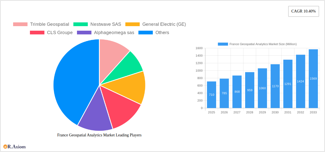
The French geospatial analytics market, valued at €0.71 billion in 2025, is poised for robust growth, exhibiting a Compound Annual Growth Rate (CAGR) of 10.40% from 2025 to 2033. This expansion is driven by increasing adoption of geospatial technologies across diverse sectors, including agriculture (precision farming), utilities (network optimization), defense (surveillance and intelligence), and government (urban planning and resource management). The market's growth is further fueled by advancements in data analytics techniques, particularly in areas like surface analysis, network analysis, and geovisualization. These advancements enable more insightful decision-making, improved operational efficiency, and better resource allocation across various applications. The integration of geospatial data with other data sources, such as IoT sensors and social media, is also significantly contributing to market expansion.
However, challenges remain. Data security and privacy concerns, coupled with the need for substantial investment in infrastructure and skilled personnel, could potentially restrain market growth to some extent. Despite these challenges, the ongoing digital transformation across various sectors and the increasing accessibility of geospatial data are expected to outweigh these limitations. The segment comprising surface analysis and network analysis is likely to dominate the market due to its widespread applicability across multiple verticals. Key players like Trimble Geospatial, ESRI Inc., and Bentley Systems Inc. are actively shaping the market landscape through technological innovation and strategic partnerships, fostering further market growth. The French government's initiatives in promoting digital infrastructure and data-driven decision-making will also significantly contribute to market expansion. The forecast period, 2025-2033, promises substantial growth driven by technological evolution and increasing adoption across various sectors.
France Geospatial Analytics Market: A Comprehensive Report (2019-2033)
This in-depth report provides a comprehensive analysis of the France Geospatial Analytics Market, offering invaluable insights for industry stakeholders, investors, and strategic decision-makers. The study covers the period from 2019 to 2033, with a focus on the 2025-2033 forecast period. The report leverages rigorous data analysis and expert insights to provide a clear understanding of market trends, growth drivers, challenges, and opportunities. Key market segments, leading players, and recent industry developments are meticulously examined. The market size is projected to reach xx Million by 2033, exhibiting a CAGR of xx% during the forecast period.
France Geospatial Analytics Market Market Concentration & Innovation
This section analyzes the competitive landscape of the French geospatial analytics market, examining market concentration, innovation drivers, regulatory frameworks, product substitutes, end-user trends, and merger & acquisition (M&A) activities.
The market exhibits a moderately concentrated structure, with a few major players holding significant market share. While exact market share figures for individual companies remain proprietary, we estimate that the top five players collectively account for approximately xx% of the market. This concentration is driven by the high capital investment required for research and development, along with the specialized expertise needed to develop and implement advanced geospatial solutions.
- Innovation Drivers: Technological advancements in areas such as AI, machine learning, and high-resolution satellite imagery are key innovation drivers. Furthermore, increasing demand for precise location-based services is fueling innovation in data analytics and visualization techniques.
- Regulatory Frameworks: Strict data privacy regulations and government mandates regarding data security are shaping the market's development. Compliance with these regulations is a key factor influencing technology adoption and vendor selection.
- Product Substitutes: While geospatial analytics offers unique capabilities, potential substitutes include traditional surveying methods and less sophisticated mapping technologies. However, the increasing need for accurate, timely, and comprehensive data is limiting the appeal of these substitutes.
- End-User Trends: Growing adoption of cloud-based solutions and a preference for integrated platforms are prominent end-user trends. There is also a rising demand for customized solutions tailored to specific industry needs.
- M&A Activities: The market has witnessed several M&A activities in recent years. Although exact deal values are often confidential, these acquisitions reflect a strategic drive to expand market reach, enhance technological capabilities, and consolidate market share. For instance, we anticipate approximately xx M&A deals with a total value of approximately xx Million over the forecast period.
France Geospatial Analytics Market Industry Trends & Insights
The France Geospatial Analytics Market is experiencing robust growth, driven by several key factors. Increasing urbanization, the need for improved infrastructure planning, and rising government investments in digital technologies are significantly impacting market expansion. The market is witnessing a shift towards cloud-based solutions, with a substantial increase in the adoption of Software-as-a-Service (SaaS) models. This trend is facilitated by increasing internet penetration and the availability of high-speed internet connectivity. Furthermore, the convergence of GIS (Geographic Information Systems) and other technologies such as IoT (Internet of Things) and AI is generating new opportunities for innovation.
The competitive landscape is characterized by both established players and emerging companies. Established players leverage their extensive experience and existing customer base, while emerging companies focus on niche solutions and disruptive technologies. The market exhibits a high degree of fragmentation, with a large number of both large multinational corporations and small specialized companies participating. This competitive landscape fosters innovation and keeps prices competitive, ultimately benefiting end-users. The market is projected to grow at a CAGR of xx% during the forecast period (2025-2033), driven primarily by government initiatives and the growing adoption of geospatial technologies across various sectors. Market penetration is expected to increase significantly across all end-user verticals, reflecting the expanding recognition of the value of geospatial data and analytics.

Dominant Markets & Segments in France Geospatial Analytics Market
The French geospatial analytics market is characterized by a diverse range of segments, each with its unique growth drivers and challenges. This section highlights the leading segments by end-user vertical and type.
By End-user Vertical:
- Government: This segment is the dominant market driver, fueled by substantial investments in infrastructure development, smart city initiatives, and environmental monitoring. Strong government support and large-scale projects are boosting growth.
- Real Estate and Construction: The need for efficient land management, precise site analysis, and risk assessment is driving the growth of this segment. Integration of 3D modeling and BIM (Building Information Modeling) is further accelerating adoption.
- Utility and Communication: This segment is experiencing growth due to the increasing demand for efficient network management, infrastructure planning, and improved service delivery.
- Defense and Intelligence: This segment presents opportunities driven by increasing national security needs, leading to investments in advanced geospatial intelligence solutions.
By Type:
- Surface Analysis: This is a primary segment given the need for detailed terrain analysis, particularly in construction and infrastructure projects.
- Network Analysis: The importance of network optimization across various sectors, especially utilities and transportation, is driving the growth of this segment.
- Geovisualization: This segment sees increased use across diverse fields, for communication, training, and strategic planning.
Key Drivers for Dominant Segments:
- Favorable Economic Policies: Government initiatives promoting technological innovation and digitalization are crucial for growth.
- Robust Infrastructure Development: Investments in national infrastructure projects fuel the demand for geospatial solutions.
- Increasing Urbanization: The rapid urbanization of French cities enhances the need for effective urban planning and management.
France Geospatial Analytics Market Product Developments
Recent product developments highlight a trend toward cloud-based, integrated platforms offering advanced analytical capabilities and enhanced visualization tools. These platforms are designed to meet the evolving needs of various sectors, offering customized solutions and seamless data integration. The integration of AI and machine learning is enabling more efficient data processing and analysis, providing valuable insights for decision-making. This aligns perfectly with market demand for cost-effective, accurate, and timely data-driven solutions.
Report Scope & Segmentation Analysis
This report segments the France Geospatial Analytics Market by end-user vertical (Agriculture, Utility and Communication, Defense and Intelligence, Government, Mining and Natural Resources, Automotive and Transportation, Healthcare, Real Estate and Construction, Other End-user Verticals) and by type (Surface Analysis, Network Analysis, Geovisualization). Each segment's growth projection, market size (in Millions), and competitive dynamics are analyzed, providing a comprehensive view of the market's structure and future prospects. For instance, the Real Estate and Construction segment is expected to witness significant growth due to increased construction activity and the adoption of advanced building information modeling techniques. The Government segment is poised for considerable expansion driven by large-scale infrastructure projects and investments in smart city initiatives.
Key Drivers of France Geospatial Analytics Market Growth
The market's growth is propelled by several key factors:
- Technological Advancements: Innovations in sensor technologies, satellite imagery, AI, and machine learning are enabling more efficient data acquisition and analysis.
- Government Initiatives: Government policies promoting the adoption of digital technologies and investments in infrastructure development are stimulating market expansion.
- Economic Growth: Overall economic growth in France is driving increased investment in various sectors, contributing to the demand for geospatial solutions.
Challenges in the France Geospatial Analytics Market Sector
The French geospatial analytics market faces several challenges:
- Data Security and Privacy Concerns: Strict data privacy regulations require robust security measures, increasing costs and complexity.
- High Initial Investment Costs: The implementation of advanced geospatial solutions necessitates significant upfront investments, potentially hindering smaller businesses.
- Data Integration Challenges: Integrating diverse data sources can be complex, requiring specialized expertise and robust data management systems. The estimated cost impact of these challenges is approximately xx Million annually.
Emerging Opportunities in France Geospatial Analytics Market
The market presents significant opportunities:
- Growth of Smart Cities: The development of smart city initiatives creates high demand for advanced geospatial analytics solutions.
- Expansion of IoT Applications: Integration of geospatial data with IoT devices offers new possibilities for real-time monitoring and analysis.
- Increased Adoption in Agriculture: Precision agriculture and environmental monitoring present significant opportunities for growth in this sector.
Leading Players in the France Geospatial Analytics Market Market
- Trimble Geospatial (Trimble Geospatial)
- Nestwave SAS
- General Electric (GE) (General Electric)
- CLS Groupe (CLS Groupe)
- Alphageomega sas
- ESRI Inc (ESRI Inc)
- Harris Corporation (Harris Corporation)
- Geomatys
- Bentley Systems Inc (Bentley Systems Inc)
- Intermap Technologies
Key Developments in France Geospatial Analytics Market Industry
- July 2023: GeoCue's partnership with Escadrone expands its European presence, particularly in France, offering advanced TrueView 3D Imaging Sensors and LP360 LiDAR Processing Software. This strengthens the market's technological capabilities.
- January 2023: The AFD's investment in Rwanda's geospatial hub indirectly impacts the French market by fostering international collaboration in geospatial technologies and potentially increasing demand for related services. This showcases the broader impact of international development initiatives on the French geospatial analytics market.
Strategic Outlook for France Geospatial Analytics Market Market
The France Geospatial Analytics Market is poised for sustained growth, driven by technological advancements, increasing government investment, and the expanding adoption of geospatial solutions across diverse sectors. The focus on cloud-based solutions, the integration of AI and machine learning, and the increasing demand for customized solutions will shape future market dynamics. The market presents lucrative opportunities for both established players and new entrants, fostering innovation and competition. This positive outlook indicates a promising future for the French geospatial analytics sector.
France Geospatial Analytics Market Segmentation
-
1. Type
- 1.1. Surface Analysis
- 1.2. Network Analysis
- 1.3. Geovisualization
-
2. End-user Vertical
- 2.1. Agriculture
- 2.2. Utility and Communication
- 2.3. Defense and Intelligence
- 2.4. Government
- 2.5. Mining and Natural Resources
- 2.6. Automotive and Transportation
- 2.7. Healthcare
- 2.8. Real Estate and Construction
- 2.9. Other End-user Verticals
France Geospatial Analytics Market Segmentation By Geography
- 1. France

France Geospatial Analytics Market REPORT HIGHLIGHTS
| Aspects | Details |
|---|---|
| Study Period | 2019-2033 |
| Base Year | 2024 |
| Estimated Year | 2025 |
| Forecast Period | 2025-2033 |
| Historical Period | 2019-2024 |
| Growth Rate | CAGR of 10.40% from 2019-2033 |
| Segmentation |
|
Table of Contents
- 1. Introduction
- 1.1. Research Scope
- 1.2. Market Segmentation
- 1.3. Research Methodology
- 1.4. Definitions and Assumptions
- 2. Executive Summary
- 2.1. Introduction
- 3. Market Dynamics
- 3.1. Introduction
- 3.2. Market Drivers
- 3.2.1. Advancement in Technology; Rising Awareness of Location Based Service
- 3.3. Market Restrains
- 3.3.1. High Initial Cost in Implementing Geospatial Analytics Solutions
- 3.4. Market Trends
- 3.4.1. Increasing Adoption of 5G in France is Boosting the Market Growth
- 4. Market Factor Analysis
- 4.1. Porters Five Forces
- 4.2. Supply/Value Chain
- 4.3. PESTEL analysis
- 4.4. Market Entropy
- 4.5. Patent/Trademark Analysis
- 5. France Geospatial Analytics Market Analysis, Insights and Forecast, 2019-2031
- 5.1. Market Analysis, Insights and Forecast - by Type
- 5.1.1. Surface Analysis
- 5.1.2. Network Analysis
- 5.1.3. Geovisualization
- 5.2. Market Analysis, Insights and Forecast - by End-user Vertical
- 5.2.1. Agriculture
- 5.2.2. Utility and Communication
- 5.2.3. Defense and Intelligence
- 5.2.4. Government
- 5.2.5. Mining and Natural Resources
- 5.2.6. Automotive and Transportation
- 5.2.7. Healthcare
- 5.2.8. Real Estate and Construction
- 5.2.9. Other End-user Verticals
- 5.3. Market Analysis, Insights and Forecast - by Region
- 5.3.1. France
- 5.1. Market Analysis, Insights and Forecast - by Type
- 6. Competitive Analysis
- 6.1. Market Share Analysis 2024
- 6.2. Company Profiles
- 6.2.1 Trimble Geospatial
- 6.2.1.1. Overview
- 6.2.1.2. Products
- 6.2.1.3. SWOT Analysis
- 6.2.1.4. Recent Developments
- 6.2.1.5. Financials (Based on Availability)
- 6.2.2 Nestwave SAS
- 6.2.2.1. Overview
- 6.2.2.2. Products
- 6.2.2.3. SWOT Analysis
- 6.2.2.4. Recent Developments
- 6.2.2.5. Financials (Based on Availability)
- 6.2.3 General Electric (GE)
- 6.2.3.1. Overview
- 6.2.3.2. Products
- 6.2.3.3. SWOT Analysis
- 6.2.3.4. Recent Developments
- 6.2.3.5. Financials (Based on Availability)
- 6.2.4 CLS Groupe
- 6.2.4.1. Overview
- 6.2.4.2. Products
- 6.2.4.3. SWOT Analysis
- 6.2.4.4. Recent Developments
- 6.2.4.5. Financials (Based on Availability)
- 6.2.5 Alphageomega sas
- 6.2.5.1. Overview
- 6.2.5.2. Products
- 6.2.5.3. SWOT Analysis
- 6.2.5.4. Recent Developments
- 6.2.5.5. Financials (Based on Availability)
- 6.2.6 ESRI Inc
- 6.2.6.1. Overview
- 6.2.6.2. Products
- 6.2.6.3. SWOT Analysis
- 6.2.6.4. Recent Developments
- 6.2.6.5. Financials (Based on Availability)
- 6.2.7 Harris Corporation
- 6.2.7.1. Overview
- 6.2.7.2. Products
- 6.2.7.3. SWOT Analysis
- 6.2.7.4. Recent Developments
- 6.2.7.5. Financials (Based on Availability)
- 6.2.8 Geomatys
- 6.2.8.1. Overview
- 6.2.8.2. Products
- 6.2.8.3. SWOT Analysis
- 6.2.8.4. Recent Developments
- 6.2.8.5. Financials (Based on Availability)
- 6.2.9 Bentley Systems Inc
- 6.2.9.1. Overview
- 6.2.9.2. Products
- 6.2.9.3. SWOT Analysis
- 6.2.9.4. Recent Developments
- 6.2.9.5. Financials (Based on Availability)
- 6.2.10 Intermap Technologies
- 6.2.10.1. Overview
- 6.2.10.2. Products
- 6.2.10.3. SWOT Analysis
- 6.2.10.4. Recent Developments
- 6.2.10.5. Financials (Based on Availability)
- 6.2.1 Trimble Geospatial
List of Figures
- Figure 1: France Geospatial Analytics Market Revenue Breakdown (Million, %) by Product 2024 & 2032
- Figure 2: France Geospatial Analytics Market Share (%) by Company 2024
List of Tables
- Table 1: France Geospatial Analytics Market Revenue Million Forecast, by Region 2019 & 2032
- Table 2: France Geospatial Analytics Market Revenue Million Forecast, by Type 2019 & 2032
- Table 3: France Geospatial Analytics Market Revenue Million Forecast, by End-user Vertical 2019 & 2032
- Table 4: France Geospatial Analytics Market Revenue Million Forecast, by Region 2019 & 2032
- Table 5: France Geospatial Analytics Market Revenue Million Forecast, by Country 2019 & 2032
- Table 6: France Geospatial Analytics Market Revenue Million Forecast, by Type 2019 & 2032
- Table 7: France Geospatial Analytics Market Revenue Million Forecast, by End-user Vertical 2019 & 2032
- Table 8: France Geospatial Analytics Market Revenue Million Forecast, by Country 2019 & 2032
Frequently Asked Questions
1. What is the projected Compound Annual Growth Rate (CAGR) of the France Geospatial Analytics Market?
The projected CAGR is approximately 10.40%.
2. Which companies are prominent players in the France Geospatial Analytics Market?
Key companies in the market include Trimble Geospatial, Nestwave SAS, General Electric (GE), CLS Groupe, Alphageomega sas, ESRI Inc, Harris Corporation, Geomatys, Bentley Systems Inc, Intermap Technologies.
3. What are the main segments of the France Geospatial Analytics Market?
The market segments include Type, End-user Vertical.
4. Can you provide details about the market size?
The market size is estimated to be USD 0.71 Million as of 2022.
5. What are some drivers contributing to market growth?
Advancement in Technology; Rising Awareness of Location Based Service.
6. What are the notable trends driving market growth?
Increasing Adoption of 5G in France is Boosting the Market Growth.
7. Are there any restraints impacting market growth?
High Initial Cost in Implementing Geospatial Analytics Solutions.
8. Can you provide examples of recent developments in the market?
July 2023: GeoCue, a leading provider of advanced geospatial software and hardware solutions, has partnered with Escadrone, an expert in autonomous robotics integration. This partnership marks an expansion of GeoCue's presence in the European market, particularly in France, where Escadrone will offer advanced-level TrueView 3D Imaging Sensors and LP360 LiDAR Processing Software. With this partnership, Escadrone will likely provide TrueView Lidar products and LP360 software, empowering its customers to enhance their surveying and mapping capabilities.
9. What pricing options are available for accessing the report?
Pricing options include single-user, multi-user, and enterprise licenses priced at USD 3800, USD 4500, and USD 5800 respectively.
10. Is the market size provided in terms of value or volume?
The market size is provided in terms of value, measured in Million.
11. Are there any specific market keywords associated with the report?
Yes, the market keyword associated with the report is "France Geospatial Analytics Market," which aids in identifying and referencing the specific market segment covered.
12. How do I determine which pricing option suits my needs best?
The pricing options vary based on user requirements and access needs. Individual users may opt for single-user licenses, while businesses requiring broader access may choose multi-user or enterprise licenses for cost-effective access to the report.
13. Are there any additional resources or data provided in the France Geospatial Analytics Market report?
While the report offers comprehensive insights, it's advisable to review the specific contents or supplementary materials provided to ascertain if additional resources or data are available.
14. How can I stay updated on further developments or reports in the France Geospatial Analytics Market?
To stay informed about further developments, trends, and reports in the France Geospatial Analytics Market, consider subscribing to industry newsletters, following relevant companies and organizations, or regularly checking reputable industry news sources and publications.
Methodology
Step 1 - Identification of Relevant Samples Size from Population Database


Step 2 - Approaches for Defining Global Market Size (Value, Volume* & Price*)

Note*: In applicable scenarios
Step 3 - Data Sources
Primary Research
- Web Analytics
- Survey Reports
- Research Institute
- Latest Research Reports
- Opinion Leaders
Secondary Research
- Annual Reports
- White Paper
- Latest Press Release
- Industry Association
- Paid Database
- Investor Presentations

Step 4 - Data Triangulation
Involves using different sources of information in order to increase the validity of a study
These sources are likely to be stakeholders in a program - participants, other researchers, program staff, other community members, and so on.
Then we put all data in single framework & apply various statistical tools to find out the dynamic on the market.
During the analysis stage, feedback from the stakeholder groups would be compared to determine areas of agreement as well as areas of divergence


