
Key Insights
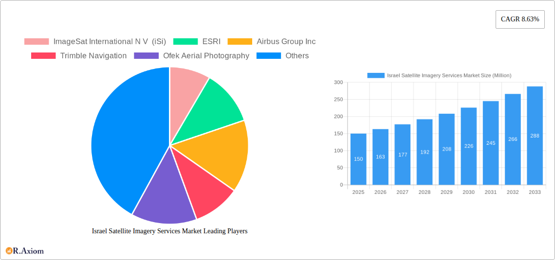
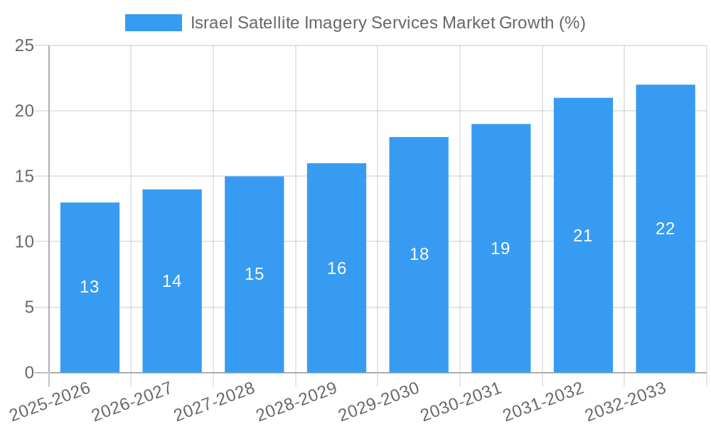
The Israel Satellite Imagery Services market, valued at approximately $150 million in 2025, is projected to experience robust growth, driven by a Compound Annual Growth Rate (CAGR) of 8.63% from 2025 to 2033. This expansion is fueled by several key factors. Firstly, the increasing adoption of satellite imagery across diverse sectors, including government initiatives for infrastructure development and national security, is a major driver. The construction, transportation, and agriculture sectors are increasingly reliant on precise geospatial data for planning, monitoring, and resource optimization. Secondly, advancements in satellite technology are leading to higher-resolution imagery, enhanced analytical capabilities, and more cost-effective solutions, making satellite imagery accessible to a broader range of users. Finally, the growing awareness of environmental concerns and the need for effective disaster management are contributing to the demand for satellite imagery for monitoring deforestation, pollution, and natural disasters.
However, challenges remain. The market faces restraints from factors such as data security concerns, high initial investment costs for acquiring and implementing satellite imagery technology, and the need for specialized expertise in data interpretation and analysis. Despite these hurdles, the overall outlook for the Israel Satellite Imagery Services market remains positive, with continued growth expected across all segments. The Government sector currently dominates the end-user segment, owing to its extensive use in national security and infrastructure projects. However, increasing private sector adoption, particularly within the construction and agriculture sectors, is expected to drive future market expansion. Major players like ImageSat International, ESRI, and Airbus are well-positioned to benefit from these trends, contributing to market consolidation and the introduction of innovative solutions.
Israel Satellite Imagery Services Market: A Comprehensive Report (2019-2033)
This in-depth report provides a comprehensive analysis of the Israel Satellite Imagery Services Market, offering invaluable insights for industry stakeholders, investors, and strategic decision-makers. The report covers the period from 2019 to 2033, with a focus on the forecast period of 2025-2033, using 2025 as the base year and estimated year. The market is segmented by application and end-user, revealing key growth drivers, challenges, and emerging opportunities. Market sizes are presented in Millions.
Israel Satellite Imagery Services Market Concentration & Innovation
The Israeli satellite imagery services market exhibits a moderately concentrated structure, with a few dominant players alongside several smaller, specialized firms. Market share dynamics are influenced by technological capabilities, government contracts, and the ability to deliver high-quality, timely data. While exact market share figures for individual companies are unavailable (xx), ImageSat International N V (iSi), Airbus Group Inc, and Google LLC are estimated to hold significant shares. Innovation is a key driver, fueled by advancements in sensor technology, data processing, and analytical capabilities. The regulatory framework, while supportive of national security objectives, also presents complexities for market access and data sharing. Product substitutes, such as aerial photography and drone-based imagery, offer some competition, but the unique capabilities of satellite imagery, particularly in terms of coverage area and resolution, maintain its dominance. End-user trends are shaped by increasing demand for geospatial data across various sectors, with governments, military, and the construction industries being major consumers. Mergers and acquisitions (M&A) activity has been moderate, with deal values estimated in the range of xx Million, driven by strategic expansion and technology integration.
- Market Concentration: Moderate, with a few major players.
- Innovation Drivers: Sensor technology, data processing, analytics.
- Regulatory Framework: Supportive of national security, with some complexities.
- Product Substitutes: Aerial photography, drone imagery.
- End-User Trends: Increasing demand from government, military, and construction.
- M&A Activity: Moderate activity, estimated deal values in the xx Million range.
Israel Satellite Imagery Services Market Industry Trends & Insights
The Israeli satellite imagery services market is experiencing robust growth, driven by increased demand for high-resolution imagery and advanced analytical capabilities. The Compound Annual Growth Rate (CAGR) during the forecast period (2025-2033) is projected to be xx%, indicating a significant expansion of the market. Technological disruptions, such as the introduction of improved sensors and AI-powered image processing, are accelerating market growth and driving innovation. Consumer preferences are increasingly focused on high-quality data, rapid delivery, and user-friendly analytical tools. Competitive dynamics are characterized by a blend of collaboration and competition, with companies forming strategic partnerships to leverage complementary technologies and expand their market reach while simultaneously competing to secure government contracts and large-scale projects. Market penetration is currently estimated at xx%, with significant potential for future growth across various sectors and applications. The success of the recent "Ofek-13" spy satellite launch highlights the importance of this sector for national security and its potential impact on market expansion.
Dominant Markets & Segments in Israel Satellite Imagery Services Market
The Government sector dominates the end-user segment of the Israeli satellite imagery services market, driven by robust defense spending and the national need for intelligence and security. The Geospatial Data Acquisition and Mapping application segment also holds significant market share, fueled by growing infrastructure projects and urban planning initiatives.
- Leading End-User Segment: Government (driven by defense, national security, and intelligence needs)
- Leading Application Segment: Geospatial Data Acquisition and Mapping (driven by infrastructure development and urban planning).
Key Drivers:
- Government: Significant defense spending, strategic national security imperatives.
- Geospatial Data Acquisition and Mapping: Urban planning, infrastructure development, construction projects.
- Military and Defense: Operational intelligence requirements.
- Construction: Precise mapping, site planning, progress monitoring.
The dominance of these segments is underpinned by several factors, including Israel's geopolitical context, robust technological capabilities within the country and strong government support for the aerospace sector.
Israel Satellite Imagery Services Market Product Developments
Recent advancements in sensor technology, including hyperspectral and radar imaging, have significantly enhanced the capabilities of satellite imagery, enabling more precise and detailed analysis. New platforms and software applications offer streamlined access to data and analytical tools, improving efficiency and reducing costs. This continuous product development, coupled with the rise of cloud-based solutions, creates a competitive edge and improved market fit, catering to diversified demands in terms of data access, processing, and analysis.
Report Scope & Segmentation Analysis
The report segments the Israel Satellite Imagery Services Market by Application (Geospatial Data Acquisition and Mapping, Natural Resource Management, Surveillance and Security, Conservation and Research, Disaster Management, Intelligence) and by End-User (Government, Construction, Transportation and Logistics, Military and Defense, Forestry and Agriculture, Others). Each segment is analyzed to provide market size, growth projections, and competitive dynamics. For example, the Geospatial Data Acquisition and Mapping segment is projected to experience strong growth due to increased infrastructure development, while the Surveillance and Security segment is driven by national security needs.
Key Drivers of Israel Satellite Imagery Services Market Growth
The growth of the Israeli satellite imagery services market is propelled by several key factors. These include increasing government spending on defense and security, the ongoing need for precise geospatial data for urban planning and infrastructure development, and the rapid technological advancements in satellite imagery technology, offering higher resolution and analytical capabilities. Additionally, the rising adoption of cloud-based solutions for data access and processing is enhancing efficiency and driving wider market access.
Challenges in the Israel Satellite Imagery Services Market Sector
Challenges for the market include stringent regulatory requirements for data access and usage, particularly for sensitive data related to national security. Competition from international providers with established market presence and technological advancements represent additional challenges. The cost of developing and launching new satellites and maintaining existing infrastructure poses another significant hurdle. Supply chain disruptions and dependencies on international components can also impact market growth. The estimated impact of these challenges on market growth is xx%
Emerging Opportunities in Israel Satellite Imagery Services Market
Emerging opportunities arise from the growing adoption of AI-powered analytics in image processing, opening avenues for more sophisticated insights from satellite data. The integration of satellite imagery with other data sources (e.g., IoT sensors) creates further opportunities for comprehensive data-driven decision-making. New applications are emerging in areas such as precision agriculture and environmental monitoring, expanding market potential. Expansion into international markets and collaborative partnerships with international players can generate new revenue streams and further accelerate market growth.
Leading Players in the Israel Satellite Imagery Services Market Market
- ImageSat International N V (iSi) [xx]
- ESRI [www.esri.com]
- Airbus Group Inc [www.airbus.com]
- Trimble Navigation [www.trimble.com]
- Ofek Aerial Photography [xx]
- A TAL Satellite Imagery [xx]
- Google LLC [www.google.com]
- L3 Harris corporation [www.l3harris.com]
Key Developments in Israel Satellite Imagery Services Market Industry
- March 2023: Successful launch of the "Ofek-13" spy satellite, enhancing intelligence gathering capabilities.
- July 2023: Maxar Technologies unveiled its Maxar Geospatial Platform (MGP), improving accessibility to advanced geospatial data and analytics.
These developments significantly enhance data acquisition and analytical capabilities within the Israeli satellite imagery market and are expected to positively influence market growth and competitiveness.
Strategic Outlook for Israel Satellite Imagery Services Market Market
The Israeli satellite imagery services market holds significant growth potential driven by continued technological advancements, increasing demand from government and commercial sectors, and the country's strategic geopolitical location. Further market expansion is expected through increased private sector investment, the development of innovative applications, and strategic partnerships with global players. The focus on data security and compliance will remain crucial for continued growth in this sensitive sector.
Israel Satellite Imagery Services Market Segmentation
-
1. Application
- 1.1. Geospatial Data Acquisition and Mapping
- 1.2. Natural Resource Management
- 1.3. Surveillance and Security
- 1.4. Conservation and Research
- 1.5. Disaster Management
- 1.6. Intelligence
-
2. End-User
- 2.1. Government
- 2.2. Construction
- 2.3. Transportation and Logistics
- 2.4. Military and Defense
- 2.5. Forestry and Agriculture
- 2.6. Others
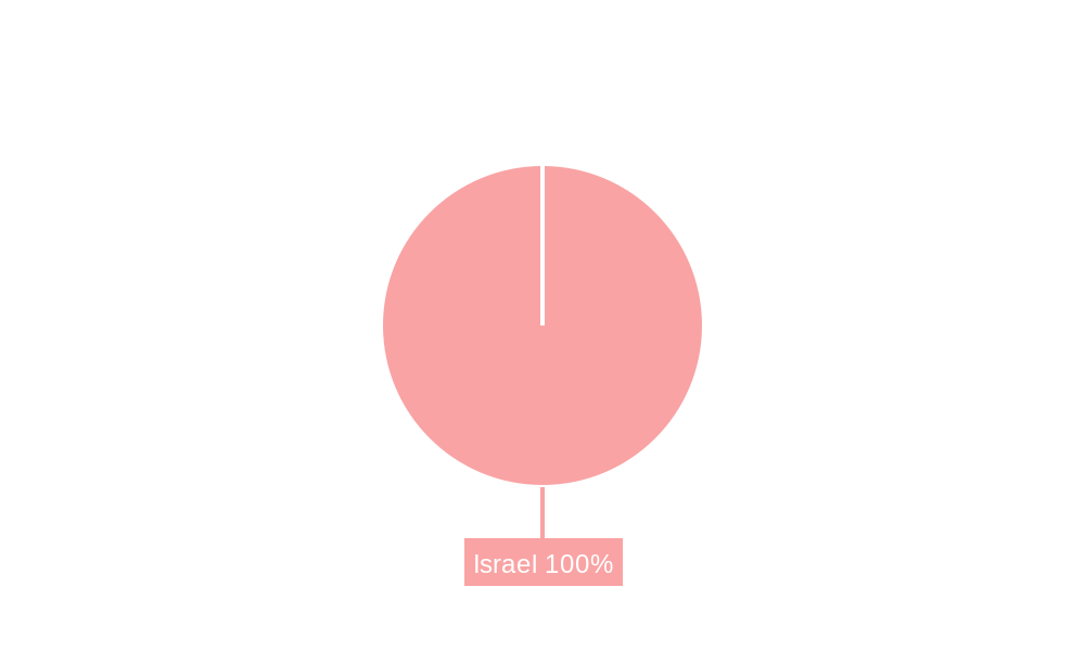
Israel Satellite Imagery Services Market Segmentation By Geography
- 1. Israel
Israel Satellite Imagery Services Market REPORT HIGHLIGHTS
| Aspects | Details |
|---|---|
| Study Period | 2019-2033 |
| Base Year | 2024 |
| Estimated Year | 2025 |
| Forecast Period | 2025-2033 |
| Historical Period | 2019-2024 |
| Growth Rate | CAGR of 8.63% from 2019-2033 |
| Segmentation |
|
Table of Contents
- 1. Introduction
- 1.1. Research Scope
- 1.2. Market Segmentation
- 1.3. Research Methodology
- 1.4. Definitions and Assumptions
- 2. Executive Summary
- 2.1. Introduction
- 3. Market Dynamics
- 3.1. Introduction
- 3.2. Market Drivers
- 3.2.1. Increasing Adoption of Location-based Services; Satellite data usage is increasing
- 3.3. Market Restrains
- 3.3.1. Strict government regulations; High-resolution Images Offered by Other Imaging Technologies
- 3.4. Market Trends
- 3.4.1. Surveillance and Security is Expected to Hold Significant Share
- 4. Market Factor Analysis
- 4.1. Porters Five Forces
- 4.2. Supply/Value Chain
- 4.3. PESTEL analysis
- 4.4. Market Entropy
- 4.5. Patent/Trademark Analysis
- 5. Israel Satellite Imagery Services Market Analysis, Insights and Forecast, 2019-2031
- 5.1. Market Analysis, Insights and Forecast - by Application
- 5.1.1. Geospatial Data Acquisition and Mapping
- 5.1.2. Natural Resource Management
- 5.1.3. Surveillance and Security
- 5.1.4. Conservation and Research
- 5.1.5. Disaster Management
- 5.1.6. Intelligence
- 5.2. Market Analysis, Insights and Forecast - by End-User
- 5.2.1. Government
- 5.2.2. Construction
- 5.2.3. Transportation and Logistics
- 5.2.4. Military and Defense
- 5.2.5. Forestry and Agriculture
- 5.2.6. Others
- 5.3. Market Analysis, Insights and Forecast - by Region
- 5.3.1. Israel
- 5.1. Market Analysis, Insights and Forecast - by Application
- 6. Competitive Analysis
- 6.1. Market Share Analysis 2024
- 6.2. Company Profiles
- 6.2.1 ImageSat International N V (iSi)
- 6.2.1.1. Overview
- 6.2.1.2. Products
- 6.2.1.3. SWOT Analysis
- 6.2.1.4. Recent Developments
- 6.2.1.5. Financials (Based on Availability)
- 6.2.2 ESRI
- 6.2.2.1. Overview
- 6.2.2.2. Products
- 6.2.2.3. SWOT Analysis
- 6.2.2.4. Recent Developments
- 6.2.2.5. Financials (Based on Availability)
- 6.2.3 Airbus Group Inc
- 6.2.3.1. Overview
- 6.2.3.2. Products
- 6.2.3.3. SWOT Analysis
- 6.2.3.4. Recent Developments
- 6.2.3.5. Financials (Based on Availability)
- 6.2.4 Trimble Navigation
- 6.2.4.1. Overview
- 6.2.4.2. Products
- 6.2.4.3. SWOT Analysis
- 6.2.4.4. Recent Developments
- 6.2.4.5. Financials (Based on Availability)
- 6.2.5 Ofek Aerial Photography
- 6.2.5.1. Overview
- 6.2.5.2. Products
- 6.2.5.3. SWOT Analysis
- 6.2.5.4. Recent Developments
- 6.2.5.5. Financials (Based on Availability)
- 6.2.6 A TAL Satellite Imagery
- 6.2.6.1. Overview
- 6.2.6.2. Products
- 6.2.6.3. SWOT Analysis
- 6.2.6.4. Recent Developments
- 6.2.6.5. Financials (Based on Availability)
- 6.2.7 Google LLC
- 6.2.7.1. Overview
- 6.2.7.2. Products
- 6.2.7.3. SWOT Analysis
- 6.2.7.4. Recent Developments
- 6.2.7.5. Financials (Based on Availability)
- 6.2.8 L3 Harris corporation
- 6.2.8.1. Overview
- 6.2.8.2. Products
- 6.2.8.3. SWOT Analysis
- 6.2.8.4. Recent Developments
- 6.2.8.5. Financials (Based on Availability)
- 6.2.1 ImageSat International N V (iSi)
List of Figures
- Figure 1: Israel Satellite Imagery Services Market Revenue Breakdown (Million, %) by Product 2024 & 2032
- Figure 2: Israel Satellite Imagery Services Market Share (%) by Company 2024
List of Tables
- Table 1: Israel Satellite Imagery Services Market Revenue Million Forecast, by Region 2019 & 2032
- Table 2: Israel Satellite Imagery Services Market Revenue Million Forecast, by Application 2019 & 2032
- Table 3: Israel Satellite Imagery Services Market Revenue Million Forecast, by End-User 2019 & 2032
- Table 4: Israel Satellite Imagery Services Market Revenue Million Forecast, by Region 2019 & 2032
- Table 5: Israel Satellite Imagery Services Market Revenue Million Forecast, by Country 2019 & 2032
- Table 6: Israel Satellite Imagery Services Market Revenue Million Forecast, by Application 2019 & 2032
- Table 7: Israel Satellite Imagery Services Market Revenue Million Forecast, by End-User 2019 & 2032
- Table 8: Israel Satellite Imagery Services Market Revenue Million Forecast, by Country 2019 & 2032
Frequently Asked Questions
1. What is the projected Compound Annual Growth Rate (CAGR) of the Israel Satellite Imagery Services Market?
The projected CAGR is approximately 8.63%.
2. Which companies are prominent players in the Israel Satellite Imagery Services Market?
Key companies in the market include ImageSat International N V (iSi), ESRI, Airbus Group Inc, Trimble Navigation, Ofek Aerial Photography, A TAL Satellite Imagery, Google LLC, L3 Harris corporation.
3. What are the main segments of the Israel Satellite Imagery Services Market?
The market segments include Application, End-User.
4. Can you provide details about the market size?
The market size is estimated to be USD XX Million as of 2022.
5. What are some drivers contributing to market growth?
Increasing Adoption of Location-based Services; Satellite data usage is increasing.
6. What are the notable trends driving market growth?
Surveillance and Security is Expected to Hold Significant Share.
7. Are there any restraints impacting market growth?
Strict government regulations; High-resolution Images Offered by Other Imaging Technologies.
8. Can you provide examples of recent developments in the market?
July 2023: Maxar Technologies, a leading provider of comprehensive space services and secure, precise geospatial intelligence, officially unveiled its groundbreaking Maxar Geospatial Platform (MGP). This cutting-edge platform revolutionizes the accessibility of advanced Earth intelligence, streamlining the process of discovering, acquiring, and integrating geospatial data and analytics. MGP empowers users with seamless access to Maxar's unparalleled geospatial content, which encompasses high-resolution satellite imagery, visually striking imagery base maps, intricate 3D models, readily analyzable data, and image-based change detection and analytical results.
9. What pricing options are available for accessing the report?
Pricing options include single-user, multi-user, and enterprise licenses priced at USD 3800, USD 4500, and USD 5800 respectively.
10. Is the market size provided in terms of value or volume?
The market size is provided in terms of value, measured in Million.
11. Are there any specific market keywords associated with the report?
Yes, the market keyword associated with the report is "Israel Satellite Imagery Services Market," which aids in identifying and referencing the specific market segment covered.
12. How do I determine which pricing option suits my needs best?
The pricing options vary based on user requirements and access needs. Individual users may opt for single-user licenses, while businesses requiring broader access may choose multi-user or enterprise licenses for cost-effective access to the report.
13. Are there any additional resources or data provided in the Israel Satellite Imagery Services Market report?
While the report offers comprehensive insights, it's advisable to review the specific contents or supplementary materials provided to ascertain if additional resources or data are available.
14. How can I stay updated on further developments or reports in the Israel Satellite Imagery Services Market?
To stay informed about further developments, trends, and reports in the Israel Satellite Imagery Services Market, consider subscribing to industry newsletters, following relevant companies and organizations, or regularly checking reputable industry news sources and publications.
Methodology
Step 1 - Identification of Relevant Samples Size from Population Database


Step 2 - Approaches for Defining Global Market Size (Value, Volume* & Price*)

Note*: In applicable scenarios
Step 3 - Data Sources
Primary Research
- Web Analytics
- Survey Reports
- Research Institute
- Latest Research Reports
- Opinion Leaders
Secondary Research
- Annual Reports
- White Paper
- Latest Press Release
- Industry Association
- Paid Database
- Investor Presentations

Step 4 - Data Triangulation
Involves using different sources of information in order to increase the validity of a study
These sources are likely to be stakeholders in a program - participants, other researchers, program staff, other community members, and so on.
Then we put all data in single framework & apply various statistical tools to find out the dynamic on the market.
During the analysis stage, feedback from the stakeholder groups would be compared to determine areas of agreement as well as areas of divergence


