
Key Insights
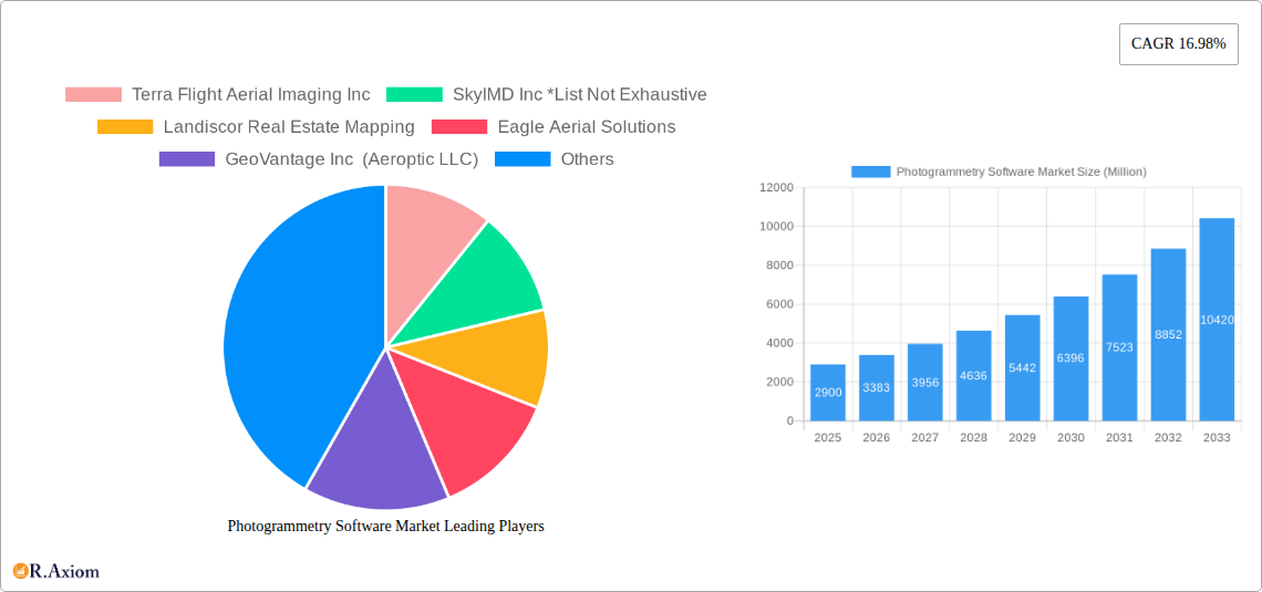
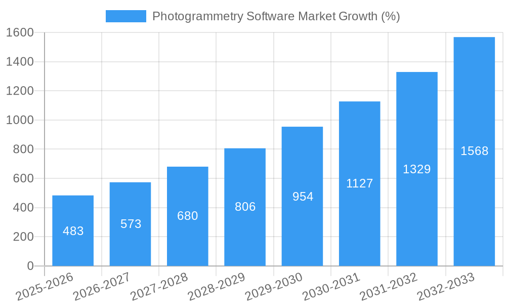
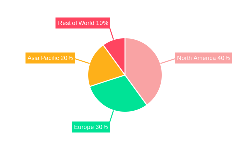
The Photogrammetry Software market, valued at $2.9 billion in 2025, is experiencing robust growth, projected to expand at a Compound Annual Growth Rate (CAGR) of 16.98% from 2025 to 2033. This surge is driven by increasing adoption across diverse sectors, including construction, aerospace & defense, and energy. The rising need for precise 3D models for infrastructure planning, asset management, and environmental monitoring fuels market expansion. Advancements in drone technology and the availability of high-resolution imagery further contribute to this growth. Segmentation reveals significant opportunities within the fixed-wing aircraft and UAV/drone platforms, with geospatial mapping and infrastructure planning dominating application areas. Major players like Terra Flight Aerial Imaging, SkyIMD, and Fugro are leading innovation and market penetration, driving competition and fostering technological advancements. Geographic expansion is expected, with North America and Europe maintaining a strong market share, while the Asia-Pacific region presents significant growth potential due to increasing infrastructure development and government initiatives.
The market's growth trajectory is influenced by several factors. The increasing affordability of photogrammetry software and the ease of use of user-friendly interfaces are broadening its accessibility. Furthermore, the growing demand for accurate and detailed data for various applications, such as precision agriculture and disaster management, is contributing to the market's expansion. While data security and privacy concerns represent potential restraints, the industry is actively addressing these challenges through the development of robust security protocols and data encryption techniques. The ongoing integration of Artificial Intelligence (AI) and Machine Learning (ML) capabilities into photogrammetry software promises further advancements in automation and efficiency, driving future market growth. This includes automated feature extraction, improved accuracy, and reduced processing times. The competitive landscape is characterized by both established players and emerging startups, fostering innovation and a dynamic market environment.
This in-depth report provides a comprehensive analysis of the Photogrammetry Software Market, offering valuable insights for industry stakeholders, investors, and researchers. Covering the period 2019-2033, with a base year of 2025 and a forecast period of 2025-2033, this report meticulously examines market dynamics, growth drivers, challenges, and opportunities. The report segments the market by end-user industry, platform type, and application, providing granular data and analysis for informed decision-making. Key players like Terra Flight Aerial Imaging Inc, SkyIMD Inc, Landiscor Real Estate Mapping, and others are profiled, showcasing their strategies and market positions.
Photogrammetry Software Market Market Concentration & Innovation
The photogrammetry software market exhibits a moderately concentrated landscape, with a few major players holding significant market share. However, the emergence of innovative startups and the increasing adoption of open-source solutions are fostering competition. The market is characterized by continuous innovation, driven by advancements in sensor technology, AI-powered image processing, and cloud-based solutions. Regulatory frameworks, particularly those concerning data privacy and security, are increasingly impacting market operations. The market witnesses substantial M&A activity, with deal values exceeding xx Million in recent years, reflecting the strategic importance of this technology. For example, the acquisition of Company X by Company Y in 2023 for xx Million significantly altered the market landscape. The trend of increasing use of UAVs (Unmanned Aerial Vehicles) is a major innovation driver, leading to higher-resolution and more readily available data. Product substitutes, like traditional surveying methods, are losing market share due to the cost-effectiveness and efficiency of photogrammetry. End-user trends, such as the increasing demand for 3D modeling and digital twins, are pushing market growth.
- Market Share: Top 5 players hold approximately xx% of the market share.
- M&A Activity: xx deals closed in the past 5 years, with an average deal value of xx Million.
- Innovation Drivers: AI-powered image processing, Cloud-based solutions, UAV Integration.
- Regulatory Impact: GDPR, data security regulations shaping data handling practices.
Photogrammetry Software Market Industry Trends & Insights
The photogrammetry software market is experiencing robust growth, with a CAGR of xx% projected during the forecast period (2025-2033). This growth is fueled by increasing adoption across various sectors, such as construction, infrastructure, and environmental monitoring. Technological disruptions, particularly in the areas of AI and machine learning, are enhancing the accuracy and efficiency of photogrammetry software. Consumer preferences are shifting toward cloud-based solutions that offer scalability and accessibility. Competitive dynamics are characterized by intense rivalry among established players and the emergence of innovative startups. The market penetration rate is expected to reach xx% by 2033, driven by the increasing awareness of the benefits of photogrammetry and the decreasing cost of hardware and software. The integration of advanced algorithms for point cloud processing and mesh generation is improving overall productivity. Furthermore, advancements in real-time processing capabilities are opening up new avenues for immediate data visualization and decision-making.
Dominant Markets & Segments in Photogrammetry Software Market
The Construction sector currently dominates the photogrammetry software market, driven by the rising need for accurate site surveys, progress monitoring, and 3D modeling. The North American region holds the largest market share, followed by Europe. Within the platform type segment, UAVs/Drones are experiencing the fastest growth due to their cost-effectiveness and flexibility. Geospatial mapping and infrastructure planning applications are the major drivers within the application segment.
- Leading Region: North America
- Dominant End-user Industry: Construction
- Fastest-Growing Platform Type: UAVs/Drones
- Key Application Drivers:
- Construction: Need for accurate site surveys, progress monitoring, and 3D modeling.
- Infrastructure Planning: Detailed design, asset management, and risk assessment.
- Government: Urban planning, land management, and disaster response.
- Oil & Gas: Pipeline inspection, infrastructure monitoring, and exploration.
Photogrammetry Software Market Product Developments
Recent product innovations focus on enhancing automation, accuracy, and ease of use. This includes the integration of AI algorithms for automated feature extraction and 3D model generation, as well as user-friendly interfaces that simplify data processing and visualization. These developments are driving market penetration and improving the competitive advantages of leading players. The trend towards cloud-based platforms is enabling collaboration and data sharing across teams, further improving efficiency and accessibility.
Report Scope & Segmentation Analysis
This report provides a comprehensive analysis of the photogrammetry software market, segmented by end-user industry (Construction, Aerospace and Defense, Government, Oil and Gas, Energy and Power, Agriculture, Other End-user Industries), platform type (Fixed-wing Aircraft, Helicopters, UAVs/Drones, Other Platform Types), and application (Geospatial Mapping, Infrastructure Planning, Asset Inventory Management, Environmental Monitoring, National and Urban Mapping, Surveillance and Monitoring, Disaster Management, Other Applications). Each segment's growth projections, market sizes, and competitive dynamics are analyzed in detail. Market size for the construction segment is expected to reach xx Million by 2033, while the UAV/Drone segment is projected to have the highest CAGR amongst platform types.
Key Drivers of Photogrammetry Software Market Growth
The market's growth is driven by several factors, including increasing demand for precise data in various industries, advancements in sensor technology leading to higher resolution and accuracy, the rising adoption of UAVs for data acquisition, decreasing costs of hardware and software, and government initiatives promoting the use of geospatial data. The development of user-friendly software and cloud-based platforms is also facilitating wider market adoption.
Challenges in the Photogrammetry Software Market Sector
The photogrammetry software market faces challenges including the need for specialized expertise, the complexity of data processing, concerns about data security and privacy, and the potential for inaccurate data due to weather conditions or limitations in sensor technology. Competition from established players and new entrants also poses a challenge.
Emerging Opportunities in Photogrammetry Software Market
Emerging opportunities lie in the development of AI-powered automated processing, the integration of photogrammetry with other technologies like GIS and BIM, the expansion into new markets such as autonomous vehicles and robotics, and the increasing demand for real-time data processing and analysis. The development of solutions tailored to specific vertical markets will also create significant opportunities.
Leading Players in the Photogrammetry Software Market Market
- Terra Flight Aerial Imaging Inc
- SkyIMD Inc
- Landiscor Real Estate Mapping
- Eagle Aerial Solutions
- GeoVantage Inc (Aeroptic LLC)
- Digital Aerial Solutions LLC
- Fugro Ltd
- Aerobotics (Pty) Ltd
- Nearmap Ltd
- Airobotics GmbH (ONDAS Holdings)
- Kucera International Inc
- Dronegenuity
- Global UAV Technologies Ltd (High Eye Aerial Imaging Inc)
- Eagle View Technologies Inc
- Cooper Aerial Surveys Co
Key Developments in Photogrammetry Software Market Industry
- January 2023: Company A launched a new AI-powered photogrammetry software.
- May 2022: Company B acquired Company C, expanding its market reach.
- October 2021: New regulations impacting data privacy were introduced.
Strategic Outlook for Photogrammetry Software Market Market
The photogrammetry software market presents significant growth potential, driven by technological advancements, increasing demand across multiple sectors, and supportive government policies. The continued development of AI-powered solutions, cloud-based platforms, and user-friendly interfaces will be key to capturing market share and driving further growth. Expansion into new applications and markets will also offer significant opportunities for market players.
Photogrammetry Software Market Segmentation
-
1. Platform Type
- 1.1. Fixed-wing Aircraft
- 1.2. Helicopters
- 1.3. UAVs/Drones
- 1.4. Other Platform Types
-
2. Application
- 2.1. Geospatial Mapping
- 2.2. Infrastructure Planning
- 2.3. Asset Inventory Management
- 2.4. Environmental Monitoring
- 2.5. National and Urban Mapping
- 2.6. Surveillance and Monitoring
- 2.7. Disaster Management
- 2.8. Other Applications
-
3. End-user Industry
- 3.1. Construction
- 3.2. Aerospace and Defense
- 3.3. Government
- 3.4. Oil and Gas
- 3.5. Energy and Power
- 3.6. Agriculture
- 3.7. Other End-user Industries
Photogrammetry Software Market Segmentation By Geography
- 1. North America
- 2. Europe
- 3. Asia Pacific
- 4. Rest of the World
Photogrammetry Software Market REPORT HIGHLIGHTS
| Aspects | Details |
|---|---|
| Study Period | 2019-2033 |
| Base Year | 2024 |
| Estimated Year | 2025 |
| Forecast Period | 2025-2033 |
| Historical Period | 2019-2024 |
| Growth Rate | CAGR of 16.98% from 2019-2033 |
| Segmentation |
|
Table of Contents
- 1. Introduction
- 1.1. Research Scope
- 1.2. Market Segmentation
- 1.3. Research Methodology
- 1.4. Definitions and Assumptions
- 2. Executive Summary
- 2.1. Introduction
- 3. Market Dynamics
- 3.1. Introduction
- 3.2. Market Drivers
- 3.2.1. Rise of Location-based Services; Increasing Demand from Diversified Applications
- 3.3. Market Restrains
- 3.3.1. Security and Privacy Issues; Stringent Government Regulations
- 3.4. Market Trends
- 3.4.1. The Government is Expected to be the Largest End User of Aerial Imaging
- 4. Market Factor Analysis
- 4.1. Porters Five Forces
- 4.2. Supply/Value Chain
- 4.3. PESTEL analysis
- 4.4. Market Entropy
- 4.5. Patent/Trademark Analysis
- 5. Global Photogrammetry Software Market Analysis, Insights and Forecast, 2019-2031
- 5.1. Market Analysis, Insights and Forecast - by Platform Type
- 5.1.1. Fixed-wing Aircraft
- 5.1.2. Helicopters
- 5.1.3. UAVs/Drones
- 5.1.4. Other Platform Types
- 5.2. Market Analysis, Insights and Forecast - by Application
- 5.2.1. Geospatial Mapping
- 5.2.2. Infrastructure Planning
- 5.2.3. Asset Inventory Management
- 5.2.4. Environmental Monitoring
- 5.2.5. National and Urban Mapping
- 5.2.6. Surveillance and Monitoring
- 5.2.7. Disaster Management
- 5.2.8. Other Applications
- 5.3. Market Analysis, Insights and Forecast - by End-user Industry
- 5.3.1. Construction
- 5.3.2. Aerospace and Defense
- 5.3.3. Government
- 5.3.4. Oil and Gas
- 5.3.5. Energy and Power
- 5.3.6. Agriculture
- 5.3.7. Other End-user Industries
- 5.4. Market Analysis, Insights and Forecast - by Region
- 5.4.1. North America
- 5.4.2. Europe
- 5.4.3. Asia Pacific
- 5.4.4. Rest of the World
- 5.1. Market Analysis, Insights and Forecast - by Platform Type
- 6. North America Photogrammetry Software Market Analysis, Insights and Forecast, 2019-2031
- 6.1. Market Analysis, Insights and Forecast - by Platform Type
- 6.1.1. Fixed-wing Aircraft
- 6.1.2. Helicopters
- 6.1.3. UAVs/Drones
- 6.1.4. Other Platform Types
- 6.2. Market Analysis, Insights and Forecast - by Application
- 6.2.1. Geospatial Mapping
- 6.2.2. Infrastructure Planning
- 6.2.3. Asset Inventory Management
- 6.2.4. Environmental Monitoring
- 6.2.5. National and Urban Mapping
- 6.2.6. Surveillance and Monitoring
- 6.2.7. Disaster Management
- 6.2.8. Other Applications
- 6.3. Market Analysis, Insights and Forecast - by End-user Industry
- 6.3.1. Construction
- 6.3.2. Aerospace and Defense
- 6.3.3. Government
- 6.3.4. Oil and Gas
- 6.3.5. Energy and Power
- 6.3.6. Agriculture
- 6.3.7. Other End-user Industries
- 6.1. Market Analysis, Insights and Forecast - by Platform Type
- 7. Europe Photogrammetry Software Market Analysis, Insights and Forecast, 2019-2031
- 7.1. Market Analysis, Insights and Forecast - by Platform Type
- 7.1.1. Fixed-wing Aircraft
- 7.1.2. Helicopters
- 7.1.3. UAVs/Drones
- 7.1.4. Other Platform Types
- 7.2. Market Analysis, Insights and Forecast - by Application
- 7.2.1. Geospatial Mapping
- 7.2.2. Infrastructure Planning
- 7.2.3. Asset Inventory Management
- 7.2.4. Environmental Monitoring
- 7.2.5. National and Urban Mapping
- 7.2.6. Surveillance and Monitoring
- 7.2.7. Disaster Management
- 7.2.8. Other Applications
- 7.3. Market Analysis, Insights and Forecast - by End-user Industry
- 7.3.1. Construction
- 7.3.2. Aerospace and Defense
- 7.3.3. Government
- 7.3.4. Oil and Gas
- 7.3.5. Energy and Power
- 7.3.6. Agriculture
- 7.3.7. Other End-user Industries
- 7.1. Market Analysis, Insights and Forecast - by Platform Type
- 8. Asia Pacific Photogrammetry Software Market Analysis, Insights and Forecast, 2019-2031
- 8.1. Market Analysis, Insights and Forecast - by Platform Type
- 8.1.1. Fixed-wing Aircraft
- 8.1.2. Helicopters
- 8.1.3. UAVs/Drones
- 8.1.4. Other Platform Types
- 8.2. Market Analysis, Insights and Forecast - by Application
- 8.2.1. Geospatial Mapping
- 8.2.2. Infrastructure Planning
- 8.2.3. Asset Inventory Management
- 8.2.4. Environmental Monitoring
- 8.2.5. National and Urban Mapping
- 8.2.6. Surveillance and Monitoring
- 8.2.7. Disaster Management
- 8.2.8. Other Applications
- 8.3. Market Analysis, Insights and Forecast - by End-user Industry
- 8.3.1. Construction
- 8.3.2. Aerospace and Defense
- 8.3.3. Government
- 8.3.4. Oil and Gas
- 8.3.5. Energy and Power
- 8.3.6. Agriculture
- 8.3.7. Other End-user Industries
- 8.1. Market Analysis, Insights and Forecast - by Platform Type
- 9. Rest of the World Photogrammetry Software Market Analysis, Insights and Forecast, 2019-2031
- 9.1. Market Analysis, Insights and Forecast - by Platform Type
- 9.1.1. Fixed-wing Aircraft
- 9.1.2. Helicopters
- 9.1.3. UAVs/Drones
- 9.1.4. Other Platform Types
- 9.2. Market Analysis, Insights and Forecast - by Application
- 9.2.1. Geospatial Mapping
- 9.2.2. Infrastructure Planning
- 9.2.3. Asset Inventory Management
- 9.2.4. Environmental Monitoring
- 9.2.5. National and Urban Mapping
- 9.2.6. Surveillance and Monitoring
- 9.2.7. Disaster Management
- 9.2.8. Other Applications
- 9.3. Market Analysis, Insights and Forecast - by End-user Industry
- 9.3.1. Construction
- 9.3.2. Aerospace and Defense
- 9.3.3. Government
- 9.3.4. Oil and Gas
- 9.3.5. Energy and Power
- 9.3.6. Agriculture
- 9.3.7. Other End-user Industries
- 9.1. Market Analysis, Insights and Forecast - by Platform Type
- 10. North America Photogrammetry Software Market Analysis, Insights and Forecast, 2019-2031
- 10.1. Market Analysis, Insights and Forecast - By Country/Sub-region
- 10.1.1.
- 11. Europe Photogrammetry Software Market Analysis, Insights and Forecast, 2019-2031
- 11.1. Market Analysis, Insights and Forecast - By Country/Sub-region
- 11.1.1.
- 12. Asia Pacific Photogrammetry Software Market Analysis, Insights and Forecast, 2019-2031
- 12.1. Market Analysis, Insights and Forecast - By Country/Sub-region
- 12.1.1.
- 13. Rest of the World Photogrammetry Software Market Analysis, Insights and Forecast, 2019-2031
- 13.1. Market Analysis, Insights and Forecast - By Country/Sub-region
- 13.1.1.
- 14. Competitive Analysis
- 14.1. Global Market Share Analysis 2024
- 14.2. Company Profiles
- 14.2.1 Terra Flight Aerial Imaging Inc
- 14.2.1.1. Overview
- 14.2.1.2. Products
- 14.2.1.3. SWOT Analysis
- 14.2.1.4. Recent Developments
- 14.2.1.5. Financials (Based on Availability)
- 14.2.2 SkyIMD Inc *List Not Exhaustive
- 14.2.2.1. Overview
- 14.2.2.2. Products
- 14.2.2.3. SWOT Analysis
- 14.2.2.4. Recent Developments
- 14.2.2.5. Financials (Based on Availability)
- 14.2.3 Landiscor Real Estate Mapping
- 14.2.3.1. Overview
- 14.2.3.2. Products
- 14.2.3.3. SWOT Analysis
- 14.2.3.4. Recent Developments
- 14.2.3.5. Financials (Based on Availability)
- 14.2.4 Eagle Aerial Solutions
- 14.2.4.1. Overview
- 14.2.4.2. Products
- 14.2.4.3. SWOT Analysis
- 14.2.4.4. Recent Developments
- 14.2.4.5. Financials (Based on Availability)
- 14.2.5 GeoVantage Inc (Aeroptic LLC)
- 14.2.5.1. Overview
- 14.2.5.2. Products
- 14.2.5.3. SWOT Analysis
- 14.2.5.4. Recent Developments
- 14.2.5.5. Financials (Based on Availability)
- 14.2.6 Digital Aerial Solutions LLC
- 14.2.6.1. Overview
- 14.2.6.2. Products
- 14.2.6.3. SWOT Analysis
- 14.2.6.4. Recent Developments
- 14.2.6.5. Financials (Based on Availability)
- 14.2.7 Fugro Ltd
- 14.2.7.1. Overview
- 14.2.7.2. Products
- 14.2.7.3. SWOT Analysis
- 14.2.7.4. Recent Developments
- 14.2.7.5. Financials (Based on Availability)
- 14.2.8 Aerobotics (Pty) Ltd
- 14.2.8.1. Overview
- 14.2.8.2. Products
- 14.2.8.3. SWOT Analysis
- 14.2.8.4. Recent Developments
- 14.2.8.5. Financials (Based on Availability)
- 14.2.9 Nearmap Ltd
- 14.2.9.1. Overview
- 14.2.9.2. Products
- 14.2.9.3. SWOT Analysis
- 14.2.9.4. Recent Developments
- 14.2.9.5. Financials (Based on Availability)
- 14.2.10 Airobotics GmbH (ONDAS Holdings)
- 14.2.10.1. Overview
- 14.2.10.2. Products
- 14.2.10.3. SWOT Analysis
- 14.2.10.4. Recent Developments
- 14.2.10.5. Financials (Based on Availability)
- 14.2.11 Kucera International Inc
- 14.2.11.1. Overview
- 14.2.11.2. Products
- 14.2.11.3. SWOT Analysis
- 14.2.11.4. Recent Developments
- 14.2.11.5. Financials (Based on Availability)
- 14.2.12 Dronegenuity
- 14.2.12.1. Overview
- 14.2.12.2. Products
- 14.2.12.3. SWOT Analysis
- 14.2.12.4. Recent Developments
- 14.2.12.5. Financials (Based on Availability)
- 14.2.13 Global UAV Technologies Ltd (High Eye Aerial Imaging Inc )
- 14.2.13.1. Overview
- 14.2.13.2. Products
- 14.2.13.3. SWOT Analysis
- 14.2.13.4. Recent Developments
- 14.2.13.5. Financials (Based on Availability)
- 14.2.14 Eagle View Technologies Inc
- 14.2.14.1. Overview
- 14.2.14.2. Products
- 14.2.14.3. SWOT Analysis
- 14.2.14.4. Recent Developments
- 14.2.14.5. Financials (Based on Availability)
- 14.2.15 Cooper Aerial Surveys Co
- 14.2.15.1. Overview
- 14.2.15.2. Products
- 14.2.15.3. SWOT Analysis
- 14.2.15.4. Recent Developments
- 14.2.15.5. Financials (Based on Availability)
- 14.2.1 Terra Flight Aerial Imaging Inc
List of Figures
- Figure 1: Global Photogrammetry Software Market Revenue Breakdown (Million, %) by Region 2024 & 2032
- Figure 2: North America Photogrammetry Software Market Revenue (Million), by Country 2024 & 2032
- Figure 3: North America Photogrammetry Software Market Revenue Share (%), by Country 2024 & 2032
- Figure 4: Europe Photogrammetry Software Market Revenue (Million), by Country 2024 & 2032
- Figure 5: Europe Photogrammetry Software Market Revenue Share (%), by Country 2024 & 2032
- Figure 6: Asia Pacific Photogrammetry Software Market Revenue (Million), by Country 2024 & 2032
- Figure 7: Asia Pacific Photogrammetry Software Market Revenue Share (%), by Country 2024 & 2032
- Figure 8: Rest of the World Photogrammetry Software Market Revenue (Million), by Country 2024 & 2032
- Figure 9: Rest of the World Photogrammetry Software Market Revenue Share (%), by Country 2024 & 2032
- Figure 10: North America Photogrammetry Software Market Revenue (Million), by Platform Type 2024 & 2032
- Figure 11: North America Photogrammetry Software Market Revenue Share (%), by Platform Type 2024 & 2032
- Figure 12: North America Photogrammetry Software Market Revenue (Million), by Application 2024 & 2032
- Figure 13: North America Photogrammetry Software Market Revenue Share (%), by Application 2024 & 2032
- Figure 14: North America Photogrammetry Software Market Revenue (Million), by End-user Industry 2024 & 2032
- Figure 15: North America Photogrammetry Software Market Revenue Share (%), by End-user Industry 2024 & 2032
- Figure 16: North America Photogrammetry Software Market Revenue (Million), by Country 2024 & 2032
- Figure 17: North America Photogrammetry Software Market Revenue Share (%), by Country 2024 & 2032
- Figure 18: Europe Photogrammetry Software Market Revenue (Million), by Platform Type 2024 & 2032
- Figure 19: Europe Photogrammetry Software Market Revenue Share (%), by Platform Type 2024 & 2032
- Figure 20: Europe Photogrammetry Software Market Revenue (Million), by Application 2024 & 2032
- Figure 21: Europe Photogrammetry Software Market Revenue Share (%), by Application 2024 & 2032
- Figure 22: Europe Photogrammetry Software Market Revenue (Million), by End-user Industry 2024 & 2032
- Figure 23: Europe Photogrammetry Software Market Revenue Share (%), by End-user Industry 2024 & 2032
- Figure 24: Europe Photogrammetry Software Market Revenue (Million), by Country 2024 & 2032
- Figure 25: Europe Photogrammetry Software Market Revenue Share (%), by Country 2024 & 2032
- Figure 26: Asia Pacific Photogrammetry Software Market Revenue (Million), by Platform Type 2024 & 2032
- Figure 27: Asia Pacific Photogrammetry Software Market Revenue Share (%), by Platform Type 2024 & 2032
- Figure 28: Asia Pacific Photogrammetry Software Market Revenue (Million), by Application 2024 & 2032
- Figure 29: Asia Pacific Photogrammetry Software Market Revenue Share (%), by Application 2024 & 2032
- Figure 30: Asia Pacific Photogrammetry Software Market Revenue (Million), by End-user Industry 2024 & 2032
- Figure 31: Asia Pacific Photogrammetry Software Market Revenue Share (%), by End-user Industry 2024 & 2032
- Figure 32: Asia Pacific Photogrammetry Software Market Revenue (Million), by Country 2024 & 2032
- Figure 33: Asia Pacific Photogrammetry Software Market Revenue Share (%), by Country 2024 & 2032
- Figure 34: Rest of the World Photogrammetry Software Market Revenue (Million), by Platform Type 2024 & 2032
- Figure 35: Rest of the World Photogrammetry Software Market Revenue Share (%), by Platform Type 2024 & 2032
- Figure 36: Rest of the World Photogrammetry Software Market Revenue (Million), by Application 2024 & 2032
- Figure 37: Rest of the World Photogrammetry Software Market Revenue Share (%), by Application 2024 & 2032
- Figure 38: Rest of the World Photogrammetry Software Market Revenue (Million), by End-user Industry 2024 & 2032
- Figure 39: Rest of the World Photogrammetry Software Market Revenue Share (%), by End-user Industry 2024 & 2032
- Figure 40: Rest of the World Photogrammetry Software Market Revenue (Million), by Country 2024 & 2032
- Figure 41: Rest of the World Photogrammetry Software Market Revenue Share (%), by Country 2024 & 2032
List of Tables
- Table 1: Global Photogrammetry Software Market Revenue Million Forecast, by Region 2019 & 2032
- Table 2: Global Photogrammetry Software Market Revenue Million Forecast, by Platform Type 2019 & 2032
- Table 3: Global Photogrammetry Software Market Revenue Million Forecast, by Application 2019 & 2032
- Table 4: Global Photogrammetry Software Market Revenue Million Forecast, by End-user Industry 2019 & 2032
- Table 5: Global Photogrammetry Software Market Revenue Million Forecast, by Region 2019 & 2032
- Table 6: Global Photogrammetry Software Market Revenue Million Forecast, by Country 2019 & 2032
- Table 7: Photogrammetry Software Market Revenue (Million) Forecast, by Application 2019 & 2032
- Table 8: Global Photogrammetry Software Market Revenue Million Forecast, by Country 2019 & 2032
- Table 9: Photogrammetry Software Market Revenue (Million) Forecast, by Application 2019 & 2032
- Table 10: Global Photogrammetry Software Market Revenue Million Forecast, by Country 2019 & 2032
- Table 11: Photogrammetry Software Market Revenue (Million) Forecast, by Application 2019 & 2032
- Table 12: Global Photogrammetry Software Market Revenue Million Forecast, by Country 2019 & 2032
- Table 13: Photogrammetry Software Market Revenue (Million) Forecast, by Application 2019 & 2032
- Table 14: Global Photogrammetry Software Market Revenue Million Forecast, by Platform Type 2019 & 2032
- Table 15: Global Photogrammetry Software Market Revenue Million Forecast, by Application 2019 & 2032
- Table 16: Global Photogrammetry Software Market Revenue Million Forecast, by End-user Industry 2019 & 2032
- Table 17: Global Photogrammetry Software Market Revenue Million Forecast, by Country 2019 & 2032
- Table 18: Global Photogrammetry Software Market Revenue Million Forecast, by Platform Type 2019 & 2032
- Table 19: Global Photogrammetry Software Market Revenue Million Forecast, by Application 2019 & 2032
- Table 20: Global Photogrammetry Software Market Revenue Million Forecast, by End-user Industry 2019 & 2032
- Table 21: Global Photogrammetry Software Market Revenue Million Forecast, by Country 2019 & 2032
- Table 22: Global Photogrammetry Software Market Revenue Million Forecast, by Platform Type 2019 & 2032
- Table 23: Global Photogrammetry Software Market Revenue Million Forecast, by Application 2019 & 2032
- Table 24: Global Photogrammetry Software Market Revenue Million Forecast, by End-user Industry 2019 & 2032
- Table 25: Global Photogrammetry Software Market Revenue Million Forecast, by Country 2019 & 2032
- Table 26: Global Photogrammetry Software Market Revenue Million Forecast, by Platform Type 2019 & 2032
- Table 27: Global Photogrammetry Software Market Revenue Million Forecast, by Application 2019 & 2032
- Table 28: Global Photogrammetry Software Market Revenue Million Forecast, by End-user Industry 2019 & 2032
- Table 29: Global Photogrammetry Software Market Revenue Million Forecast, by Country 2019 & 2032
Frequently Asked Questions
1. What is the projected Compound Annual Growth Rate (CAGR) of the Photogrammetry Software Market?
The projected CAGR is approximately 16.98%.
2. Which companies are prominent players in the Photogrammetry Software Market?
Key companies in the market include Terra Flight Aerial Imaging Inc, SkyIMD Inc *List Not Exhaustive, Landiscor Real Estate Mapping, Eagle Aerial Solutions, GeoVantage Inc (Aeroptic LLC), Digital Aerial Solutions LLC, Fugro Ltd, Aerobotics (Pty) Ltd, Nearmap Ltd, Airobotics GmbH (ONDAS Holdings), Kucera International Inc, Dronegenuity, Global UAV Technologies Ltd (High Eye Aerial Imaging Inc ), Eagle View Technologies Inc, Cooper Aerial Surveys Co.
3. What are the main segments of the Photogrammetry Software Market?
The market segments include Platform Type, Application, End-user Industry.
4. Can you provide details about the market size?
The market size is estimated to be USD 2.9 Million as of 2022.
5. What are some drivers contributing to market growth?
Rise of Location-based Services; Increasing Demand from Diversified Applications.
6. What are the notable trends driving market growth?
The Government is Expected to be the Largest End User of Aerial Imaging.
7. Are there any restraints impacting market growth?
Security and Privacy Issues; Stringent Government Regulations.
8. Can you provide examples of recent developments in the market?
N/A
9. What pricing options are available for accessing the report?
Pricing options include single-user, multi-user, and enterprise licenses priced at USD 4750, USD 5250, and USD 8750 respectively.
10. Is the market size provided in terms of value or volume?
The market size is provided in terms of value, measured in Million.
11. Are there any specific market keywords associated with the report?
Yes, the market keyword associated with the report is "Photogrammetry Software Market," which aids in identifying and referencing the specific market segment covered.
12. How do I determine which pricing option suits my needs best?
The pricing options vary based on user requirements and access needs. Individual users may opt for single-user licenses, while businesses requiring broader access may choose multi-user or enterprise licenses for cost-effective access to the report.
13. Are there any additional resources or data provided in the Photogrammetry Software Market report?
While the report offers comprehensive insights, it's advisable to review the specific contents or supplementary materials provided to ascertain if additional resources or data are available.
14. How can I stay updated on further developments or reports in the Photogrammetry Software Market?
To stay informed about further developments, trends, and reports in the Photogrammetry Software Market, consider subscribing to industry newsletters, following relevant companies and organizations, or regularly checking reputable industry news sources and publications.
Methodology
Step 1 - Identification of Relevant Samples Size from Population Database


Step 2 - Approaches for Defining Global Market Size (Value, Volume* & Price*)

Note*: In applicable scenarios
Step 3 - Data Sources
Primary Research
- Web Analytics
- Survey Reports
- Research Institute
- Latest Research Reports
- Opinion Leaders
Secondary Research
- Annual Reports
- White Paper
- Latest Press Release
- Industry Association
- Paid Database
- Investor Presentations

Step 4 - Data Triangulation
Involves using different sources of information in order to increase the validity of a study
These sources are likely to be stakeholders in a program - participants, other researchers, program staff, other community members, and so on.
Then we put all data in single framework & apply various statistical tools to find out the dynamic on the market.
During the analysis stage, feedback from the stakeholder groups would be compared to determine areas of agreement as well as areas of divergence


