
Key Insights
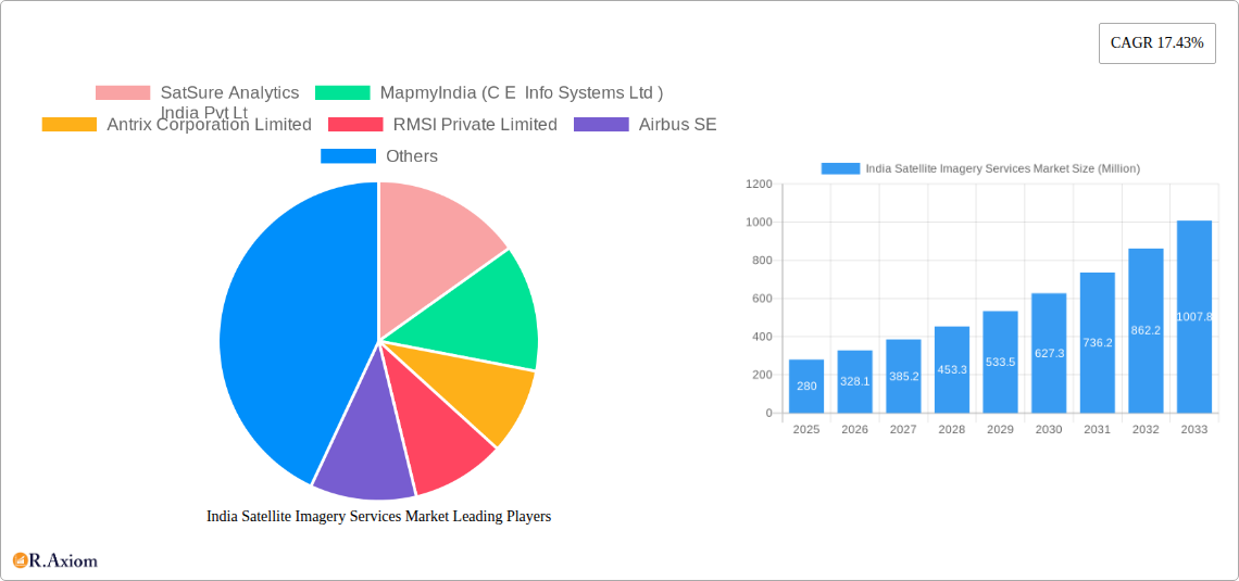
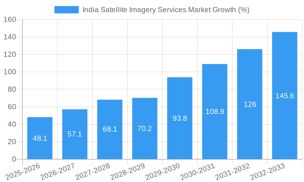
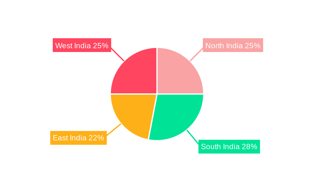
The India satellite imagery services market, valued at $0.28 billion in 2025, is poised for robust growth, exhibiting a Compound Annual Growth Rate (CAGR) of 17.43% from 2025 to 2033. This expansion is fueled by several key drivers. Firstly, increasing government initiatives focused on infrastructure development, smart city projects, and precision agriculture are driving demand for high-resolution satellite imagery. Secondly, the rising adoption of Geographic Information Systems (GIS) and advancements in data analytics are enabling more effective utilization of satellite imagery across various sectors. Thirdly, the growing need for effective disaster management and environmental monitoring further fuels market growth. The market is segmented by application (Geospatial Data Acquisition and Mapping, Natural Resource Management, Surveillance and Security, Conservation and Research, Disaster Management, Intelligence) and end-user (Government, Construction, Transportation and Logistics, Military and Defense, Forestry and Agriculture, Others). The government sector currently holds a significant market share, but growth is anticipated across all sectors, particularly in the rapidly developing construction and agriculture industries. While data privacy concerns and high initial investment costs pose some challenges, the overall market outlook remains highly positive. The regional distribution shows significant potential across all regions of India (North, South, East, and West), with the potential for faster growth in regions experiencing rapid urbanization and infrastructure development.
The competitive landscape is characterized by a mix of domestic and international players, ranging from established multinational corporations like Airbus SE and Maxar Technologies to rapidly growing Indian companies such as SatSure Analytics and MapmyIndia. This competitive dynamic fosters innovation and ensures a diverse range of service offerings to cater to the varied needs of different users. The market's future hinges on further technological advancements in satellite technology, improved data processing capabilities, and the development of innovative applications for satellite imagery data. The continued government support for digital infrastructure and the rising adoption of cloud-based solutions will further accelerate market expansion throughout the forecast period. This makes India a highly attractive market for satellite imagery providers, offering significant opportunities for growth and expansion in the coming years.
This comprehensive report provides a detailed analysis of the India Satellite Imagery Services Market, offering invaluable insights for stakeholders, investors, and industry professionals. The study period covers 2019-2033, with 2025 as the base and estimated year. The forecast period is 2025-2033, and the historical period is 2019-2024. The report segments the market by application (Geospatial Data Acquisition and Mapping, Natural Resource Management, Surveillance and Security, Conservation and Research, Disaster Management, Intelligence) and end-user (Government, Construction, Transportation and Logistics, Military and Defense, Forestry and Agriculture, Others). The market is valued at xx Million in 2025 and is projected to reach xx Million by 2033, exhibiting a CAGR of xx%.
India Satellite Imagery Services Market Concentration & Innovation
The Indian satellite imagery services market exhibits a moderately concentrated landscape, with a few dominant players and a growing number of smaller, specialized firms. Market share is largely determined by technological capabilities, data processing efficiency, and established client relationships. Major players such as Antrix Corporation Limited, MapmyIndia (CE Info Systems Ltd), and Airbus SE hold significant market share, while companies like SatSure Analytics India Pvt Ltd, RMSI Private Limited, and others are carving out niches with innovative solutions. Innovation is driven by advancements in satellite technology, improved image processing algorithms, AI-powered analytics, and the growing demand for high-resolution imagery and geospatial data.
The regulatory framework, primarily governed by the Indian Space Research Organisation (ISRO) and related agencies, plays a crucial role, influencing data access, licensing, and usage. The market also sees competition from alternative data sources such as aerial photography and LiDAR, although satellite imagery remains dominant due to its wide coverage and cost-effectiveness for large-scale projects. M&A activity has been moderate, with deal values typically ranging from xx Million to xx Million, reflecting strategic acquisitions aimed at expanding technological capabilities or market reach. Recent examples include partnerships between Indian firms and ISRO to enhance data access and develop innovative applications for geospatial services.
India Satellite Imagery Services Market Industry Trends & Insights
The Indian satellite imagery services market is experiencing robust growth, driven by several factors. Increased government spending on infrastructure projects, particularly in areas like transportation, urban development, and defense, fuels demand for high-quality geospatial data. Technological advancements, such as higher-resolution sensors and advanced analytics capabilities, are improving image quality and enhancing the value proposition of satellite imagery. Moreover, rising awareness of the potential applications of satellite imagery across various sectors, coupled with declining costs, is broadening market penetration. The government’s focus on digitalization and smart city initiatives is further stimulating demand for geospatial data and related services. Competitive dynamics are characterized by intense competition among established players and the emergence of new entrants offering innovative solutions, driving pricing pressures and technological innovation. The market has seen a significant increase in demand in recent years, leading to higher market penetration rates.
Dominant Markets & Segments in India Satellite Imagery Services Market
- Dominant Application Segment: Geospatial Data Acquisition and Mapping currently holds the largest market share, driven by the significant investment in infrastructure projects and the growing need for precise mapping solutions across various sectors.
- Dominant End-User Segment: The Government sector is the largest consumer of satellite imagery services, due to its extensive needs for national security, resource management, and infrastructure development. This segment is expected to maintain its dominance throughout the forecast period.
Key Drivers:
- Government Initiatives: Favorable government policies promoting the use of geospatial technologies and digitalization are key drivers of market growth. The "Digital India" initiative, for instance, is accelerating adoption across numerous sectors.
- Infrastructure Development: Rapid urbanization and expansion of infrastructure projects create substantial demand for high-resolution imagery for planning, monitoring, and evaluation.
- Economic Growth: India's robust economic growth is fueling investments in various sectors, thereby increasing demand for satellite imagery across various applications.
The dominance of these segments is primarily attributed to substantial government investment in infrastructure development and the growing importance of geospatial intelligence in national security and resource management.
India Satellite Imagery Services Market Product Developments
Recent product developments focus on improving image resolution, incorporating advanced analytics capabilities (e.g., AI/ML for feature extraction and classification), and developing user-friendly platforms for data access and visualization. There is a significant push towards providing value-added services that integrate satellite imagery with other data sources to offer comprehensive solutions to specific industry needs. This trend is driven by the growing demand for customized solutions and the need to extract actionable insights from geospatial data. The market is also seeing the emergence of cloud-based platforms that provide scalable and cost-effective access to satellite imagery and analytical tools.
Report Scope & Segmentation Analysis
By Application:
- Geospatial Data Acquisition and Mapping: This segment is projected to maintain its dominance, driven by the continuous need for accurate mapping and surveying. Growth is expected to be substantial, driven by increasing urbanization and infrastructure development.
- Natural Resource Management: This segment is expected to witness considerable growth, driven by the need to monitor deforestation, manage water resources, and optimize agricultural practices.
- Surveillance and Security: Growing concerns over national security and border protection are driving growth in this segment. The market is expected to expand significantly during the forecast period.
- Conservation and Research: This segment is gaining traction due to increased environmental awareness and the need for effective conservation efforts.
- Disaster Management: This segment is witnessing significant growth due to the increased frequency of natural disasters and the need for effective disaster response mechanisms.
- Intelligence: The demand for high-resolution imagery for intelligence gathering and analysis is increasing substantially.
By End-User:
- Each end-user segment shows substantial growth potential, with government and defense sectors dominating, followed by construction, transportation, and agriculture. The market is witnessing growth across all end-user sectors, with significant potential in sectors like private enterprises and utilities.
Key Drivers of India Satellite Imagery Services Market Growth
Several factors drive the growth of the Indian satellite imagery services market. These include the increasing demand for high-resolution imagery for diverse applications, government initiatives promoting geospatial technology adoption, improvements in satellite technology, the falling cost of data acquisition and processing, and the growing awareness of the economic benefits of utilizing this data. Furthermore, advancements in data analytics and the integration of AI and machine learning are expanding the applications and value proposition of satellite imagery services.
Challenges in the India Satellite Imagery Services Market Sector
Challenges include the high initial investment required for satellite technology and infrastructure, the need for skilled professionals to interpret and analyze the data, and regulatory complexities surrounding data acquisition and usage. Competition from both established players and new entrants, along with concerns regarding data privacy and security, also pose challenges. The availability of reliable internet connectivity in remote areas can also impact the market growth. These challenges, if not addressed properly, could hinder the growth of the market.
Emerging Opportunities in India Satellite Imagery Services Market
Emerging opportunities lie in the expansion of applications to new sectors such as precision agriculture, smart city development, and environmental monitoring. The integration of satellite imagery with other data sources (IoT, big data) presents considerable potential for generating valuable insights. The increasing demand for cloud-based solutions and customized services also offers significant opportunities for market expansion. Focus on developing cost-effective and user-friendly solutions can accelerate the market's growth.
Leading Players in the India Satellite Imagery Services Market Market
- SatSure Analytics India Pvt Ltd
- MapmyIndia (C E Info Systems Ltd)
- Antrix Corporation Limited
- RMSI Private Limited
- Airbus SE
- Maxar Technologies Holdings Inc
- Hexagon AB
- GIS Consortium India Private Limited
- Rolta Incorporated
- Quantduo Technologies Private Limited
- Genesys International Corporation Ltd
Key Developments in India Satellite Imagery Services Market Industry
- January 2023: ISRO's National Remote Sensing Center released satellite images of Joshimath, highlighting the utility of satellite imagery in disaster monitoring and response. This event significantly increased awareness of the practical applications of the technology and boosted demand.
- June 2022: The MoU between Pataa Navigations and IN-SPACe demonstrates the increasing collaboration between private entities and ISRO, driving innovation and expanding market access. This partnership signals a significant push toward creating innovative solutions for addressing challenges related to geolocation and digitalization.
Strategic Outlook for India Satellite Imagery Services Market Market
The Indian satellite imagery services market presents significant growth potential driven by technological advancements, government support, and increasing demand across various sectors. Further innovation in data analytics, cloud-based platforms, and the integration of satellite data with other sources will unlock further opportunities. The market is poised for considerable expansion, and companies that successfully address technological challenges and regulatory complexities are well-positioned to capitalize on this growth.
India Satellite Imagery Services Market Segmentation
-
1. Application
- 1.1. Geospatial Data Acquisition and Mapping
- 1.2. Natural Resource Management
- 1.3. Surveillance and Security
- 1.4. Conservation and Research
- 1.5. Disaster Management
- 1.6. Intelligence
-
2. End-User
- 2.1. Government
- 2.2. Construction
- 2.3. Transportation and Logistics
- 2.4. Military and Defense
- 2.5. Forestry and Agriculture
- 2.6. Others
India Satellite Imagery Services Market Segmentation By Geography
- 1. India
India Satellite Imagery Services Market REPORT HIGHLIGHTS
| Aspects | Details |
|---|---|
| Study Period | 2019-2033 |
| Base Year | 2024 |
| Estimated Year | 2025 |
| Forecast Period | 2025-2033 |
| Historical Period | 2019-2024 |
| Growth Rate | CAGR of 17.43% from 2019-2033 |
| Segmentation |
|
Table of Contents
- 1. Introduction
- 1.1. Research Scope
- 1.2. Market Segmentation
- 1.3. Research Methodology
- 1.4. Definitions and Assumptions
- 2. Executive Summary
- 2.1. Introduction
- 3. Market Dynamics
- 3.1. Introduction
- 3.2. Market Drivers
- 3.2.1. Government Initiatives to Foster the Growth of Satellite Imagery Services in India; Increasing Importance on Disaster Management and Mitigation Efforts
- 3.3. Market Restrains
- 3.3.1. Affordability and Accessibility might restrain the Market Growth; Limited Standardization and Interoperability
- 3.4. Market Trends
- 3.4.1. Government Initiatives to Foster the Growth of Satellite Imagery Services in India
- 4. Market Factor Analysis
- 4.1. Porters Five Forces
- 4.2. Supply/Value Chain
- 4.3. PESTEL analysis
- 4.4. Market Entropy
- 4.5. Patent/Trademark Analysis
- 5. India Satellite Imagery Services Market Analysis, Insights and Forecast, 2019-2031
- 5.1. Market Analysis, Insights and Forecast - by Application
- 5.1.1. Geospatial Data Acquisition and Mapping
- 5.1.2. Natural Resource Management
- 5.1.3. Surveillance and Security
- 5.1.4. Conservation and Research
- 5.1.5. Disaster Management
- 5.1.6. Intelligence
- 5.2. Market Analysis, Insights and Forecast - by End-User
- 5.2.1. Government
- 5.2.2. Construction
- 5.2.3. Transportation and Logistics
- 5.2.4. Military and Defense
- 5.2.5. Forestry and Agriculture
- 5.2.6. Others
- 5.3. Market Analysis, Insights and Forecast - by Region
- 5.3.1. India
- 5.1. Market Analysis, Insights and Forecast - by Application
- 6. North India India Satellite Imagery Services Market Analysis, Insights and Forecast, 2019-2031
- 7. South India India Satellite Imagery Services Market Analysis, Insights and Forecast, 2019-2031
- 8. East India India Satellite Imagery Services Market Analysis, Insights and Forecast, 2019-2031
- 9. West India India Satellite Imagery Services Market Analysis, Insights and Forecast, 2019-2031
- 10. Competitive Analysis
- 10.1. Market Share Analysis 2024
- 10.2. Company Profiles
- 10.2.1 SatSure Analytics
India Pvt Lt
- 10.2.1.1. Overview
- 10.2.1.2. Products
- 10.2.1.3. SWOT Analysis
- 10.2.1.4. Recent Developments
- 10.2.1.5. Financials (Based on Availability)
- 10.2.2 MapmyIndia (C E Info Systems Ltd )
- 10.2.2.1. Overview
- 10.2.2.2. Products
- 10.2.2.3. SWOT Analysis
- 10.2.2.4. Recent Developments
- 10.2.2.5. Financials (Based on Availability)
- 10.2.3 Antrix Corporation Limited
- 10.2.3.1. Overview
- 10.2.3.2. Products
- 10.2.3.3. SWOT Analysis
- 10.2.3.4. Recent Developments
- 10.2.3.5. Financials (Based on Availability)
- 10.2.4 RMSI Private Limited
- 10.2.4.1. Overview
- 10.2.4.2. Products
- 10.2.4.3. SWOT Analysis
- 10.2.4.4. Recent Developments
- 10.2.4.5. Financials (Based on Availability)
- 10.2.5 Airbus SE
- 10.2.5.1. Overview
- 10.2.5.2. Products
- 10.2.5.3. SWOT Analysis
- 10.2.5.4. Recent Developments
- 10.2.5.5. Financials (Based on Availability)
- 10.2.6 Maxar Technologies Holdings Inc
- 10.2.6.1. Overview
- 10.2.6.2. Products
- 10.2.6.3. SWOT Analysis
- 10.2.6.4. Recent Developments
- 10.2.6.5. Financials (Based on Availability)
- 10.2.7 Hexagon AB
- 10.2.7.1. Overview
- 10.2.7.2. Products
- 10.2.7.3. SWOT Analysis
- 10.2.7.4. Recent Developments
- 10.2.7.5. Financials (Based on Availability)
- 10.2.8 GIS Consortium India Private Limited
- 10.2.8.1. Overview
- 10.2.8.2. Products
- 10.2.8.3. SWOT Analysis
- 10.2.8.4. Recent Developments
- 10.2.8.5. Financials (Based on Availability)
- 10.2.9 Rolta Incorporated
- 10.2.9.1. Overview
- 10.2.9.2. Products
- 10.2.9.3. SWOT Analysis
- 10.2.9.4. Recent Developments
- 10.2.9.5. Financials (Based on Availability)
- 10.2.10 Quantduo Technologies Private Limited
- 10.2.10.1. Overview
- 10.2.10.2. Products
- 10.2.10.3. SWOT Analysis
- 10.2.10.4. Recent Developments
- 10.2.10.5. Financials (Based on Availability)
- 10.2.11 Genesys International Corporation Ltd
- 10.2.11.1. Overview
- 10.2.11.2. Products
- 10.2.11.3. SWOT Analysis
- 10.2.11.4. Recent Developments
- 10.2.11.5. Financials (Based on Availability)
- 10.2.1 SatSure Analytics
India Pvt Lt
List of Figures
- Figure 1: India Satellite Imagery Services Market Revenue Breakdown (Million, %) by Product 2024 & 2032
- Figure 2: India Satellite Imagery Services Market Share (%) by Company 2024
List of Tables
- Table 1: India Satellite Imagery Services Market Revenue Million Forecast, by Region 2019 & 2032
- Table 2: India Satellite Imagery Services Market Volume K Unit Forecast, by Region 2019 & 2032
- Table 3: India Satellite Imagery Services Market Revenue Million Forecast, by Application 2019 & 2032
- Table 4: India Satellite Imagery Services Market Volume K Unit Forecast, by Application 2019 & 2032
- Table 5: India Satellite Imagery Services Market Revenue Million Forecast, by End-User 2019 & 2032
- Table 6: India Satellite Imagery Services Market Volume K Unit Forecast, by End-User 2019 & 2032
- Table 7: India Satellite Imagery Services Market Revenue Million Forecast, by Region 2019 & 2032
- Table 8: India Satellite Imagery Services Market Volume K Unit Forecast, by Region 2019 & 2032
- Table 9: India Satellite Imagery Services Market Revenue Million Forecast, by Country 2019 & 2032
- Table 10: India Satellite Imagery Services Market Volume K Unit Forecast, by Country 2019 & 2032
- Table 11: North India India Satellite Imagery Services Market Revenue (Million) Forecast, by Application 2019 & 2032
- Table 12: North India India Satellite Imagery Services Market Volume (K Unit) Forecast, by Application 2019 & 2032
- Table 13: South India India Satellite Imagery Services Market Revenue (Million) Forecast, by Application 2019 & 2032
- Table 14: South India India Satellite Imagery Services Market Volume (K Unit) Forecast, by Application 2019 & 2032
- Table 15: East India India Satellite Imagery Services Market Revenue (Million) Forecast, by Application 2019 & 2032
- Table 16: East India India Satellite Imagery Services Market Volume (K Unit) Forecast, by Application 2019 & 2032
- Table 17: West India India Satellite Imagery Services Market Revenue (Million) Forecast, by Application 2019 & 2032
- Table 18: West India India Satellite Imagery Services Market Volume (K Unit) Forecast, by Application 2019 & 2032
- Table 19: India Satellite Imagery Services Market Revenue Million Forecast, by Application 2019 & 2032
- Table 20: India Satellite Imagery Services Market Volume K Unit Forecast, by Application 2019 & 2032
- Table 21: India Satellite Imagery Services Market Revenue Million Forecast, by End-User 2019 & 2032
- Table 22: India Satellite Imagery Services Market Volume K Unit Forecast, by End-User 2019 & 2032
- Table 23: India Satellite Imagery Services Market Revenue Million Forecast, by Country 2019 & 2032
- Table 24: India Satellite Imagery Services Market Volume K Unit Forecast, by Country 2019 & 2032
Frequently Asked Questions
1. What is the projected Compound Annual Growth Rate (CAGR) of the India Satellite Imagery Services Market?
The projected CAGR is approximately 17.43%.
2. Which companies are prominent players in the India Satellite Imagery Services Market?
Key companies in the market include SatSure Analytics India Pvt Lt, MapmyIndia (C E Info Systems Ltd ), Antrix Corporation Limited, RMSI Private Limited, Airbus SE, Maxar Technologies Holdings Inc, Hexagon AB, GIS Consortium India Private Limited, Rolta Incorporated, Quantduo Technologies Private Limited, Genesys International Corporation Ltd.
3. What are the main segments of the India Satellite Imagery Services Market?
The market segments include Application, End-User.
4. Can you provide details about the market size?
The market size is estimated to be USD 0.28 Million as of 2022.
5. What are some drivers contributing to market growth?
Government Initiatives to Foster the Growth of Satellite Imagery Services in India; Increasing Importance on Disaster Management and Mitigation Efforts.
6. What are the notable trends driving market growth?
Government Initiatives to Foster the Growth of Satellite Imagery Services in India.
7. Are there any restraints impacting market growth?
Affordability and Accessibility might restrain the Market Growth; Limited Standardization and Interoperability.
8. Can you provide examples of recent developments in the market?
January 2023: The Indian Space Research Organization's National Remote Sensing Center released satellite images of Joshimath, a town in Uttarakhand that is slowly sinking due to land subsidence, and the images show that a rapid subsidence of 5.4 cm was observed in a span of twelve days between December last week and January first week.
9. What pricing options are available for accessing the report?
Pricing options include single-user, multi-user, and enterprise licenses priced at USD 3800, USD 4500, and USD 5800 respectively.
10. Is the market size provided in terms of value or volume?
The market size is provided in terms of value, measured in Million and volume, measured in K Unit.
11. Are there any specific market keywords associated with the report?
Yes, the market keyword associated with the report is "India Satellite Imagery Services Market," which aids in identifying and referencing the specific market segment covered.
12. How do I determine which pricing option suits my needs best?
The pricing options vary based on user requirements and access needs. Individual users may opt for single-user licenses, while businesses requiring broader access may choose multi-user or enterprise licenses for cost-effective access to the report.
13. Are there any additional resources or data provided in the India Satellite Imagery Services Market report?
While the report offers comprehensive insights, it's advisable to review the specific contents or supplementary materials provided to ascertain if additional resources or data are available.
14. How can I stay updated on further developments or reports in the India Satellite Imagery Services Market?
To stay informed about further developments, trends, and reports in the India Satellite Imagery Services Market, consider subscribing to industry newsletters, following relevant companies and organizations, or regularly checking reputable industry news sources and publications.
Methodology
Step 1 - Identification of Relevant Samples Size from Population Database


Step 2 - Approaches for Defining Global Market Size (Value, Volume* & Price*)

Note*: In applicable scenarios
Step 3 - Data Sources
Primary Research
- Web Analytics
- Survey Reports
- Research Institute
- Latest Research Reports
- Opinion Leaders
Secondary Research
- Annual Reports
- White Paper
- Latest Press Release
- Industry Association
- Paid Database
- Investor Presentations

Step 4 - Data Triangulation
Involves using different sources of information in order to increase the validity of a study
These sources are likely to be stakeholders in a program - participants, other researchers, program staff, other community members, and so on.
Then we put all data in single framework & apply various statistical tools to find out the dynamic on the market.
During the analysis stage, feedback from the stakeholder groups would be compared to determine areas of agreement as well as areas of divergence


