
Key Insights
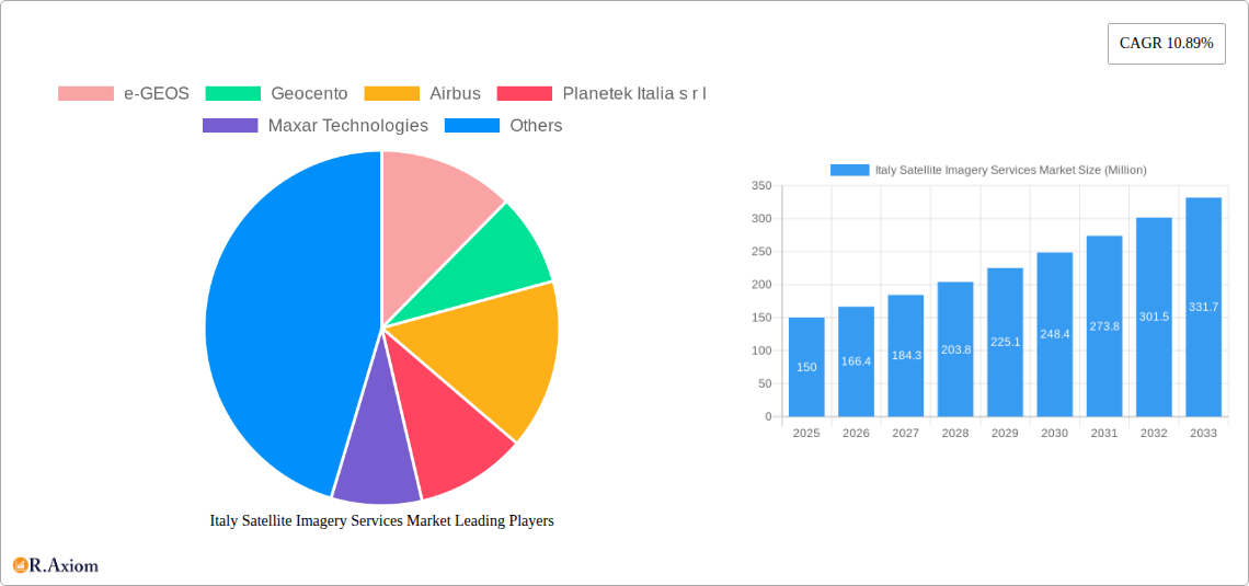
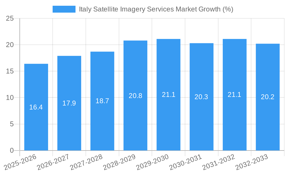
The Italian satellite imagery services market is experiencing robust growth, fueled by increasing government investments in infrastructure development, rising demand for precise geospatial data across various sectors, and advancements in satellite technology. The market, valued at approximately €150 million in 2025, is projected to exhibit a Compound Annual Growth Rate (CAGR) of 10.89% from 2025 to 2033. This expansion is driven primarily by the burgeoning geospatial data acquisition and mapping needs within the construction, transportation, and agriculture sectors. The Italian government’s emphasis on efficient resource management and national security further contributes to this market's dynamism. Key applications include precision agriculture, infrastructure monitoring, urban planning, and disaster response, all leveraging the high-resolution imagery and analytical capabilities of satellite technology. The competitive landscape is characterized by a mix of international players like Airbus and Maxar Technologies, alongside domestic firms like Planetek Italia and OHB-Italia. These companies are actively investing in research and development to enhance the accuracy, resolution, and analytical capabilities of their offerings, fostering innovation within the market.
The market segmentation reveals a strong demand from government agencies across various domains, including defense, intelligence, and environmental monitoring. The private sector, particularly the construction and transportation sectors, are also significantly contributing to the market’s growth, adopting satellite imagery for project planning, asset management, and route optimization. However, factors such as high initial investment costs for satellite technology and the potential regulatory hurdles related to data privacy and security could pose challenges to market expansion. Despite these restraints, the overall outlook for the Italian satellite imagery services market remains positive, with considerable growth opportunities anticipated in the coming years. The market is poised to benefit from emerging trends such as the increasing adoption of cloud-based platforms for data processing and analytics, as well as the growing integration of Artificial Intelligence (AI) and Machine Learning (ML) techniques to improve data interpretation and decision-making.
This in-depth report provides a comprehensive analysis of the Italy Satellite Imagery Services Market, offering invaluable insights for industry stakeholders, investors, and strategic decision-makers. The report covers the period 2019-2033, with a focus on the forecast period 2025-2033 and a base year of 2025. The market is segmented by application and end-user, revealing key trends and growth opportunities within each sector.
Italy Satellite Imagery Services Market Market Concentration & Innovation
The Italy Satellite Imagery Services Market exhibits a moderately concentrated landscape, with key players like e-GEOS, Geocento, Airbus, Planetek Italia s r l, Maxar Technologies, L3Harris Technologies, Viasat Group S p A, EUSI, Thales Alenia Space, and OHB-Italia S p A holding significant market share. Precise market share figures for each company are unavailable and require further investigation, however, industry estimates suggest a combined share exceeding xx%. Innovation is driven by advancements in sensor technology (e.g., higher resolution, multispectral imaging), data analytics (AI-powered image processing), and satellite constellation development. The regulatory framework, primarily influenced by the European Union and Italian government policies, encourages the use of satellite imagery for various applications, while also emphasizing data privacy and security. The market experiences limited substitution from alternative geospatial data acquisition methods, however, drone technology presents a growing albeit niche competition. Mergers and acquisitions (M&A) activity in the sector remains relatively low, with deal values totaling approximately xx Million in the historical period (2019-2024). Further research into recently concluded M&A deals is required to determine a more precise estimation for this value. End-user trends reflect a growing demand for high-resolution imagery across government, defense, and commercial sectors.
- Key Players: e-GEOS, Geocento, Airbus, Planetek Italia s r l, Maxar Technologies, L3Harris Technologies, Viasat Group S p A, EUSI, Thales Alenia Space, OHB-Italia S p A (List Not Exhaustive)
- Market Concentration: Moderately Concentrated (xx% combined market share of leading players)
- Innovation Drivers: Advanced sensor technology, AI-powered data analytics, satellite constellation development
- M&A Activity (2019-2024): Approximately xx Million
Italy Satellite Imagery Services Market Industry Trends & Insights
The Italy Satellite Imagery Services Market is projected to experience substantial growth during the forecast period (2025-2033), with a Compound Annual Growth Rate (CAGR) estimated at xx%. This growth is primarily driven by increasing government investment in space technology, rising demand for high-resolution imagery in various sectors (e.g., agriculture, urban planning, disaster management), and advancements in satellite technology enabling improved image quality and data processing. Technological disruptions, such as the emergence of miniaturized satellites and improved cloud-based data storage and processing platforms, further fuel market expansion. Consumer preferences are shifting towards readily accessible, high-quality satellite imagery for a wide range of purposes. Competitive dynamics are characterized by ongoing efforts to enhance data processing capabilities, provide value-added services, and expand market reach. Market penetration remains relatively high in government and defense sectors, while opportunities exist to further tap into the commercial market, specifically within agriculture, construction, and transportation & logistics.
Dominant Markets & Segments in Italy Satellite Imagery Services Market
The Government sector is the dominant end-user segment in the Italy Satellite Imagery Services Market, followed closely by the Military and Defense sector, driven by the ongoing need for geospatial intelligence and national security applications. The Geospatial Data Acquisition and Mapping application segment maintains a significant market share due to the widespread use of satellite imagery in creating detailed maps and spatial databases.
Dominant End-User Segment: Government
- Key Drivers: National security requirements, land management initiatives, urban planning needs.
Dominant Application Segment: Geospatial Data Acquisition and Mapping
- Key Drivers: Precise mapping needs for infrastructure development, environmental monitoring, and urban planning.
Other key segments demonstrating notable growth include:
- Natural Resource Management: Driven by increasing awareness of environmental sustainability and efficient resource allocation.
- Surveillance and Security: Supported by government investments in security infrastructure and advanced surveillance technologies.
- Disaster Management: Enhanced by the need for quick and precise assessments of disaster-affected areas.
- Construction: Increasingly adopting satellite imagery for project planning, site monitoring, and progress tracking.
- Transportation and Logistics: Utilizing satellite imagery to optimize route planning and supply chain management.
Italy Satellite Imagery Services Market Product Developments
Recent product innovations focus on high-resolution imagery, advanced analytics capabilities, and cloud-based platforms for easy data access and processing. These developments provide competitive advantages by offering improved image quality, enhanced data analysis, and streamlined workflows. The market trend indicates a strong emphasis on cost-effective, user-friendly solutions tailored to specific end-user needs. The fit of these products to specific sectors is largely determined by resolution, specific spectral bands, and the sophistication of included analytics.
Report Scope & Segmentation Analysis
This report comprehensively analyzes the Italy Satellite Imagery Services Market across various segments:
By Application:
- Geospatial Data Acquisition and Mapping: This segment exhibits strong growth, driven by the rising demand for detailed maps and spatial data across various sectors. Market size is estimated at xx Million in 2025, projected to reach xx Million by 2033. Competitive dynamics are intense, with numerous companies vying for market share.
- Natural Resource Management: This segment is experiencing steady growth, fueled by government initiatives and environmental concerns. Market size estimates and growth projections require further research.
- Surveillance and Security: Driven by increasing security concerns, this segment displays robust growth, with market size and growth projections requiring further research.
- Conservation and Research: This niche segment displays consistent growth due to increasing focus on environmental protection and scientific research. Market size and growth projections require further research.
- Disaster Management: This segment demonstrates rapid growth driven by the increasing frequency and severity of natural disasters. Market size and growth projections require further research.
- Intelligence: This segment shows consistent demand, however the market size and growth projections require further research due to the inherent confidentiality.
By End-User:
- Government: The largest segment, showing sustained growth due to its critical need for geospatial data. Market size is estimated at xx Million in 2025, projected to reach xx Million by 2033.
- Construction: This segment is witnessing increasing adoption of satellite imagery, driving moderate growth. Market size and growth projections require further research.
- Transportation and Logistics: This segment shows steady growth, driven by efficiency improvements in supply chains. Market size and growth projections require further research.
- Military and Defense: A significant segment, this area exhibits robust growth due to national security priorities. Market size and growth projections require further research.
- Forestry and Agriculture: This segment is seeing increasing adoption for precision agriculture and forest management. Market size and growth projections require further research.
- Others: This segment comprises various other sectors using satellite imagery, exhibiting steady but less significant growth. Market size and growth projections require further research.
Key Drivers of Italy Satellite Imagery Services Market Growth
The Italy Satellite Imagery Services Market's growth is driven by several factors:
- Technological Advancements: Improved sensor technology, enhanced data processing capabilities, and the rise of cloud-based platforms are making satellite imagery more accessible and affordable.
- Government Initiatives: Government investments in space technology and initiatives promoting the use of geospatial data for various applications are significantly boosting market growth. The IRIDE constellation launch is a prime example.
- Economic Development: Growing urbanization and industrialization create greater demand for geospatial data in urban planning, infrastructure development, and resource management.
Challenges in the Italy Satellite Imagery Services Market Sector
Despite the promising growth outlook, several challenges hinder market expansion:
- Data Privacy and Security Concerns: Strict regulations surrounding data privacy and security can pose challenges for data collection, storage, and sharing.
- High Initial Investment Costs: The high cost of acquiring and maintaining satellite imagery infrastructure can deter smaller companies from entering the market.
- Competition from Alternative Technologies: The rise of drone technology and other geospatial data acquisition methods poses some competition.
Emerging Opportunities in Italy Satellite Imagery Services Market
Emerging opportunities include:
- Expansion into New Markets: Untapped potential exists within the commercial sector, particularly in agriculture, construction, and transportation & logistics.
- Value-Added Services: Focus on providing data analytics, customized solutions, and improved data visualization enhances market value.
- Integration with IoT: Combining satellite imagery with IoT data opens up opportunities for innovative applications in smart cities and environmental monitoring.
Leading Players in the Italy Satellite Imagery Services Market Market
- e-GEOS
- Geocento
- Airbus
- Planetek Italia s r l
- Maxar Technologies
- L3Harris Technologies
- Viasat Group S p A
- EUSI
- Thales Alenia Space
- OHB-Italia S p A
Key Developments in Italy Satellite Imagery Services Market Industry
- March 2023: Arianespace signed a contract with ESA, on behalf of the Italian government, to launch the IRIDE constellation of 36 imaging satellites, starting in late 2025. This significantly boosts the Italian space industry and increases the availability of high-quality imagery.
- October 2022: Sentinel-2 satellite captured imagery of the Stromboli volcano eruption, demonstrating the real-time monitoring capabilities of satellite imagery for disaster management.
Strategic Outlook for Italy Satellite Imagery Services Market Market
The Italy Satellite Imagery Services Market exhibits strong growth potential, driven by technological advancements, increasing government investment, and growing demand across various sectors. Opportunities exist to leverage AI and machine learning to improve data analysis, enhance the integration of satellite data with IoT technologies, and expand into niche commercial markets. The market's future hinges on maintaining a balance between innovation, affordability, and regulatory compliance.
Italy Satellite Imagery Services Market Segmentation
-
1. Application
- 1.1. Geospatial Data Acquisition and Mapping
- 1.2. Natural Resource Management
- 1.3. Surveillance and Security
- 1.4. Conservation and Research
- 1.5. Disaster Management
- 1.6. Intelligence
-
2. End-User
- 2.1. Government
- 2.2. Construction
- 2.3. Transportation and Logistics
- 2.4. Military and Defense
- 2.5. Forestry and Agriculture
- 2.6. Others
Italy Satellite Imagery Services Market Segmentation By Geography
- 1. Italy
Italy Satellite Imagery Services Market REPORT HIGHLIGHTS
| Aspects | Details |
|---|---|
| Study Period | 2019-2033 |
| Base Year | 2024 |
| Estimated Year | 2025 |
| Forecast Period | 2025-2033 |
| Historical Period | 2019-2024 |
| Growth Rate | CAGR of 10.89% from 2019-2033 |
| Segmentation |
|
Table of Contents
- 1. Introduction
- 1.1. Research Scope
- 1.2. Market Segmentation
- 1.3. Research Methodology
- 1.4. Definitions and Assumptions
- 2. Executive Summary
- 2.1. Introduction
- 3. Market Dynamics
- 3.1. Introduction
- 3.2. Market Drivers
- 3.2.1. Increasing Investments to Strengthen Country's Space Economy; Adoption of Big Data and Imagery Analytics
- 3.3. Market Restrains
- 3.3.1. High Cost of Satellite Imaging Data Acquisition and Processing
- 3.4. Market Trends
- 3.4.1. Disaster Management Segment is Expected to Hold Significant Market Share
- 4. Market Factor Analysis
- 4.1. Porters Five Forces
- 4.2. Supply/Value Chain
- 4.3. PESTEL analysis
- 4.4. Market Entropy
- 4.5. Patent/Trademark Analysis
- 5. Italy Satellite Imagery Services Market Analysis, Insights and Forecast, 2019-2031
- 5.1. Market Analysis, Insights and Forecast - by Application
- 5.1.1. Geospatial Data Acquisition and Mapping
- 5.1.2. Natural Resource Management
- 5.1.3. Surveillance and Security
- 5.1.4. Conservation and Research
- 5.1.5. Disaster Management
- 5.1.6. Intelligence
- 5.2. Market Analysis, Insights and Forecast - by End-User
- 5.2.1. Government
- 5.2.2. Construction
- 5.2.3. Transportation and Logistics
- 5.2.4. Military and Defense
- 5.2.5. Forestry and Agriculture
- 5.2.6. Others
- 5.3. Market Analysis, Insights and Forecast - by Region
- 5.3.1. Italy
- 5.1. Market Analysis, Insights and Forecast - by Application
- 6. Competitive Analysis
- 6.1. Market Share Analysis 2024
- 6.2. Company Profiles
- 6.2.1 e-GEOS
- 6.2.1.1. Overview
- 6.2.1.2. Products
- 6.2.1.3. SWOT Analysis
- 6.2.1.4. Recent Developments
- 6.2.1.5. Financials (Based on Availability)
- 6.2.2 Geocento
- 6.2.2.1. Overview
- 6.2.2.2. Products
- 6.2.2.3. SWOT Analysis
- 6.2.2.4. Recent Developments
- 6.2.2.5. Financials (Based on Availability)
- 6.2.3 Airbus
- 6.2.3.1. Overview
- 6.2.3.2. Products
- 6.2.3.3. SWOT Analysis
- 6.2.3.4. Recent Developments
- 6.2.3.5. Financials (Based on Availability)
- 6.2.4 Planetek Italia s r l
- 6.2.4.1. Overview
- 6.2.4.2. Products
- 6.2.4.3. SWOT Analysis
- 6.2.4.4. Recent Developments
- 6.2.4.5. Financials (Based on Availability)
- 6.2.5 Maxar Technologies
- 6.2.5.1. Overview
- 6.2.5.2. Products
- 6.2.5.3. SWOT Analysis
- 6.2.5.4. Recent Developments
- 6.2.5.5. Financials (Based on Availability)
- 6.2.6 L3Harris Technologies*List Not Exhaustive
- 6.2.6.1. Overview
- 6.2.6.2. Products
- 6.2.6.3. SWOT Analysis
- 6.2.6.4. Recent Developments
- 6.2.6.5. Financials (Based on Availability)
- 6.2.7 Viasat Group S p A
- 6.2.7.1. Overview
- 6.2.7.2. Products
- 6.2.7.3. SWOT Analysis
- 6.2.7.4. Recent Developments
- 6.2.7.5. Financials (Based on Availability)
- 6.2.8 EUSI
- 6.2.8.1. Overview
- 6.2.8.2. Products
- 6.2.8.3. SWOT Analysis
- 6.2.8.4. Recent Developments
- 6.2.8.5. Financials (Based on Availability)
- 6.2.9 Thales Alenia Space
- 6.2.9.1. Overview
- 6.2.9.2. Products
- 6.2.9.3. SWOT Analysis
- 6.2.9.4. Recent Developments
- 6.2.9.5. Financials (Based on Availability)
- 6.2.10 OHB-Italia S p A
- 6.2.10.1. Overview
- 6.2.10.2. Products
- 6.2.10.3. SWOT Analysis
- 6.2.10.4. Recent Developments
- 6.2.10.5. Financials (Based on Availability)
- 6.2.1 e-GEOS
List of Figures
- Figure 1: Italy Satellite Imagery Services Market Revenue Breakdown (Million, %) by Product 2024 & 2032
- Figure 2: Italy Satellite Imagery Services Market Share (%) by Company 2024
List of Tables
- Table 1: Italy Satellite Imagery Services Market Revenue Million Forecast, by Region 2019 & 2032
- Table 2: Italy Satellite Imagery Services Market Revenue Million Forecast, by Application 2019 & 2032
- Table 3: Italy Satellite Imagery Services Market Revenue Million Forecast, by End-User 2019 & 2032
- Table 4: Italy Satellite Imagery Services Market Revenue Million Forecast, by Region 2019 & 2032
- Table 5: Italy Satellite Imagery Services Market Revenue Million Forecast, by Country 2019 & 2032
- Table 6: Italy Satellite Imagery Services Market Revenue Million Forecast, by Application 2019 & 2032
- Table 7: Italy Satellite Imagery Services Market Revenue Million Forecast, by End-User 2019 & 2032
- Table 8: Italy Satellite Imagery Services Market Revenue Million Forecast, by Country 2019 & 2032
Frequently Asked Questions
1. What is the projected Compound Annual Growth Rate (CAGR) of the Italy Satellite Imagery Services Market?
The projected CAGR is approximately 10.89%.
2. Which companies are prominent players in the Italy Satellite Imagery Services Market?
Key companies in the market include e-GEOS, Geocento, Airbus, Planetek Italia s r l, Maxar Technologies, L3Harris Technologies*List Not Exhaustive, Viasat Group S p A, EUSI, Thales Alenia Space, OHB-Italia S p A.
3. What are the main segments of the Italy Satellite Imagery Services Market?
The market segments include Application, End-User.
4. Can you provide details about the market size?
The market size is estimated to be USD XX Million as of 2022.
5. What are some drivers contributing to market growth?
Increasing Investments to Strengthen Country's Space Economy; Adoption of Big Data and Imagery Analytics.
6. What are the notable trends driving market growth?
Disaster Management Segment is Expected to Hold Significant Market Share.
7. Are there any restraints impacting market growth?
High Cost of Satellite Imaging Data Acquisition and Processing.
8. Can you provide examples of recent developments in the market?
March 2023: Arianespace announced signing a contract with the European Space Agency (ESA), acting on behalf of the Italian government, for launching the IRIDE constellation of imaging satellites. The agreement includes two firm Vega C launches, starting in late 2025, with an option for a third. The Italian government funds the IRIDE constellation. It will consist of 36 satellites built by a consortium of Italian companies equipped with various imaging payloads, including optical and radar.
9. What pricing options are available for accessing the report?
Pricing options include single-user, multi-user, and enterprise licenses priced at USD 3800, USD 4500, and USD 5800 respectively.
10. Is the market size provided in terms of value or volume?
The market size is provided in terms of value, measured in Million.
11. Are there any specific market keywords associated with the report?
Yes, the market keyword associated with the report is "Italy Satellite Imagery Services Market," which aids in identifying and referencing the specific market segment covered.
12. How do I determine which pricing option suits my needs best?
The pricing options vary based on user requirements and access needs. Individual users may opt for single-user licenses, while businesses requiring broader access may choose multi-user or enterprise licenses for cost-effective access to the report.
13. Are there any additional resources or data provided in the Italy Satellite Imagery Services Market report?
While the report offers comprehensive insights, it's advisable to review the specific contents or supplementary materials provided to ascertain if additional resources or data are available.
14. How can I stay updated on further developments or reports in the Italy Satellite Imagery Services Market?
To stay informed about further developments, trends, and reports in the Italy Satellite Imagery Services Market, consider subscribing to industry newsletters, following relevant companies and organizations, or regularly checking reputable industry news sources and publications.
Methodology
Step 1 - Identification of Relevant Samples Size from Population Database


Step 2 - Approaches for Defining Global Market Size (Value, Volume* & Price*)

Note*: In applicable scenarios
Step 3 - Data Sources
Primary Research
- Web Analytics
- Survey Reports
- Research Institute
- Latest Research Reports
- Opinion Leaders
Secondary Research
- Annual Reports
- White Paper
- Latest Press Release
- Industry Association
- Paid Database
- Investor Presentations

Step 4 - Data Triangulation
Involves using different sources of information in order to increase the validity of a study
These sources are likely to be stakeholders in a program - participants, other researchers, program staff, other community members, and so on.
Then we put all data in single framework & apply various statistical tools to find out the dynamic on the market.
During the analysis stage, feedback from the stakeholder groups would be compared to determine areas of agreement as well as areas of divergence


